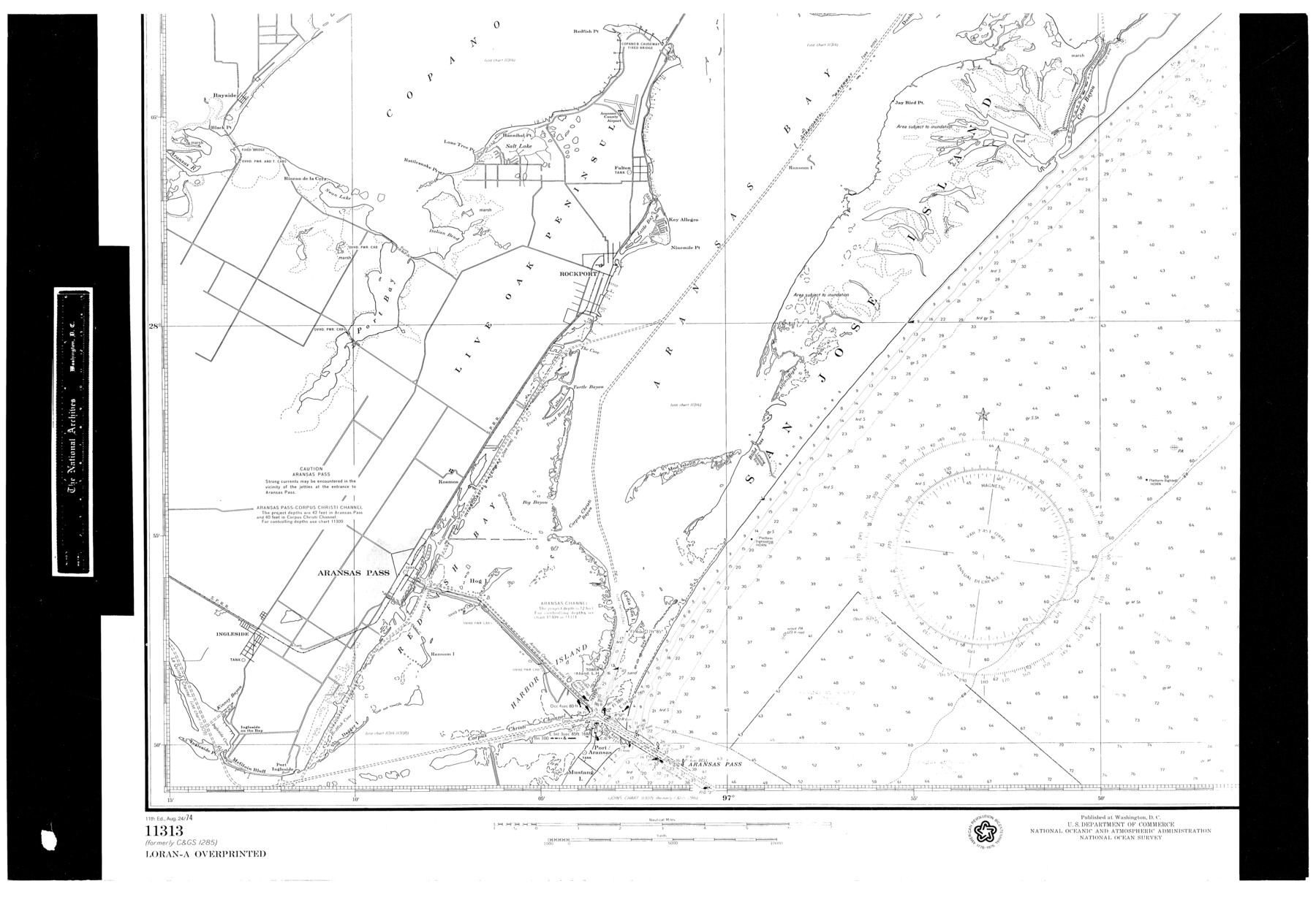
Calhoun County Rolled Sketch 30
Matagorda Light to Aransas Pass
-
Map/Doc
5487
-
Collection
General Map Collection
-
Object Dates
1974 (Creation Date)
1978/10/5 (File Date)
-
People and Organizations
U.S.C. and G.S. (Surveyor/Engineer)
-
Counties
Calhoun
-
Subjects
Surveying Rolled Sketch
-
Height x Width
18.6 x 27.3 inches
47.2 x 69.3 cm
Part of: General Map Collection
Angelina County Working Sketch 50

Print $20.00
- Digital $50.00
Angelina County Working Sketch 50
1985
Size 34.2 x 43.2 inches
Map/Doc 67133

Archer County Working Sketch 9

Print $20.00
- Digital $50.00
Archer County Working Sketch 9
1924
Size 22.2 x 29.8 inches
Map/Doc 67149
Washington County

Print $40.00
- Digital $50.00
Washington County
1920
Size 33.4 x 48.6 inches
Map/Doc 63112
University Lands Blocks 34 to 37, Terrell County

Print $20.00
- Digital $50.00
University Lands Blocks 34 to 37, Terrell County
1938
Size 32.8 x 40.0 inches
Map/Doc 2451
Map of Lipscomb County

Print $20.00
- Digital $50.00
Map of Lipscomb County
1899
Size 42.2 x 38.9 inches
Map/Doc 95572
Eastland County Working Sketch 47

Print $20.00
- Digital $50.00
Eastland County Working Sketch 47
1981
Size 30.0 x 27.1 inches
Map/Doc 68828
Gaines County Sketch File 2a

Print $16.00
- Digital $50.00
Gaines County Sketch File 2a
Size 9.0 x 8.9 inches
Map/Doc 23167
Flight Mission No. DQO-8K, Frame 56, Galveston County

Print $20.00
- Digital $50.00
Flight Mission No. DQO-8K, Frame 56, Galveston County
1952
Size 18.7 x 17.6 inches
Map/Doc 85163
Brewster County Rolled Sketch 108

Print $20.00
- Digital $50.00
Brewster County Rolled Sketch 108
1958
Size 29.8 x 17.1 inches
Map/Doc 5260
Map of Fayette County

Print $20.00
- Digital $50.00
Map of Fayette County
1843
Size 21.9 x 26.7 inches
Map/Doc 3537
Archer County Sketch File 29

Print $80.00
- Digital $50.00
Archer County Sketch File 29
1888
Size 21.8 x 16.5 inches
Map/Doc 10836
You may also like
[Pitchfork Ranch]
![4480, [Pitchfork Ranch], Maddox Collection](https://historictexasmaps.com/wmedia_w700/maps/4480.tif.jpg)
Print $20.00
- Digital $50.00
[Pitchfork Ranch]
1915
Size 20.8 x 17.2 inches
Map/Doc 4480
Culberson County Sketch File 39

Print $12.00
- Digital $50.00
Culberson County Sketch File 39
1968
Size 11.2 x 8.7 inches
Map/Doc 20306

Childress County, Texas

Print $20.00
- Digital $50.00
Childress County, Texas
1890
Size 19.9 x 16.9 inches
Map/Doc 673
Houston County Working Sketch 20

Print $20.00
- Digital $50.00
Houston County Working Sketch 20
1979
Size 26.7 x 24.0 inches
Map/Doc 66250
Flight Mission No. DAH-9M, Frame 158, Orange County

Print $20.00
- Digital $50.00
Flight Mission No. DAH-9M, Frame 158, Orange County
1953
Size 18.4 x 22.3 inches
Map/Doc 86857
Harris County Boundary File 39 (16)

Print $6.00
- Digital $50.00
Harris County Boundary File 39 (16)
Size 10.0 x 8.0 inches
Map/Doc 54354
Brewster County Sketch File N-2

Print $44.00
- Digital $50.00
Brewster County Sketch File N-2
1881
Size 8.2 x 12.8 inches
Map/Doc 15567
Harris County Sketch File 79

Print $20.00
- Digital $50.00
Harris County Sketch File 79
1972
Size 28.9 x 33.2 inches
Map/Doc 10481
Fractional Township No. 8 South Range No. 23 East of the Indian Meridian, Indian Territory

Print $20.00
- Digital $50.00
Fractional Township No. 8 South Range No. 23 East of the Indian Meridian, Indian Territory
1898
Size 19.1 x 24.3 inches
Map/Doc 75249
Aransas County NRC Article 33.136 Sketch 14

Print $36.00
- Digital $50.00
Aransas County NRC Article 33.136 Sketch 14
2016
Size 18.0 x 24.0 inches
Map/Doc 94795
Goliad County Sketch File 1

Print $24.00
- Digital $50.00
Goliad County Sketch File 1
1857
Size 12.5 x 7.5 inches
Map/Doc 24211