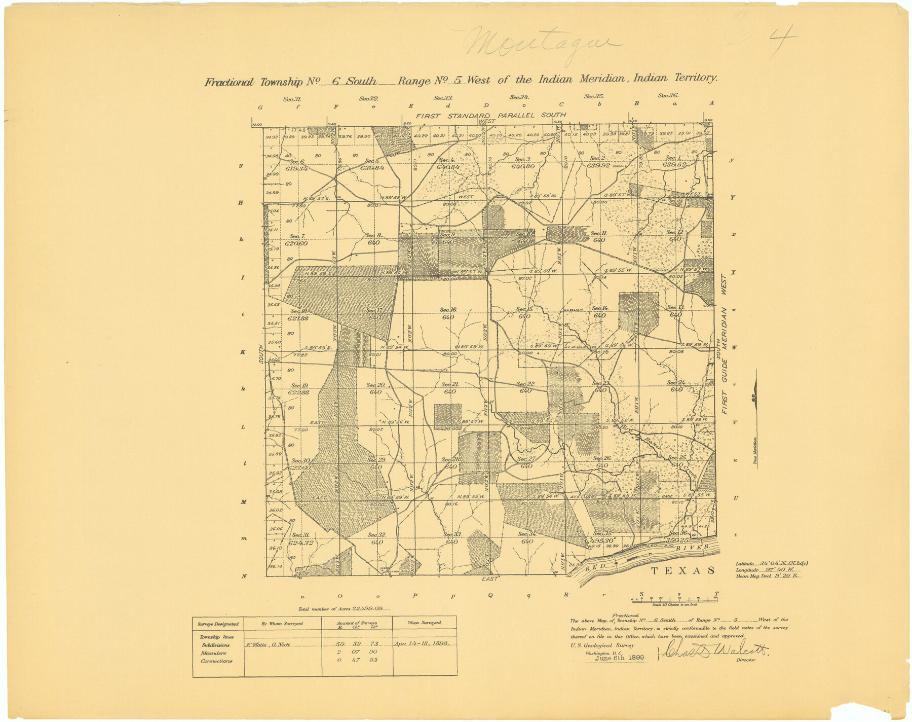
Fractional Township No. 6 South Range No. 5 West of the Indian Meridian, Indian Territory
-
Map/Doc
75190
-
Collection
General Map Collection
-
Object Dates
1898/4/18 (Creation Date)
-
Subjects
Texas Boundaries
-
Height x Width
19.3 x 24.3 inches
49.0 x 61.7 cm
Part of: General Map Collection
Map of the country in the vicinity of San Antonio de Bexar reduced in part from the county map of Bexar with additions by J. Edmd. Blake, 1st Lieut Topl. Engs.

Print $20.00
- Digital $50.00
Map of the country in the vicinity of San Antonio de Bexar reduced in part from the county map of Bexar with additions by J. Edmd. Blake, 1st Lieut Topl. Engs.
1845
Size 18.3 x 26.1 inches
Map/Doc 72720
Flight Mission No. DCL-5C, Frame 75, Kenedy County

Print $20.00
- Digital $50.00
Flight Mission No. DCL-5C, Frame 75, Kenedy County
1943
Size 18.6 x 22.2 inches
Map/Doc 85858
Baylor County Sketch File A9

Print $8.00
- Digital $50.00
Baylor County Sketch File A9
1926
Size 11.4 x 8.9 inches
Map/Doc 14096
Ward County Working Sketch 3

Print $20.00
- Digital $50.00
Ward County Working Sketch 3
1935
Size 24.1 x 27.1 inches
Map/Doc 72309
Young County Working Sketch 18

Print $20.00
- Digital $50.00
Young County Working Sketch 18
1960
Size 23.9 x 29.2 inches
Map/Doc 62041
Collingsworth County Sketch File 2

Print $20.00
- Digital $50.00
Collingsworth County Sketch File 2
1888
Size 24.3 x 31.3 inches
Map/Doc 11129
Freestone County Working Sketch 22

Print $20.00
- Digital $50.00
Freestone County Working Sketch 22
1981
Size 35.5 x 32.3 inches
Map/Doc 69264
Flight Mission No. BRE-2P, Frame 80, Nueces County

Print $20.00
- Digital $50.00
Flight Mission No. BRE-2P, Frame 80, Nueces County
1956
Size 18.4 x 22.5 inches
Map/Doc 86775
Galveston County NRC Article 33.136 Sketch 51

Print $20.00
- Digital $50.00
Galveston County NRC Article 33.136 Sketch 51
Size 24.0 x 36.0 inches
Map/Doc 93785
Flight Mission No. DQO-11K, Frame 18, Galveston County

Print $20.00
- Digital $50.00
Flight Mission No. DQO-11K, Frame 18, Galveston County
1952
Size 18.7 x 22.4 inches
Map/Doc 85211
Castro County Working Sketch 1

Print $20.00
- Digital $50.00
Castro County Working Sketch 1
Size 22.8 x 17.7 inches
Map/Doc 67896
Jasper County Sketch File 24

Print $4.00
- Digital $50.00
Jasper County Sketch File 24
1925
Size 10.9 x 8.3 inches
Map/Doc 27824
You may also like
Map of north end of Brazos Island

Print $20.00
- Digital $50.00
Map of north end of Brazos Island
Size 27.7 x 18.3 inches
Map/Doc 72907
Map of Kyle, Lockhart & Southern Ry.

Print $40.00
- Digital $50.00
Map of Kyle, Lockhart & Southern Ry.
1882
Size 14.5 x 94.9 inches
Map/Doc 64285
Cherokee County Sketch File 11

Print $4.00
- Digital $50.00
Cherokee County Sketch File 11
1852
Size 11.5 x 8.2 inches
Map/Doc 18138
Outer Continental Shelf Leasing Maps (Louisiana Offshore Operations)

Print $20.00
- Digital $50.00
Outer Continental Shelf Leasing Maps (Louisiana Offshore Operations)
1954
Size 21.2 x 16.3 inches
Map/Doc 76103
Webb County Sketch File 60

Print $8.00
- Digital $50.00
Webb County Sketch File 60
1943
Size 14.4 x 8.9 inches
Map/Doc 39855
Angelina County Sketch File 21b

Print $6.00
- Digital $50.00
Angelina County Sketch File 21b
1889
Size 13.9 x 8.5 inches
Map/Doc 13044
Flight Mission No. DCL-5C, Frame 2, Kenedy County

Print $20.00
- Digital $50.00
Flight Mission No. DCL-5C, Frame 2, Kenedy County
1943
Size 18.5 x 22.5 inches
Map/Doc 85827
Moore County Boundary File 1

Print $42.00
- Digital $50.00
Moore County Boundary File 1
Size 8.9 x 3.8 inches
Map/Doc 57452
El Paso County Boundary File 25

Print $10.00
- Digital $50.00
El Paso County Boundary File 25
Size 13.0 x 8.9 inches
Map/Doc 53226
Ochiltree County Boundary File 7

Print $20.00
- Digital $50.00
Ochiltree County Boundary File 7
Size 36.1 x 9.3 inches
Map/Doc 57715
Flight Mission No. BRA-17M, Frame 2, Jefferson County

Print $20.00
- Digital $50.00
Flight Mission No. BRA-17M, Frame 2, Jefferson County
1953
Size 18.6 x 22.3 inches
Map/Doc 85782
Freestone County Rolled Sketch 13A

Print $20.00
- Digital $50.00
Freestone County Rolled Sketch 13A
1990
Size 45.2 x 33.7 inches
Map/Doc 5914