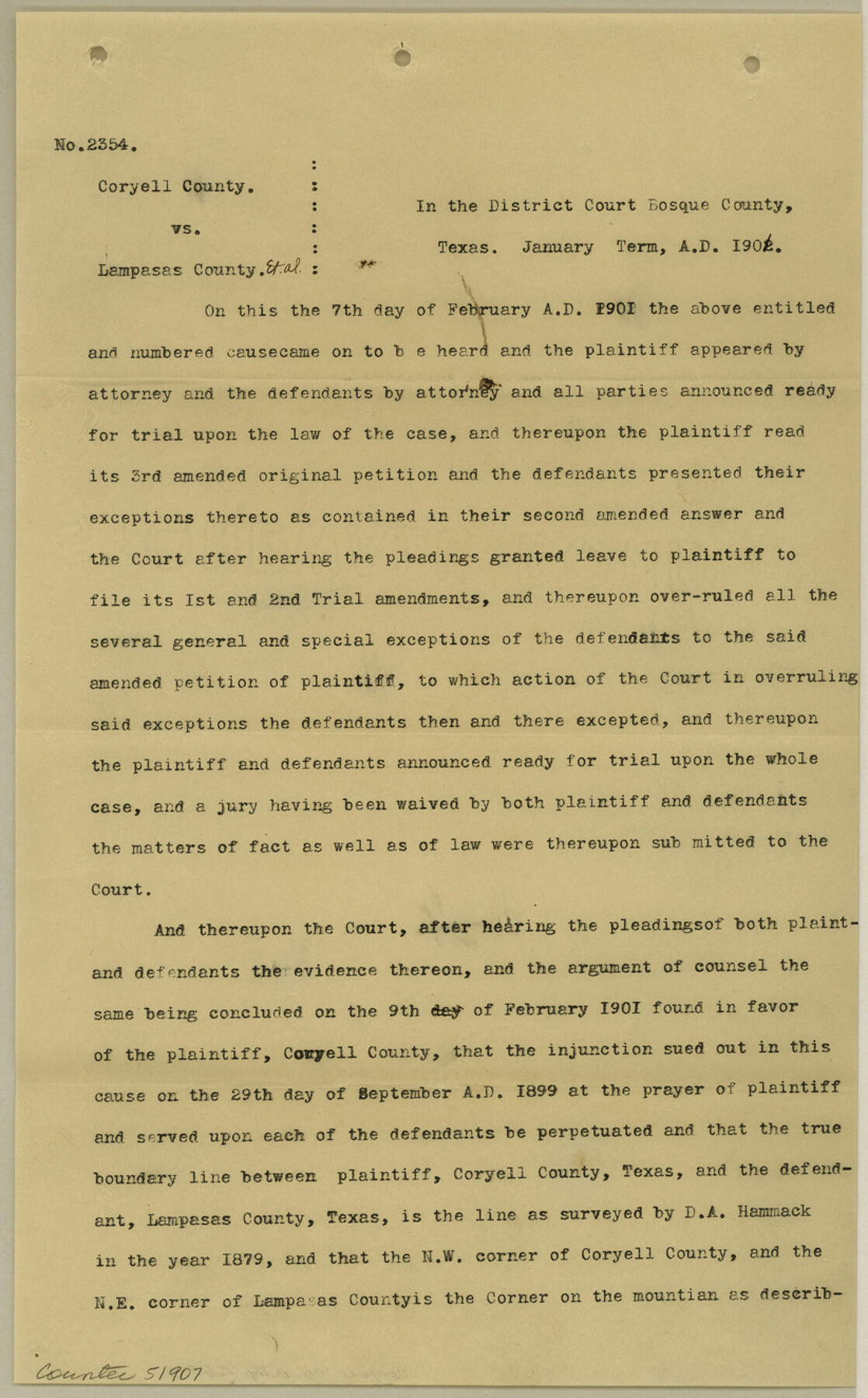
Coryell County Boundary File 3
Judgement, Cause No. 2354, Coryell County vs. Lampasas County, et al.
- 
                          Map/Doc
51907
 - 
                            Collection
General Map Collection
 - 
                            Counties
Coryell
 - 
                            Subjects
County Boundaries
 - 
                            Height x Width
13.2 x 8.2 inches
33.5 x 20.8 cm
 
Part of: General Map Collection
            Polk County Working Sketch 11


                                            Print $20.00                    
                                             -                         Digital $50.00                                    
                Polk County Working Sketch 11
1940
Size 29.3 x 28.6 inches
                                Map/Doc 71626
            
            Marion County Working Sketch 43


                                            Print $5.00                    
                                             -                         Digital $50.00                                    
                Marion County Working Sketch 43
2002
Size 28.6 x 29.0 inches
                                Map/Doc 78214
            
            Ector County Working Sketch 14


                                            Print $40.00                    
                                             -                         Digital $50.00                                    
                Ector County Working Sketch 14
1955
Size 72.7 x 43.4 inches
                                Map/Doc 68857
            
            Montgomery County Rolled Sketch 48


                                            Print $20.00                    
                                             -                         Digital $50.00                                    
                Montgomery County Rolled Sketch 48
2007
Size 11.2 x 17.2 inches
                                Map/Doc 89278
            
            Flight Mission No. CZW-3R, Frame 82


                                            Print $20.00                    
                                             -                         Digital $50.00                                    
                Flight Mission No. CZW-3R, Frame 82
1956
Size 18.6 x 22.3 inches
                                Map/Doc 85240
            
            Flight Mission No. BRA-8M, Frame 71, Jefferson County


                                            Print $20.00                    
                                             -                         Digital $50.00                                    
                Flight Mission No. BRA-8M, Frame 71, Jefferson County
1953
Size 18.7 x 22.3 inches
                                Map/Doc 85591
            
            Bell County Working Sketch 11


                                            Print $20.00                    
                                             -                         Digital $50.00                                    
                Bell County Working Sketch 11
1956
Size 31.8 x 24.4 inches
                                Map/Doc 67351
            
            Chocolate Bay, West Portion of West Bay and Vicinity, Brazoria and Galveston Counties, showing Subdivision for Mineral Development


                                            Print $40.00                    
                                             -                         Digital $50.00                                    
                Chocolate Bay, West Portion of West Bay and Vicinity, Brazoria and Galveston Counties, showing Subdivision for Mineral Development
1948
Size 40.7 x 53.9 inches
                                Map/Doc 1907
            
            Leon County Working Sketch 33


                                            Print $20.00                    
                                             -                         Digital $50.00                                    
                Leon County Working Sketch 33
1978
Size 43.4 x 41.6 inches
                                Map/Doc 70432
            
            A Map of Lewis and Clark's Track, across the Western Portion of North America from the Mississippi to the Pacific Ocean; by order of the Executive of the United States in 1804, 5 & 6


                                            Print $20.00                    
                                             -                         Digital $50.00                                    
                A Map of Lewis and Clark's Track, across the Western Portion of North America from the Mississippi to the Pacific Ocean; by order of the Executive of the United States in 1804, 5 & 6
1962
Size 11.5 x 25.1 inches
                                Map/Doc 97174
            
            Map of Concho County


                                            Print $20.00                    
                                             -                         Digital $50.00                                    
                Map of Concho County
1897
Size 46.9 x 38.4 inches
                                Map/Doc 4919
            
            Austin Old and New, a Mapguide to the Heart of the City including Capitol Complex & Government Buildings, Downtown Streets and Buildings, the University of Texas, Historical Sites, Parks & Trails, Sixth Street, Town Lake, Museums


            Austin Old and New, a Mapguide to the Heart of the City including Capitol Complex & Government Buildings, Downtown Streets and Buildings, the University of Texas, Historical Sites, Parks & Trails, Sixth Street, Town Lake, Museums
Size 25.4 x 31.2 inches
                                Map/Doc 94380
            You may also like
            Gaines County Working Sketch 5


                                            Print $20.00                    
                                             -                         Digital $50.00                                    
                Gaines County Working Sketch 5
1940
Size 24.2 x 41.4 inches
                                Map/Doc 69305
            
            Fort Bend County Working Sketch 17


                                            Print $20.00                    
                                             -                         Digital $50.00                                    
                Fort Bend County Working Sketch 17
1955
Size 25.1 x 31.1 inches
                                Map/Doc 69223
            
            Atlas Geográfico, Estadístico é Histórico de la República Mexicana


            Atlas Geográfico, Estadístico é Histórico de la República Mexicana
Map/Doc 95689
            
            Coryell County Sketch File 4


                                            Print $6.00                    
                                             -                         Digital $50.00                                    
                Coryell County Sketch File 4
1854
Size 12.8 x 8.2 inches
                                Map/Doc 19342
            
            Current Miscellaneous File 29


                                            Print $10.00                    
                                             -                         Digital $50.00                                    
                Current Miscellaneous File 29
Size 11.2 x 8.8 inches
                                Map/Doc 73920
            
            Harris County Working Sketch 98


                                            Print $20.00                    
                                             -                         Digital $50.00                                    
                Harris County Working Sketch 98
1979
Size 44.2 x 28.4 inches
                                Map/Doc 65990
            
            Kimble County Working Sketch 12


                                            Print $20.00                    
                                             -                         Digital $50.00                                    
                Kimble County Working Sketch 12
1922
Size 27.6 x 19.5 inches
                                Map/Doc 70080
            
            Flight Mission No. DAG-18K, Frame 185, Matagorda County


                                            Print $20.00                    
                                             -                         Digital $50.00                                    
                Flight Mission No. DAG-18K, Frame 185, Matagorda County
1952
Size 16.2 x 15.9 inches
                                Map/Doc 86377
            
            [Map of the River Sabine from its mouth on the Gulf of Mexico in the sea to Logan's Ferry in Latitude 31° 58' 24" North]


                                            Print $20.00                    
                                             -                         Digital $50.00                                    
                [Map of the River Sabine from its mouth on the Gulf of Mexico in the sea to Logan's Ferry in Latitude 31° 58' 24" North]
Size 37.7 x 31.6 inches
                                Map/Doc 94006
            
            Meadowbrook Villa a Subdivision in Section 77, Blk A


                                            Print $20.00                    
                                             -                         Digital $50.00                                    
                Meadowbrook Villa a Subdivision in Section 77, Blk A
Size 14.4 x 13.1 inches
                                Map/Doc 92768
            
            Lavaca County Sketch File 23


                                            Print $20.00                    
                                             -                         Digital $50.00                                    
                Lavaca County Sketch File 23
1986
Size 14.0 x 8.6 inches
                                Map/Doc 29668
            
            Bexar County Working Sketch 5


                                            Print $20.00                    
                                             -                         Digital $50.00                                    
                Bexar County Working Sketch 5
1943
Size 25.3 x 25.0 inches
                                Map/Doc 67321