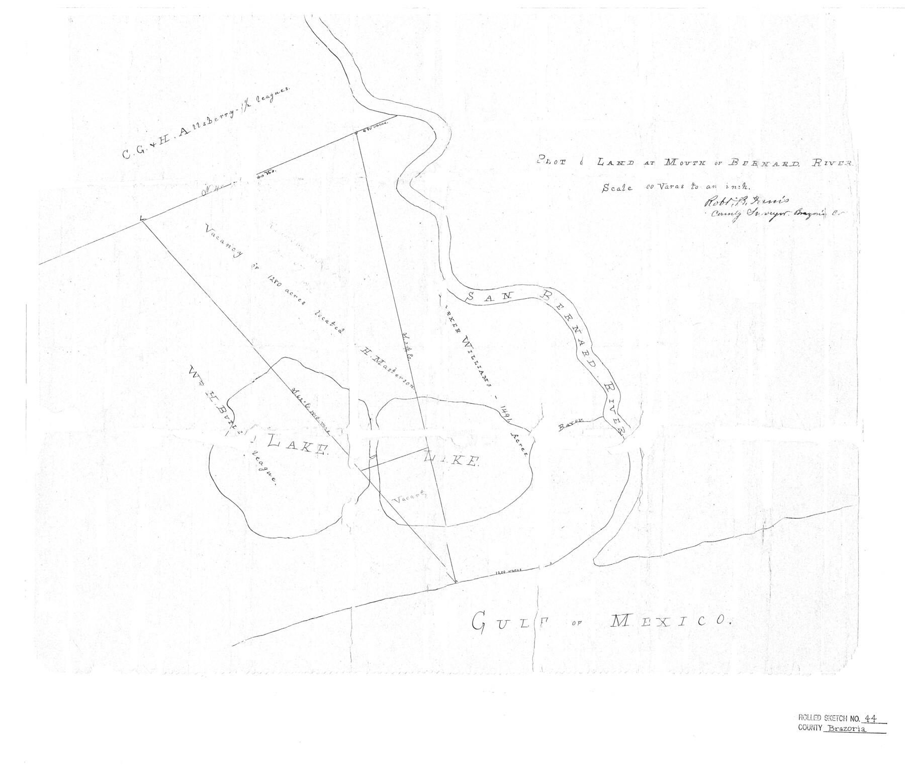
Brazoria County Rolled Sketch 44
Plot & land at mouth of Bernard River
-
Map/Doc
5178
-
Collection
General Map Collection
-
Object Dates
1885 (Creation Date)
1885/4/28 (File Date)
-
People and Organizations
Robt. B. Harris (Surveyor/Engineer)
-
Counties
Brazoria
-
Subjects
Surveying Rolled Sketch
-
Height x Width
23.0 x 27.0 inches
58.4 x 68.6 cm
-
Medium
paper, manuscript
Part of: General Map Collection
Real County Working Sketch 25

Print $4.00
- Digital $50.00
Real County Working Sketch 25
1946
Size 26.5 x 24.7 inches
Map/Doc 71917
Maverick County Rolled Sketch 19

Print $20.00
- Digital $50.00
Maverick County Rolled Sketch 19
1955
Size 33.5 x 44.1 inches
Map/Doc 9494
Texas Gulf Coast from Sabine River to the Rio Grande

Print $20.00
- Digital $50.00
Texas Gulf Coast from Sabine River to the Rio Grande
1953
Size 45.9 x 43.6 inches
Map/Doc 2945
Kaufman County Working Sketch 3

Print $2.00
- Digital $50.00
Kaufman County Working Sketch 3
1922
Size 11.9 x 8.0 inches
Map/Doc 66666
Map of Jack County

Print $20.00
- Digital $50.00
Map of Jack County
1896
Size 43.6 x 38.9 inches
Map/Doc 66877
Bailey County Sketch File 4

Print $8.00
- Digital $50.00
Bailey County Sketch File 4
1907
Size 14.2 x 8.7 inches
Map/Doc 13954
Flight Mission No. CZW-3R, Frame 82

Print $20.00
- Digital $50.00
Flight Mission No. CZW-3R, Frame 82
1956
Size 18.6 x 22.3 inches
Map/Doc 85240
Polk County Sketch File 11

Print $4.00
- Digital $50.00
Polk County Sketch File 11
Size 9.2 x 8.1 inches
Map/Doc 34142
Eastland County Sketch File 13

Print $4.00
- Digital $50.00
Eastland County Sketch File 13
1887
Size 8.3 x 13.0 inches
Map/Doc 21593
Reagan County Sketch File 7

Print $6.00
- Digital $50.00
Reagan County Sketch File 7
1928
Size 11.2 x 8.7 inches
Map/Doc 34986
Central Part of Jeff Davis Co.

Print $40.00
- Digital $50.00
Central Part of Jeff Davis Co.
1982
Size 55.4 x 43.9 inches
Map/Doc 73193
Runnels County Working Sketch 33

Print $20.00
- Digital $50.00
Runnels County Working Sketch 33
Size 26.5 x 22.6 inches
Map/Doc 63631
You may also like
[Block M-19, and G. & M. Blocks 4 and 5]
![91784, [Block M-19, and G. & M. Blocks 4 and 5], Twichell Survey Records](https://historictexasmaps.com/wmedia_w700/maps/91784-1.tif.jpg)
Print $20.00
- Digital $50.00
[Block M-19, and G. & M. Blocks 4 and 5]
Size 22.4 x 17.7 inches
Map/Doc 91784
Andrews County Sketch File 6

Print $9.00
- Digital $50.00
Andrews County Sketch File 6
1942
Size 9.6 x 10.6 inches
Map/Doc 12825
Montague County Working Sketch 43

Print $20.00
- Digital $50.00
Montague County Working Sketch 43
2010
Size 23.3 x 27.2 inches
Map/Doc 89284

Subdivision of the J. F. Carter Estate

Print $3.00
- Digital $50.00
Subdivision of the J. F. Carter Estate
Size 11.8 x 9.6 inches
Map/Doc 91273

Bailey County Sketch File 13

Print $40.00
- Digital $50.00
Bailey County Sketch File 13
1912
Size 19.2 x 20.6 inches
Map/Doc 10888
San Jacinto County Sketch File 7

Print $10.00
- Digital $50.00
San Jacinto County Sketch File 7
1848
Size 8.1 x 10.0 inches
Map/Doc 35705
Burnet County Working Sketch 20

Print $40.00
- Digital $50.00
Burnet County Working Sketch 20
1983
Size 48.1 x 41.2 inches
Map/Doc 67863
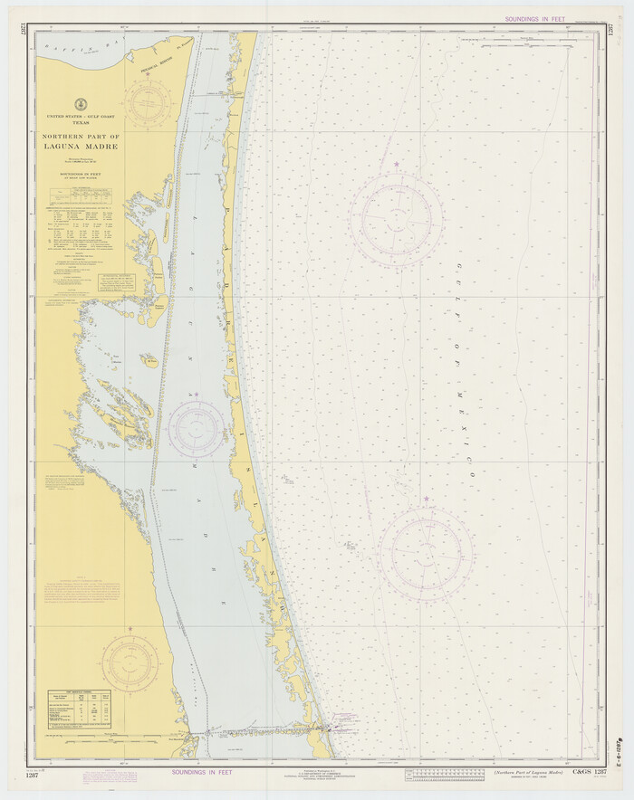
Northern Part of Laguna Madre
Print $20.00
- Digital $50.00
Northern Part of Laguna Madre
1972
Size 44.2 x 35.0 inches
Map/Doc 73529
Dallas, Ft. Worth, & Vicinity, Texas - Regional Map

Dallas, Ft. Worth, & Vicinity, Texas - Regional Map
1997
Size 25.7 x 36.7 inches
Map/Doc 97289
Angelina County Working Sketch 41

Print $20.00
- Digital $50.00
Angelina County Working Sketch 41
1960
Size 33.9 x 21.6 inches
Map/Doc 67124