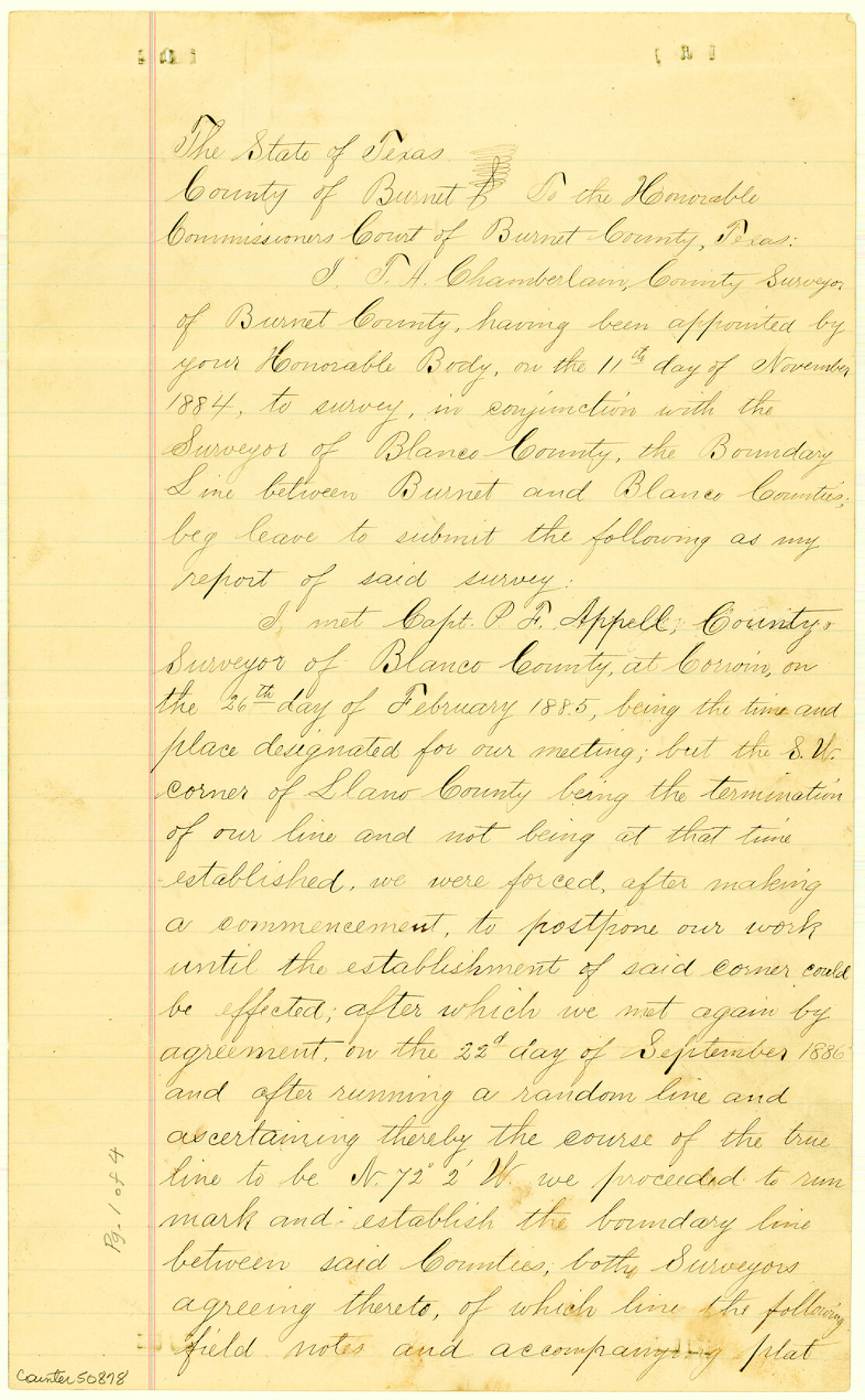
Burnet County Boundary File 5
Surveyors Report on Burnet and Blanco County Line
-
Map/Doc
50878
-
Collection
General Map Collection
-
Counties
Burnet
-
Subjects
County Boundaries
-
Height x Width
12.7 x 7.9 inches
32.3 x 20.1 cm
Part of: General Map Collection

Val Verde County Working Sketch Graphic Index, Sheet 1 (Sketches 1 to 25)

Print $20.00
- Digital $50.00
Val Verde County Working Sketch Graphic Index, Sheet 1 (Sketches 1 to 25)
1944
Size 40.4 x 36.5 inches
Map/Doc 76724
Fisher County Sketch File 19

Print $20.00
- Digital $50.00
Fisher County Sketch File 19
Size 18.8 x 15.7 inches
Map/Doc 11481
Upton County Rolled Sketch 4

Print $20.00
- Digital $50.00
Upton County Rolled Sketch 4
Size 34.4 x 42.8 inches
Map/Doc 76025
Val Verde County Sketch File 33

Print $40.00
- Digital $50.00
Val Verde County Sketch File 33
Size 17.5 x 13.9 inches
Map/Doc 39249
Hall County Sketch File 9a

Print $4.00
- Digital $50.00
Hall County Sketch File 9a
1884
Size 12.7 x 8.4 inches
Map/Doc 24830
Hutchinson County Sketch File 10

Print $40.00
- Digital $50.00
Hutchinson County Sketch File 10
Size 55.8 x 9.2 inches
Map/Doc 10500
Cass County Sketch File 21

Print $6.00
- Digital $50.00
Cass County Sketch File 21
1936
Size 14.1 x 8.7 inches
Map/Doc 17424
Upton County Working Sketch 44

Print $20.00
- Digital $50.00
Upton County Working Sketch 44
1962
Size 19.2 x 25.5 inches
Map/Doc 69540
Crockett County Working Sketch 5

Print $40.00
- Digital $50.00
Crockett County Working Sketch 5
Size 12.3 x 62.5 inches
Map/Doc 68338
Cass County Sketch File 18

Print $4.00
- Digital $50.00
Cass County Sketch File 18
Size 7.4 x 10.3 inches
Map/Doc 17420
Flight Mission No. CZW-1R, Frame 114, Hardeman County

Print $20.00
- Digital $50.00
Flight Mission No. CZW-1R, Frame 114, Hardeman County
1956
Size 18.9 x 22.6 inches
Map/Doc 85234
You may also like
Blanco County Working Sketch 20

Print $20.00
- Digital $50.00
Blanco County Working Sketch 20
1960
Size 27.3 x 36.4 inches
Map/Doc 67380
Leon County Rolled Sketch 8

Print $97.00
- Digital $50.00
Leon County Rolled Sketch 8
1955
Size 32.5 x 31.9 inches
Map/Doc 9429
McCulloch County Sketch File 9

Print $6.00
- Digital $50.00
McCulloch County Sketch File 9
1883
Size 7.3 x 8.7 inches
Map/Doc 31184
Current Miscellaneous File 33

Print $6.00
- Digital $50.00
Current Miscellaneous File 33
1953
Size 10.8 x 8.2 inches
Map/Doc 73939
Flight Mission No. BRA-7M, Frame 150, Jefferson County

Print $20.00
- Digital $50.00
Flight Mission No. BRA-7M, Frame 150, Jefferson County
1953
Size 18.7 x 22.4 inches
Map/Doc 85544
Wayside Notes East Bound Along Sunset Route

Wayside Notes East Bound Along Sunset Route
1915
Map/Doc 96718
[Right of Way & Track Map, The Texas & Pacific Ry. Co. Main Line]
![64660, [Right of Way & Track Map, The Texas & Pacific Ry. Co. Main Line], General Map Collection](https://historictexasmaps.com/wmedia_w700/maps/64660.tif.jpg)
Print $20.00
- Digital $50.00
[Right of Way & Track Map, The Texas & Pacific Ry. Co. Main Line]
Size 11.0 x 18.6 inches
Map/Doc 64660
Colorado County Working Sketch 20

Print $20.00
- Digital $50.00
Colorado County Working Sketch 20
1963
Size 27.9 x 24.7 inches
Map/Doc 68120
Brewster County Rolled Sketch 101

Print $40.00
- Digital $50.00
Brewster County Rolled Sketch 101
1927
Size 74.4 x 42.4 inches
Map/Doc 9196
Correct Map Lamb County (skeleton sketch)

Print $40.00
- Digital $50.00
Correct Map Lamb County (skeleton sketch)
Size 56.3 x 79.2 inches
Map/Doc 93140
Clay County Boundary File 2

Print $6.00
- Digital $50.00
Clay County Boundary File 2
Size 10.5 x 8.2 inches
Map/Doc 51361
Hemphill County Rolled Sketch 10

Print $20.00
- Digital $50.00
Hemphill County Rolled Sketch 10
Size 19.4 x 27.6 inches
Map/Doc 6192