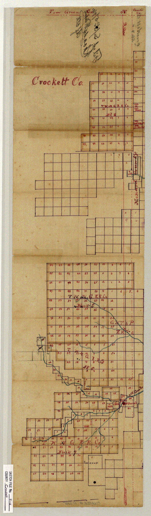
Crockett County Sketch File 4a
[Sketch of T. W. N. G. R.R. Co. Blocks 5, 6, 7, & 8 in Sutton and Schleicher Counties]
-
Map/Doc
11215
-
Collection
General Map Collection
-
Object Dates
9/5/1876 (File Date)
-
Counties
Sutton Schleicher
-
Subjects
Surveying Sketch File
-
Height x Width
28.1 x 8.2 inches
71.4 x 20.8 cm
-
Medium
paper, manuscript
-
Features
Llano River
Fort Terrell
Part of: General Map Collection
Brazoria County Rolled Sketch 22

Print $20.00
- Digital $50.00
Brazoria County Rolled Sketch 22
1929
Size 28.1 x 40.8 inches
Map/Doc 10715
Angelina County Sketch File 11e

Print $6.00
- Digital $50.00
Angelina County Sketch File 11e
1885
Size 12.7 x 8.2 inches
Map/Doc 12951
Map of the country scouted by Colonels McKenzie and Shafter, Capt. R.P. Wilson and others in the years, 1874 & 1875

Print $20.00
- Digital $50.00
Map of the country scouted by Colonels McKenzie and Shafter, Capt. R.P. Wilson and others in the years, 1874 & 1875
1876
Size 43.0 x 31.8 inches
Map/Doc 62972
Flight Mission No. CLL-1N, Frame 30, Willacy County

Print $20.00
- Digital $50.00
Flight Mission No. CLL-1N, Frame 30, Willacy County
1954
Size 18.4 x 22.2 inches
Map/Doc 87011
Flight Mission No. BQR-22K, Frame 37, Brazoria County

Print $20.00
- Digital $50.00
Flight Mission No. BQR-22K, Frame 37, Brazoria County
1953
Size 18.8 x 22.4 inches
Map/Doc 84121
Montgomery County Working Sketch Graphic Index, Sheet 1 (Sketches 1 to 35)

Print $40.00
- Digital $50.00
Montgomery County Working Sketch Graphic Index, Sheet 1 (Sketches 1 to 35)
1943
Size 43.0 x 51.9 inches
Map/Doc 76646

Flight Mission No. BRA-7M, Frame 32, Jefferson County

Print $20.00
- Digital $50.00
Flight Mission No. BRA-7M, Frame 32, Jefferson County
1953
Size 18.7 x 22.4 inches
Map/Doc 85483
Map of Asia (Inset: Palestine)

Print $20.00
- Digital $50.00
Map of Asia (Inset: Palestine)
1844
Size 12.1 x 19.0 inches
Map/Doc 93548
Travis County Rolled Sketch 47

Print $40.00
- Digital $50.00
Travis County Rolled Sketch 47
1925
Size 24.9 x 56.8 inches
Map/Doc 10016
Kinney County Sketch File A1

Print $38.00
- Digital $50.00
Kinney County Sketch File A1
1905
Size 35.4 x 27.6 inches
Map/Doc 11952
Lee County Working Sketch 7

Print $20.00
- Digital $50.00
Lee County Working Sketch 7
1977
Size 27.0 x 16.8 inches
Map/Doc 70386
You may also like
Ellis County Sketch File 16

Print $4.00
- Digital $50.00
Ellis County Sketch File 16
Size 13.1 x 8.3 inches
Map/Doc 21858
[Part of Block GG and river sections 65-75]
![90469, [Part of Block GG and river sections 65-75], Twichell Survey Records](https://historictexasmaps.com/wmedia_w700/maps/90469-1.tif.jpg)
Print $20.00
- Digital $50.00
[Part of Block GG and river sections 65-75]
Size 21.9 x 20.2 inches
Map/Doc 90469
Medina County Rolled Sketch 15

Print $20.00
- Digital $50.00
Medina County Rolled Sketch 15
1980
Size 25.2 x 20.3 inches
Map/Doc 6749
Map of Grimes County

Print $20.00
- Digital $50.00
Map of Grimes County
1881
Size 29.9 x 16.3 inches
Map/Doc 3606
Childress County Rolled Sketch 16A

Print $20.00
- Digital $50.00
Childress County Rolled Sketch 16A
Size 44.3 x 36.9 inches
Map/Doc 8599
Flight Mission No. DCL-7C, Frame 114, Kenedy County

Print $20.00
- Digital $50.00
Flight Mission No. DCL-7C, Frame 114, Kenedy County
1943
Size 18.6 x 22.2 inches
Map/Doc 86079
Cass County Working Sketch 2

Print $20.00
- Digital $50.00
Cass County Working Sketch 2
1935
Size 24.7 x 36.7 inches
Map/Doc 67905
Presidio County Working Sketch 47

Print $20.00
- Digital $50.00
Presidio County Working Sketch 47
1950
Size 30.2 x 39.5 inches
Map/Doc 71724
[Strip map showing F. W. & D. C. RR. line from New Mexico border to Dallam-Hartley County Line]
![93147, [Strip map showing F. W. & D. C. RR. line from New Mexico border to Dallam-Hartley County Line], Twichell Survey Records](https://historictexasmaps.com/wmedia_w700/maps/93147-1.tif.jpg)
Print $40.00
- Digital $50.00
[Strip map showing F. W. & D. C. RR. line from New Mexico border to Dallam-Hartley County Line]
Size 105.5 x 20.9 inches
Map/Doc 93147
Ward County Rolled Sketch 29

Print $20.00
- Digital $50.00
Ward County Rolled Sketch 29
Size 31.8 x 27.4 inches
Map/Doc 89287
Mills County Working Sketch 4

Print $3.00
- Digital $50.00
Mills County Working Sketch 4
1906
Size 10.7 x 11.7 inches
Map/Doc 71034
Grayson County Working Sketch 1

Print $20.00
- Digital $50.00
Grayson County Working Sketch 1
1939
Size 10.8 x 17.7 inches
Map/Doc 63240