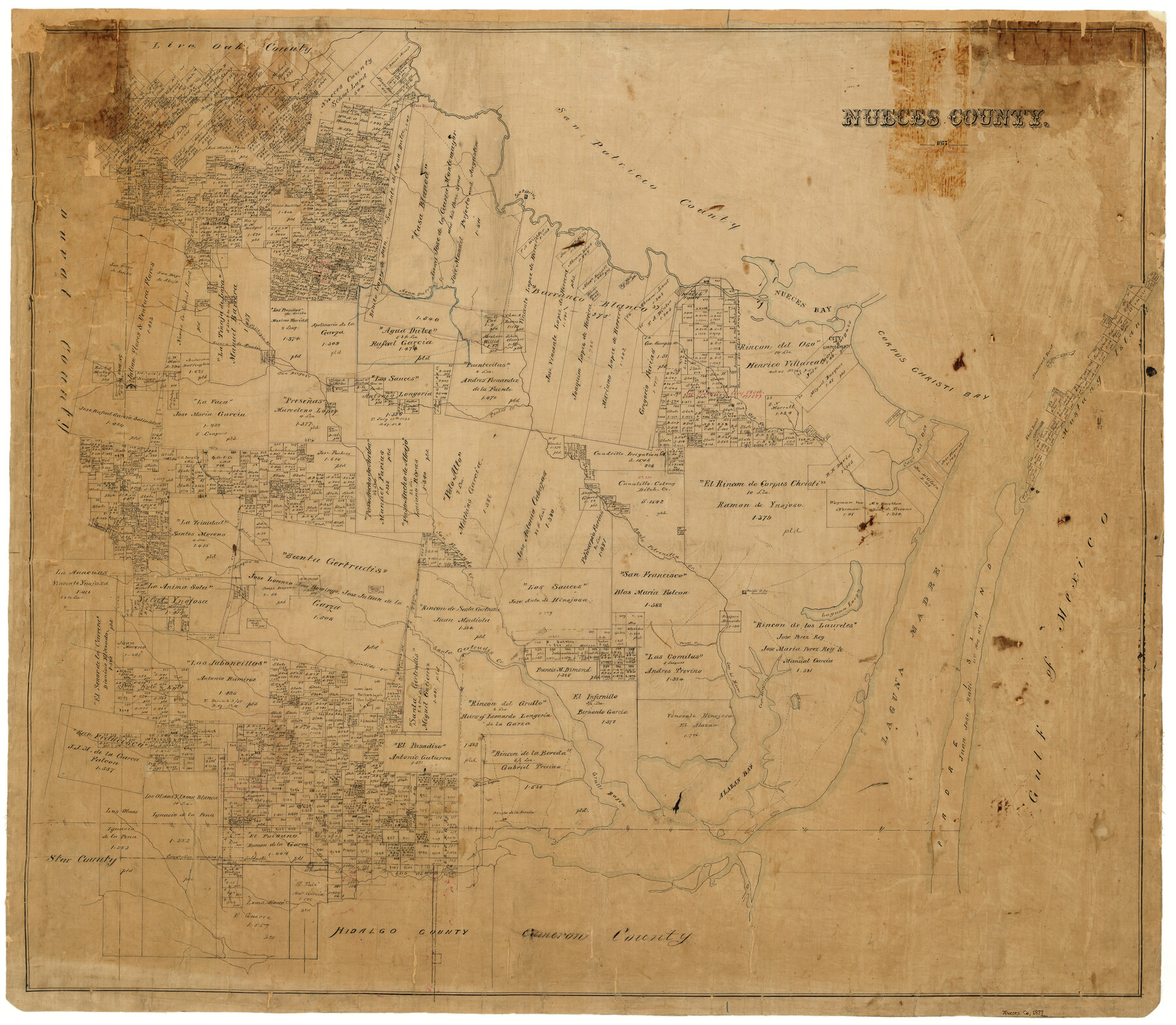
Nueces County
-
Map/Doc
5023
-
Collection
General Map Collection
-
Object Dates
1877 (Creation Date)
-
People and Organizations
Texas General Land Office (Publisher)
William L. Thomson (Draftsman)
William L. Thomson (Compiler)
-
Counties
Nueces
-
Subjects
County
-
Height x Width
33.9 x 39.1 inches
86.1 x 99.3 cm
Part of: General Map Collection
Brewster County Sketch File S-2

Print $16.00
- Digital $50.00
Brewster County Sketch File S-2
1910
Size 17.0 x 11.0 inches
Map/Doc 15731
Red River County Working Sketch 53

Print $20.00
- Digital $50.00
Red River County Working Sketch 53
1971
Size 23.4 x 26.9 inches
Map/Doc 72036
Madison County Working Sketch 10

Print $20.00
- Digital $50.00
Madison County Working Sketch 10
1960
Size 34.7 x 32.0 inches
Map/Doc 70772
Hidalgo County Rolled Sketch 16

Print $40.00
- Digital $50.00
Hidalgo County Rolled Sketch 16
1963
Size 68.9 x 42.2 inches
Map/Doc 9171
Ellis County Boundary File 3a

Print $10.00
- Digital $50.00
Ellis County Boundary File 3a
Size 11.2 x 8.9 inches
Map/Doc 52960
Flight Mission No. CRC-4R, Frame 152, Chambers County

Print $20.00
- Digital $50.00
Flight Mission No. CRC-4R, Frame 152, Chambers County
1956
Size 18.8 x 22.4 inches
Map/Doc 84915
Presidio County Rolled Sketch 71

Print $20.00
- Digital $50.00
Presidio County Rolled Sketch 71
1941
Size 31.7 x 42.9 inches
Map/Doc 7361

San Augustine County Sketch File 12

Print $4.00
San Augustine County Sketch File 12
Size 12.2 x 7.9 inches
Map/Doc 35656
Rusk County Sketch File 27a

Print $10.00
Rusk County Sketch File 27a
1936
Size 14.2 x 8.8 inches
Map/Doc 35532
Map of Newton County

Print $40.00
- Digital $50.00
Map of Newton County
1894
Size 74.9 x 27.7 inches
Map/Doc 16778
McLennan County Sketch File 2

Print $6.00
- Digital $50.00
McLennan County Sketch File 2
1856
Size 11.5 x 7.7 inches
Map/Doc 31230
You may also like
Sectional map of Central and Eastern Texas traversed by the Missouri, Kansas & Texas Railway, showing the crops adapted to each section, with the elevation and average annual rainfall

Print $20.00
- Digital $50.00
Sectional map of Central and Eastern Texas traversed by the Missouri, Kansas & Texas Railway, showing the crops adapted to each section, with the elevation and average annual rainfall
1902
Size 19.7 x 16.2 inches
Map/Doc 95812

Crockett County Working Sketch 82

Print $40.00
- Digital $50.00
Crockett County Working Sketch 82
1973
Size 34.9 x 49.7 inches
Map/Doc 68415
[Heirs of Jno. Breeding and surrounding surveys]
![90494, [Heirs of Jno. Breeding and surrounding surveys], Twichell Survey Records](https://historictexasmaps.com/wmedia_w700/maps/90494-1.tif.jpg)
Print $3.00
- Digital $50.00
[Heirs of Jno. Breeding and surrounding surveys]
Size 10.5 x 16.1 inches
Map/Doc 90494
University Land Block 46, Culberson County, Texas

Print $20.00
- Digital $50.00
University Land Block 46, Culberson County, Texas
1938
Size 35.1 x 22.0 inches
Map/Doc 2410
Bowie County Working Sketch 17

Print $20.00
- Digital $50.00
Bowie County Working Sketch 17
1962
Size 24.5 x 20.0 inches
Map/Doc 67421
Dickens County Rolled Sketch 13

Print $40.00
- Digital $50.00
Dickens County Rolled Sketch 13
1950
Size 43.4 x 53.7 inches
Map/Doc 45135
Crockett County Sketch File 35d

Print $10.00
- Digital $50.00
Crockett County Sketch File 35d
Size 14.2 x 8.9 inches
Map/Doc 19750
The Republic County of Gonzales. Boundaries Defined, December 14, 1837

Print $20.00
The Republic County of Gonzales. Boundaries Defined, December 14, 1837
2020
Size 14.7 x 21.7 inches
Map/Doc 96153
Texas Intracoastal Waterway - Stover Point to Port Brownsville including Brazos Santiago

Print $20.00
- Digital $50.00
Texas Intracoastal Waterway - Stover Point to Port Brownsville including Brazos Santiago
1965
Size 27.5 x 38.9 inches
Map/Doc 73521
Jeff Davis County Rolled Sketch 45

Print $40.00
- Digital $50.00
Jeff Davis County Rolled Sketch 45
2005
Size 91.3 x 44.0 inches
Map/Doc 87207
Grayson County Working Sketch 24

Print $20.00
- Digital $50.00
Grayson County Working Sketch 24
1977
Size 34.5 x 42.1 inches
Map/Doc 63263