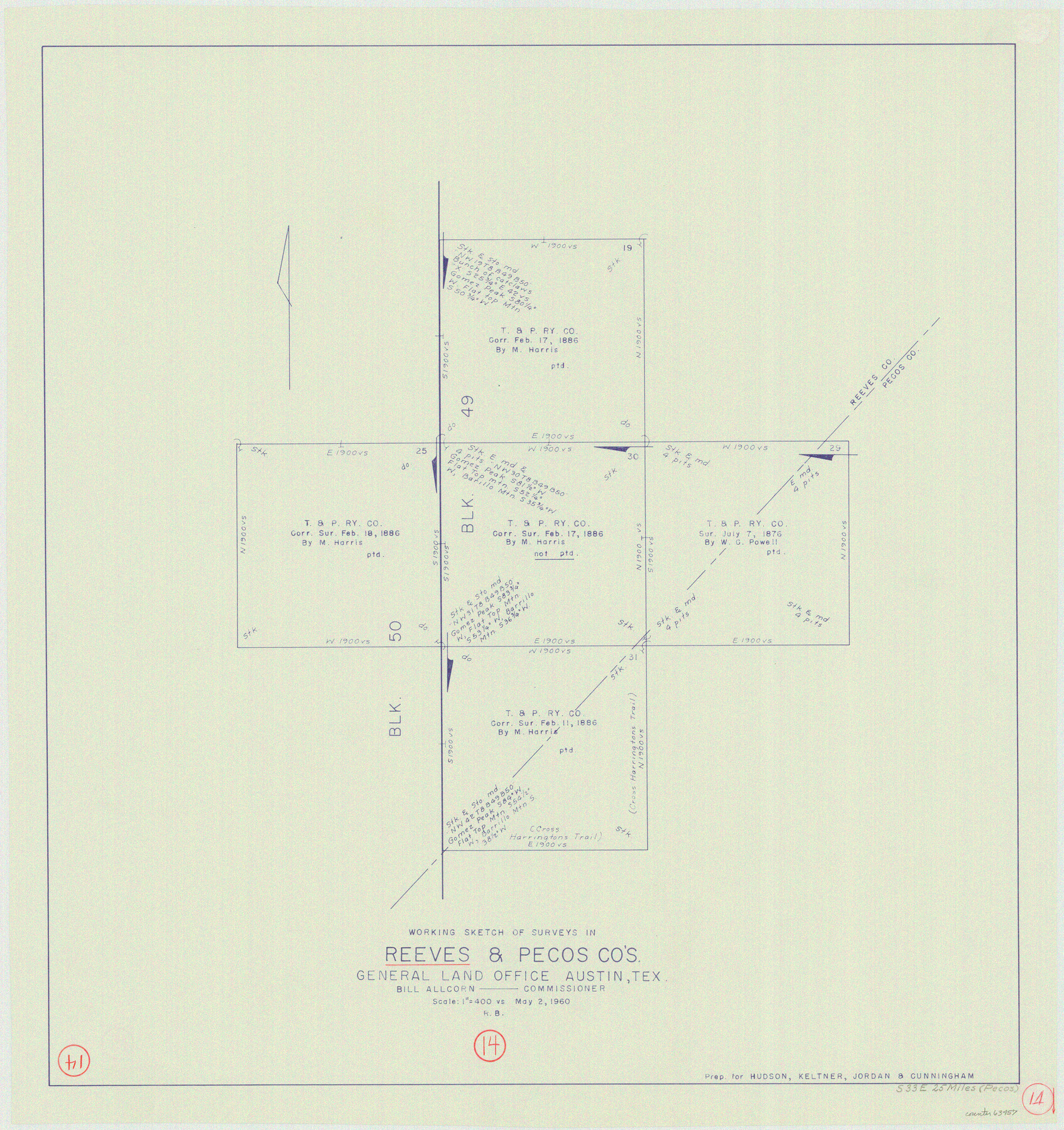
Reeves County Working Sketch 14
-
Map/Doc
63457
-
Collection
General Map Collection
-
Object Dates
5/2/1960 (Creation Date)
-
People and Organizations
Roy Buckholts (Draftsman)
-
Counties
Reeves Pecos
-
Subjects
Surveying Working Sketch
-
Height x Width
26.5 x 24.9 inches
67.3 x 63.3 cm
-
Scale
1" = 400 varas
Part of: General Map Collection
Padre Island Under Six Flags

Print $40.00
- Digital $50.00
Padre Island Under Six Flags
1962
Size 59.3 x 30.3 inches
Map/Doc 3123
Wheeler County Boundary File 93

Print $64.00
- Digital $50.00
Wheeler County Boundary File 93
Size 9.4 x 5.1 inches
Map/Doc 59872
Montague County Working Sketch 5

Print $20.00
- Digital $50.00
Montague County Working Sketch 5
1920
Size 24.9 x 20.9 inches
Map/Doc 71071
Jefferson County Rolled Sketch 25

Print $20.00
- Digital $50.00
Jefferson County Rolled Sketch 25
1939
Size 43.4 x 36.0 inches
Map/Doc 9290
Karnes County Sketch File 7

Print $10.00
- Digital $50.00
Karnes County Sketch File 7
1863
Size 10.6 x 8.2 inches
Map/Doc 28559
Wichita County Rolled Sketch 9

Print $20.00
- Digital $50.00
Wichita County Rolled Sketch 9
1917
Size 28.0 x 27.7 inches
Map/Doc 8246
Brazoria County Working Sketch 27

Print $20.00
- Digital $50.00
Brazoria County Working Sketch 27
1970
Size 41.8 x 32.5 inches
Map/Doc 67512
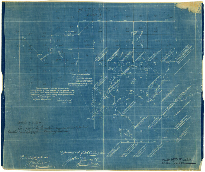
Brewster County Rolled Sketch 24E
Print $20.00
- Digital $50.00
Brewster County Rolled Sketch 24E
1906
Size 15.2 x 18.1 inches
Map/Doc 5212
Texas, Intracoastal Waterway, Ayres Bay to Aransas Bay

Print $40.00
- Digital $50.00
Texas, Intracoastal Waterway, Ayres Bay to Aransas Bay
1934
Size 33.2 x 48.5 inches
Map/Doc 69997
Texas Coast, No. 17

Print $20.00
- Digital $50.00
Texas Coast, No. 17
Size 18.3 x 26.1 inches
Map/Doc 72713
McCulloch County Working Sketch 11

Print $20.00
- Digital $50.00
McCulloch County Working Sketch 11
1983
Size 35.1 x 43.3 inches
Map/Doc 70686

You may also like
Wichita County Working Sketch 20

Print $20.00
- Digital $50.00
Wichita County Working Sketch 20
1950
Size 33.2 x 23.0 inches
Map/Doc 72530
Harris County Rolled Sketch R

Print $40.00
- Digital $50.00
Harris County Rolled Sketch R
1915
Size 20.3 x 93.8 inches
Map/Doc 9114
San Patricio County Sketch File 54

Print $86.00
- Digital $50.00
San Patricio County Sketch File 54
1997
Size 11.0 x 8.5 inches
Map/Doc 41769
Cameron County Rolled Sketch US2

Print $168.00
- Digital $50.00
Cameron County Rolled Sketch US2
1913
Size 10.4 x 16.3 inches
Map/Doc 43804
Navigation Maps of Gulf Intracoastal Waterway, Port Arthur to Brownsville, Texas

Print $20.00
- Digital $50.00
Navigation Maps of Gulf Intracoastal Waterway, Port Arthur to Brownsville, Texas
1951
Size 16.7 x 21.4 inches
Map/Doc 65417
Jefferson County Working Sketch 15

Print $20.00
- Digital $50.00
Jefferson County Working Sketch 15
1953
Size 24.5 x 28.6 inches
Map/Doc 66558
Borden County Boundary File 5a

Print $98.00
- Digital $50.00
Borden County Boundary File 5a
Size 13.3 x 8.1 inches
Map/Doc 50659
Haskell County Sketch File 9

Print $30.00
- Digital $50.00
Haskell County Sketch File 9
Size 23.2 x 14.9 inches
Map/Doc 26130
Hutchinson County Rolled Sketch 9

Print $20.00
- Digital $50.00
Hutchinson County Rolled Sketch 9
Size 25.5 x 27.8 inches
Map/Doc 6280
Cottle County Sketch File 6

Print $20.00
- Digital $50.00
Cottle County Sketch File 6
1883
Size 20.3 x 29.8 inches
Map/Doc 11190
[Map of Polk County]
![4613, [Map of Polk County], General Map Collection](https://historictexasmaps.com/wmedia_w700/maps/4613-1.tif.jpg)
Print $20.00
- Digital $50.00
[Map of Polk County]
1855
Size 21.2 x 31.0 inches
Map/Doc 4613
Hardin County

Print $40.00
- Digital $50.00
Hardin County
1940
Size 48.8 x 44.3 inches
Map/Doc 95521