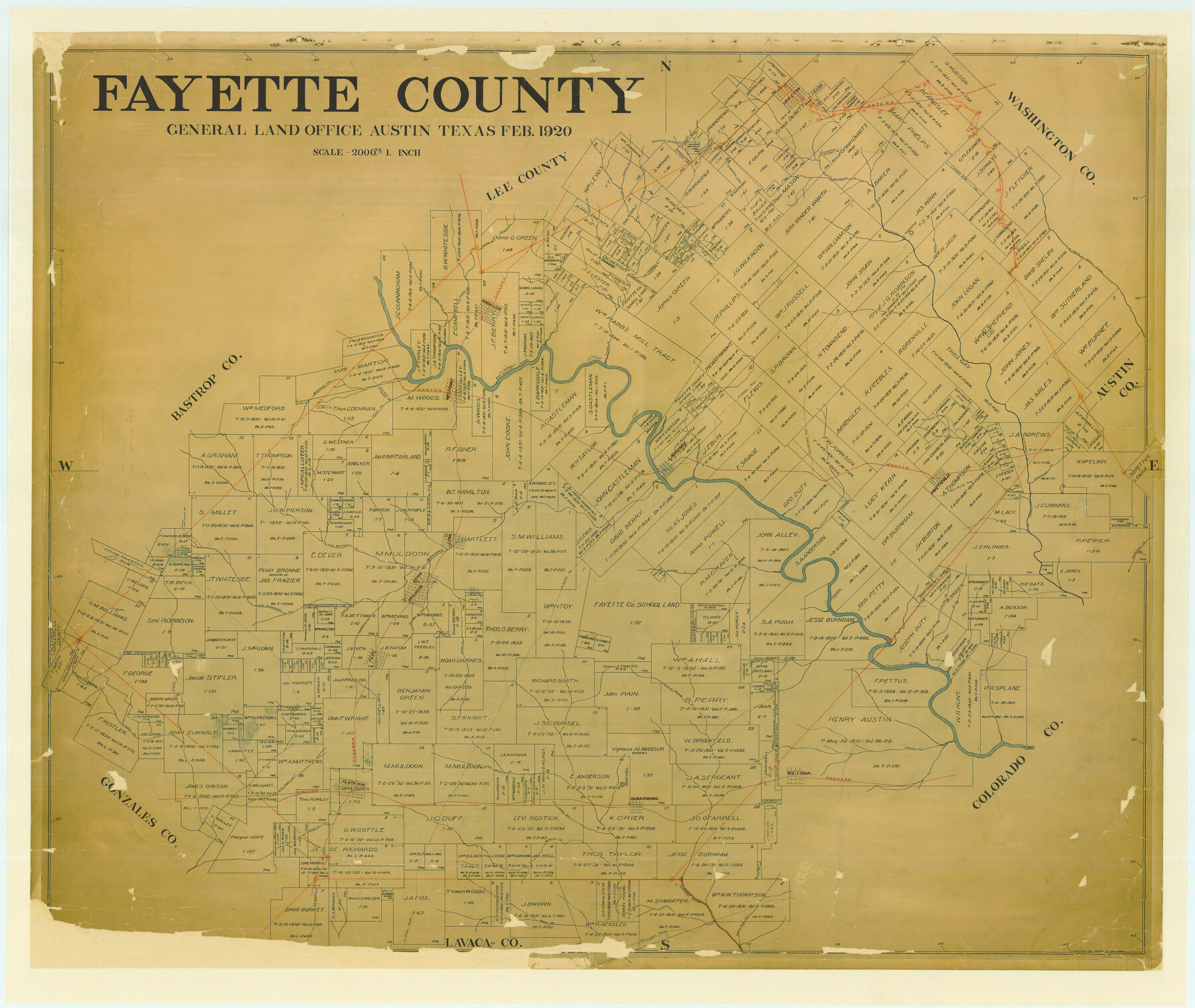
Fayette County
-
Map/Doc
4716
-
Collection
General Map Collection
-
Object Dates
1920 (Creation Date)
-
People and Organizations
Texas General Land Office (Publisher)
Tom G. Atlee (Draftsman)
Tom G. Atlee (Compiler)
-
Counties
Fayette
-
Subjects
County
-
Height x Width
40.7 x 49.0 inches
103.4 x 124.5 cm
-
Comments
Adopted and conservation funded in 2006 by Dr. John G. Looney, Durham, North Carolina and Dan von Rosenberg, La Grange, Texas.
-
Features
Pin Oak Fork of Navidad River
Upper Rocky Creek
Harvey's Creek
Brushey [sic] Creek
Main Fork of Navidad River
Peach Creek
Burleson Road
Lockhart Road
South Fork of Buckner's Creek
Mesquite Creek
Dogwood Creek
Boggy Creek
Buckner's Creek
William's Creek
Burnham's Crossing
Criers Creek
Redgates Creek
Port Lavaca Road
Austin to Port Lavaca Road
La Grange
Cedar Creek
La Bahia Road
Floy
Pin Oak Fork of Buckner's Creek
Lena
North Branch of Buckner's Creek
Wilbarger Road
Smithville to Flatonia Road
Flatonia Road
Smithville Road
Water Hole Creek
Gonzales Road
Fayetteville
La Vaca [sic] River
Navidad River
High Hill
Schulenburg
Sandy Fork of Rocky Creek
Mulberry Creek
GH&SA
East Fork of Peach Creek
Weimar
H&TC
East Prong of Pin Oak Creek
West Prong of Pin Oak Creek
North Prong of Pin Oak Creek
Prairie Branch of Pin Oak Creek
Kubitz's Creek
Rabb's Creek
David's Creek
Pin Oak Creek
Willbarger Trace
Williamson's Creek
SA&AP
Ledbetter
Greens Creek
Washington to Bastrop Road
Bastrop Road
Washington Road
Lena
Dunn
Muldoon
Floy
Bastrop to La Grange Road
Ross to Pettus Road
Pettus Road
Ross Road
St. Barnabas Creek
Percimmon [sic] Creek
San Felipe Road
Colorado River
West Point
MK&T
Flatonia
La Grange Road
Bartons Creek
West Prong of Mill Creek
First Falls
Rocky Creek
Round Top
Cummins Creek
Owl Creek
Winchester
Part of: General Map Collection
Flight Mission No. BQR-3K, Frame 162, Brazoria County

Print $20.00
- Digital $50.00
Flight Mission No. BQR-3K, Frame 162, Brazoria County
1952
Size 18.7 x 22.4 inches
Map/Doc 83989
San Augustine County Sketch File 9

Print $4.00
San Augustine County Sketch File 9
1860
Size 12.6 x 7.6 inches
Map/Doc 35650
Map of the Texas & Pacific Ry. Reserve West of the Pecos River

Print $20.00
- Digital $50.00
Map of the Texas & Pacific Ry. Reserve West of the Pecos River
1879
Size 40.8 x 30.2 inches
Map/Doc 65333
Flight Mission No. DIX-10P, Frame 178, Aransas County

Print $20.00
- Digital $50.00
Flight Mission No. DIX-10P, Frame 178, Aransas County
1956
Size 18.5 x 22.2 inches
Map/Doc 83968
Dawson County Working Sketch 1

Print $20.00
- Digital $50.00
Dawson County Working Sketch 1
Size 11.1 x 14.1 inches
Map/Doc 68545
Sutton County Sketch File 28

Print $46.00
- Digital $50.00
Sutton County Sketch File 28
1934
Size 37.2 x 17.9 inches
Map/Doc 12385
Throckmorton County Sketch File 7a

Print $6.00
- Digital $50.00
Throckmorton County Sketch File 7a
1898
Size 13.9 x 6.7 inches
Map/Doc 38094
Flight Mission No. DQN-2K, Frame 99, Calhoun County

Print $20.00
- Digital $50.00
Flight Mission No. DQN-2K, Frame 99, Calhoun County
1953
Size 18.7 x 22.3 inches
Map/Doc 84289
Map of the Hearne and Brazos Valley Railroad from Mumford to Moseley's Ferry

Print $40.00
- Digital $50.00
Map of the Hearne and Brazos Valley Railroad from Mumford to Moseley's Ferry
1892
Size 20.0 x 56.8 inches
Map/Doc 64400
Roberts County Working Sketch 11

Print $40.00
- Digital $50.00
Roberts County Working Sketch 11
1966
Size 57.6 x 38.6 inches
Map/Doc 63537
Lynn County Rolled Sketch W

Print $20.00
- Digital $50.00
Lynn County Rolled Sketch W
Size 23.0 x 40.0 inches
Map/Doc 6655
Galveston County NRC Article 33.136 Sketch 77

Print $44.00
- Digital $50.00
Galveston County NRC Article 33.136 Sketch 77
2015
Size 24.0 x 36.0 inches
Map/Doc 94991
You may also like
El Paso County Rolled Sketch 43B

Print $20.00
- Digital $50.00
El Paso County Rolled Sketch 43B
Size 22.0 x 22.0 inches
Map/Doc 5830
Close-up: USA - The South Central States

Close-up: USA - The South Central States
1974
Size 23.2 x 35.2 inches
Map/Doc 96846
Haskell County Working Sketch 1

Print $40.00
- Digital $50.00
Haskell County Working Sketch 1
Size 31.0 x 74.5 inches
Map/Doc 66059
Cameron County Rolled Sketch 32

Print $40.00
- Digital $50.00
Cameron County Rolled Sketch 32
1981
Size 136.6 x 18.1 inches
Map/Doc 8579
Duval County Working Sketch 13

Print $20.00
- Digital $50.00
Duval County Working Sketch 13
1938
Size 27.8 x 32.5 inches
Map/Doc 68726
Texas Population Distribution in Cities, per the U.S. Census of 1910

Texas Population Distribution in Cities, per the U.S. Census of 1910
2022
Size 11.0 x 8.5 inches
Map/Doc 97092
Sketch No. 1, Dickens & Motley Cos.

Print $20.00
- Digital $50.00
Sketch No. 1, Dickens & Motley Cos.
1879
Size 17.9 x 15.5 inches
Map/Doc 10761
Nueces River, Bluntzer Sheet

Print $20.00
- Digital $50.00
Nueces River, Bluntzer Sheet
1927
Size 35.3 x 42.9 inches
Map/Doc 65088
Presidio County Working Sketch 85

Print $20.00
- Digital $50.00
Presidio County Working Sketch 85
1970
Size 37.0 x 30.8 inches
Map/Doc 71762
Comal County Working Sketch 18

Print $20.00
- Digital $50.00
Comal County Working Sketch 18
2000
Size 32.0 x 31.7 inches
Map/Doc 68182
Lampasas County Working Sketch 8

Print $20.00
- Digital $50.00
Lampasas County Working Sketch 8
1958
Size 36.4 x 37.1 inches
Map/Doc 70285
Webb County Sketch File 13a

Print $20.00
- Digital $50.00
Webb County Sketch File 13a
1881
Size 19.0 x 25.7 inches
Map/Doc 12631