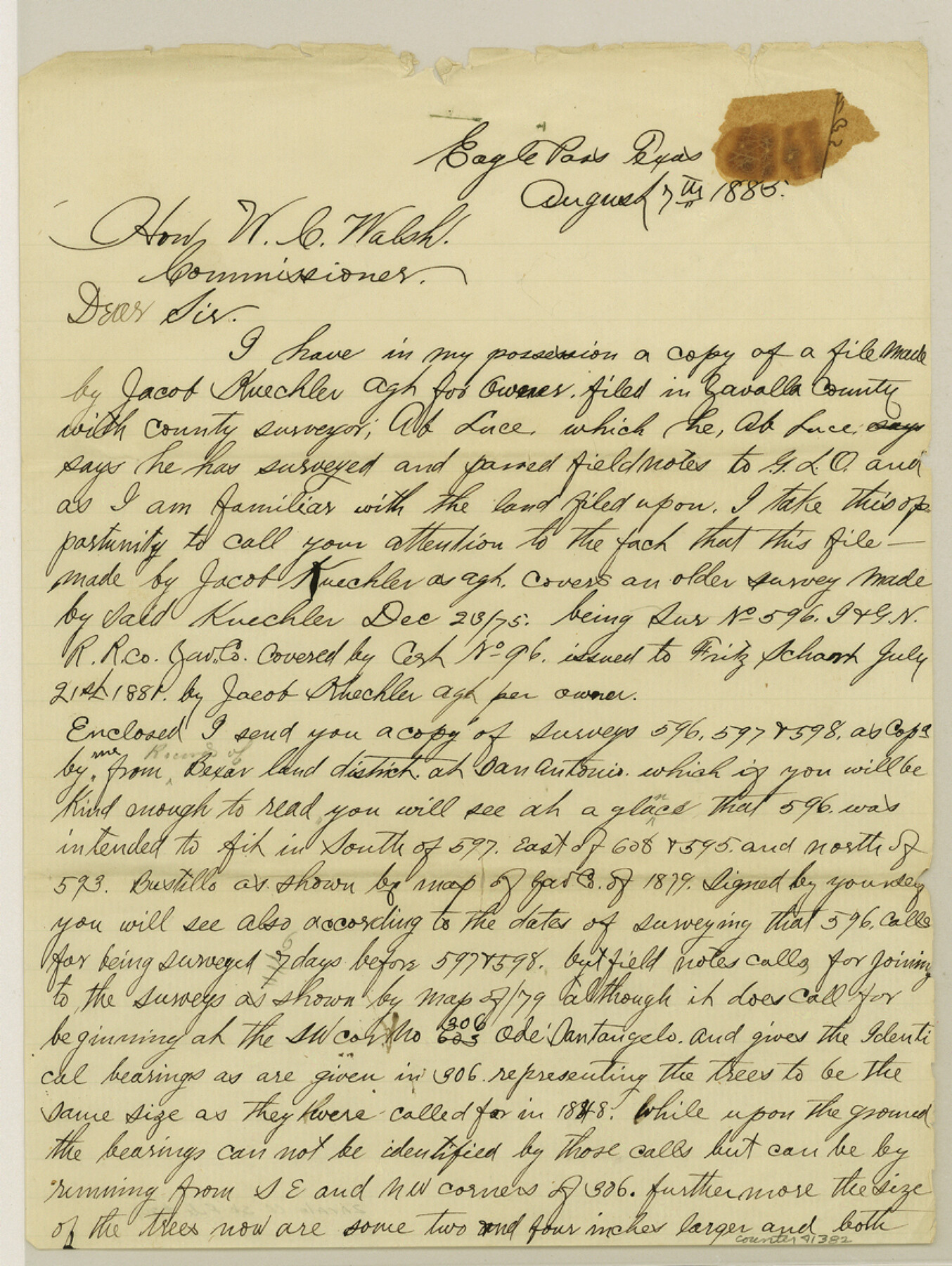
Zavala County Sketch File 24
[Explanation and copies of field notes regarding surveys 596, 597, and 598 near the west line of Zavala County]
-
Map/Doc
41382
-
Collection
General Map Collection
-
Object Dates
8/7/1885 (Creation Date)
8/20/1885 (File Date)
12/23/1875 (Survey Date)
12/29/1875 (Survey Date)
-
People and Organizations
Jacob Kuechler (Surveyor/Engineer)
O.H. Hector (Surveyor/Engineer)
L.C. Navarro (Surveyor/Engineer)
-
Counties
Zavala Maverick
-
Subjects
Surveying Sketch File
-
Height x Width
11.5 x 8.6 inches
29.2 x 21.8 cm
-
Medium
paper, manuscript
Part of: General Map Collection
Gonzales County

Print $20.00
- Digital $50.00
Gonzales County
1880
Size 25.3 x 22.6 inches
Map/Doc 3594
Railroad Track Map, H&TCRRCo., Falls County, Texas

Print $4.00
- Digital $50.00
Railroad Track Map, H&TCRRCo., Falls County, Texas
1918
Size 11.7 x 18.5 inches
Map/Doc 62833
[Cotton Belt, St. Louis Southwestern Railway of Texas, Alignment through Smith County]
![64382, [Cotton Belt, St. Louis Southwestern Railway of Texas, Alignment through Smith County], General Map Collection](https://historictexasmaps.com/wmedia_w700/maps/64382.tif.jpg)
Print $20.00
- Digital $50.00
[Cotton Belt, St. Louis Southwestern Railway of Texas, Alignment through Smith County]
1903
Size 21.8 x 29.1 inches
Map/Doc 64382
Cameron County Aerial Photograph Index Sheet 7

Print $20.00
- Digital $50.00
Cameron County Aerial Photograph Index Sheet 7
1955
Size 21.8 x 16.2 inches
Map/Doc 83679
Houston County Working Sketch 9

Print $20.00
- Digital $50.00
Houston County Working Sketch 9
1939
Size 28.9 x 31.3 inches
Map/Doc 66239
Flight Mission No. DIX-8P, Frame 68, Aransas County

Print $20.00
- Digital $50.00
Flight Mission No. DIX-8P, Frame 68, Aransas County
1956
Size 18.7 x 22.5 inches
Map/Doc 83899
Matagorda County Rolled Sketch 39

Print $40.00
- Digital $50.00
Matagorda County Rolled Sketch 39
1973
Size 24.4 x 114.0 inches
Map/Doc 10743
La Salle County Sketch File 23

Print $40.00
- Digital $50.00
La Salle County Sketch File 23
Size 14.2 x 17.3 inches
Map/Doc 29530
Tarrant County Working Sketch Graphic Index

Print $20.00
- Digital $50.00
Tarrant County Working Sketch Graphic Index
1942
Size 44.0 x 35.8 inches
Map/Doc 76708
Upton County Sketch File 22

Print $4.00
- Digital $50.00
Upton County Sketch File 22
1927
Size 11.2 x 8.5 inches
Map/Doc 38877
Asher & Adams' Geological Map - United States and Territories

Print $20.00
- Digital $50.00
Asher & Adams' Geological Map - United States and Territories
1874
Size 17.9 x 24.9 inches
Map/Doc 95175
Aransas County Sketch File 24

Print $36.00
- Digital $50.00
Aransas County Sketch File 24
1938
Size 10.9 x 8.3 inches
Map/Doc 13177
You may also like
Map of Shackelford County, Texas

Print $20.00
- Digital $50.00
Map of Shackelford County, Texas
1879
Size 28.7 x 23.4 inches
Map/Doc 616
Aransas County NRC Article 33.136 Sketch 11

Print $54.00
- Digital $50.00
Aransas County NRC Article 33.136 Sketch 11
2012
Size 36.0 x 48.0 inches
Map/Doc 94502
McMullen County Working Sketch 59

Print $20.00
- Digital $50.00
McMullen County Working Sketch 59
1984
Size 24.0 x 27.7 inches
Map/Doc 70760
Taylor County Working Sketch 18

Print $20.00
- Digital $50.00
Taylor County Working Sketch 18
1985
Size 43.2 x 46.0 inches
Map/Doc 69628
Bexar County Sketch File 30

Print $8.00
- Digital $50.00
Bexar County Sketch File 30
1867
Size 9.5 x 8.2 inches
Map/Doc 14492
Kinney County Rolled Sketch 3

Print $20.00
- Digital $50.00
Kinney County Rolled Sketch 3
Size 31.4 x 23.2 inches
Map/Doc 6535
![90567, [Block M], Twichell Survey Records](https://historictexasmaps.com/wmedia_w700/maps/90567-1.tif.jpg)
Van Zandt County Sketch File 25

Print $4.00
- Digital $50.00
Van Zandt County Sketch File 25
Size 7.6 x 8.8 inches
Map/Doc 39443
General Highway Map Cochran County, Texas

Print $40.00
- Digital $50.00
General Highway Map Cochran County, Texas
1942
Size 37.4 x 50.1 inches
Map/Doc 89851
Jasper County Sketch File 23

Print $20.00
- Digital $50.00
Jasper County Sketch File 23
Size 15.3 x 24.6 inches
Map/Doc 11850
Newton County Sketch File 4c

Print $4.00
- Digital $50.00
Newton County Sketch File 4c
Size 7.4 x 8.2 inches
Map/Doc 32366
Loving County Rolled Sketch 14

Print $20.00
- Digital $50.00
Loving County Rolled Sketch 14
2006
Size 11.4 x 17.5 inches
Map/Doc 93381