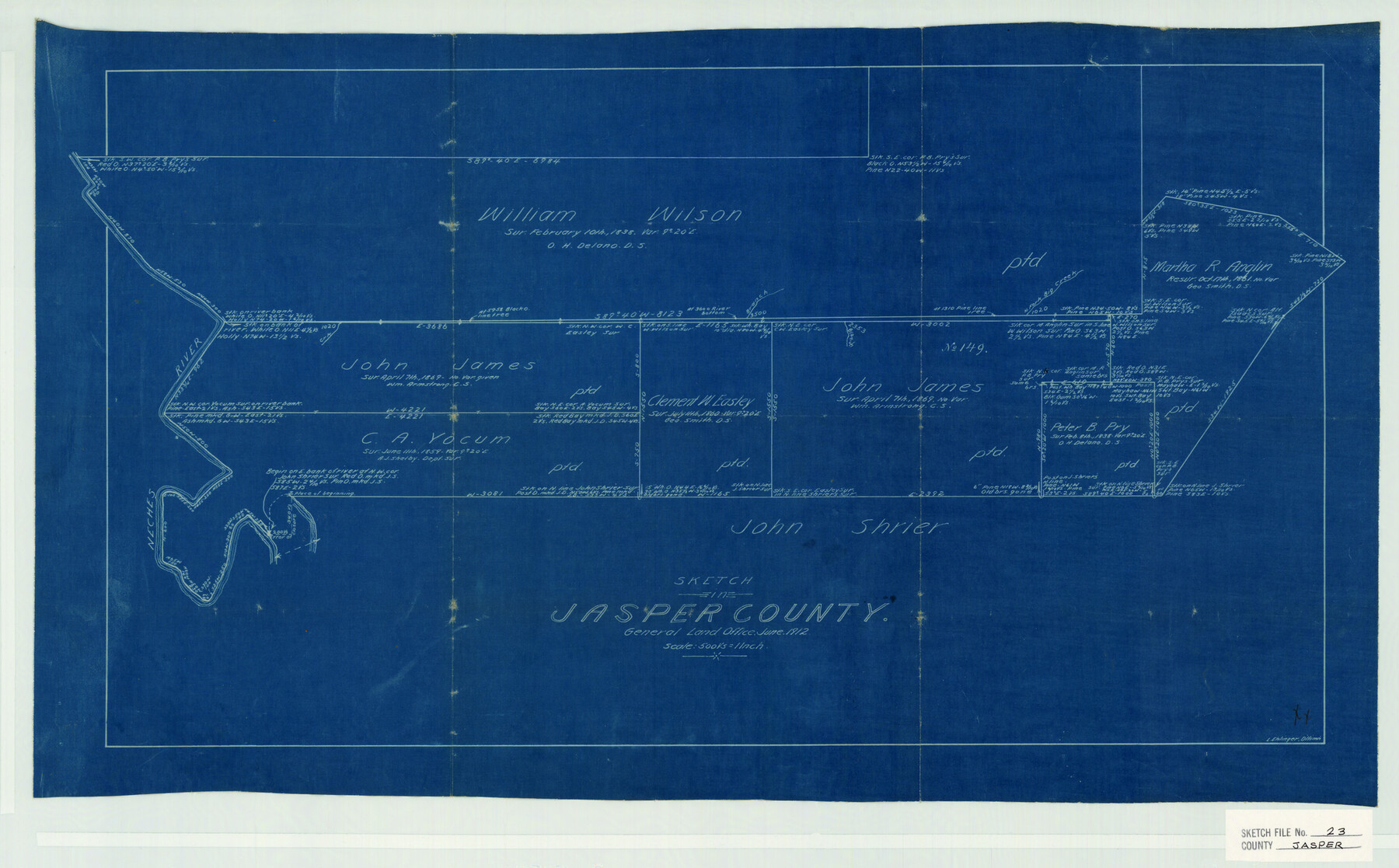
Jasper County Sketch File 23
Leo Ehlinger's Wk. Sk. Of tracts around the John James Sur.
-
Map/Doc
11850
-
Collection
General Map Collection
-
People and Organizations
Ehlenger (Surveyor/Engineer)
-
Counties
Jasper
-
Subjects
Surveying Sketch File
-
Height x Width
15.3 x 24.6 inches
38.9 x 62.5 cm
-
Medium
blueprint/diazo
-
Scale
1:500
-
Features
West Fork of Big Creek
Neches River
Part of: General Map Collection
Val Verde County Working Sketch 96

Print $20.00
- Digital $50.00
Val Verde County Working Sketch 96
1979
Size 38.9 x 36.9 inches
Map/Doc 72231
Flight Mission No. DAH-9M, Frame 202, Orange County

Print $20.00
- Digital $50.00
Flight Mission No. DAH-9M, Frame 202, Orange County
1953
Size 18.5 x 22.6 inches
Map/Doc 86870
Presidio County Rolled Sketch 26

Print $20.00
- Digital $50.00
Presidio County Rolled Sketch 26
1886
Size 33.9 x 26.9 inches
Map/Doc 7333
Colorado County Rolled Sketch 3

Print $20.00
- Digital $50.00
Colorado County Rolled Sketch 3
1943
Size 43.6 x 40.2 inches
Map/Doc 8642
Limestone County Sketch File 15

Print $8.00
- Digital $50.00
Limestone County Sketch File 15
1883
Size 12.7 x 8.0 inches
Map/Doc 30181
Map of Eastland County, the portion on the waters of Colorado River, Travis - the balance, Milam Land District

Print $20.00
- Digital $50.00
Map of Eastland County, the portion on the waters of Colorado River, Travis - the balance, Milam Land District
1860
Size 23.8 x 21.5 inches
Map/Doc 3501
Midland County Sketch File D

Print $42.00
- Digital $50.00
Midland County Sketch File D
1901
Size 32.6 x 18.4 inches
Map/Doc 12089
Bastrop County

Print $20.00
- Digital $50.00
Bastrop County
1872
Size 21.1 x 17.4 inches
Map/Doc 3279
Carta Etnografica

Print $20.00
- Digital $50.00
Carta Etnografica
1897
Size 26.2 x 34.1 inches
Map/Doc 96798
Photo Index of Texas Coast - Sheet 2 of 6

Print $20.00
- Digital $50.00
Photo Index of Texas Coast - Sheet 2 of 6
1954
Size 20.0 x 24.0 inches
Map/Doc 83440
Webb County Sketch File 19

Print $15.00
- Digital $50.00
Webb County Sketch File 19
1902
Size 9.2 x 17.0 inches
Map/Doc 39822
Glasscock County Sketch File 13

Print $20.00
- Digital $50.00
Glasscock County Sketch File 13
1935
Size 18.8 x 17.8 inches
Map/Doc 11562
You may also like
Reeves County Working Sketch 3

Print $20.00
- Digital $50.00
Reeves County Working Sketch 3
1908
Size 18.7 x 23.1 inches
Map/Doc 63445
Mexico and Internal Provinces

Print $20.00
Mexico and Internal Provinces
1822
Size 17.8 x 22.5 inches
Map/Doc 76189

Calhoun County Working Sketch 11

Print $20.00
- Digital $50.00
Calhoun County Working Sketch 11
1952
Size 43.1 x 34.9 inches
Map/Doc 67827
Montgomery County Working Sketch 25

Print $40.00
- Digital $50.00
Montgomery County Working Sketch 25
1941
Size 50.0 x 43.7 inches
Map/Doc 71132
19th Congressional District of Texas

Print $20.00
- Digital $50.00
19th Congressional District of Texas
Size 33.1 x 28.9 inches
Map/Doc 92610
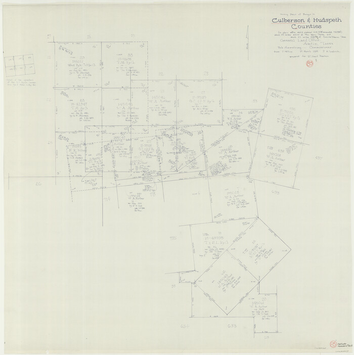
Culberson County Working Sketch 85
Print $20.00
- Digital $50.00
Culberson County Working Sketch 85
1981
Size 37.0 x 36.9 inches
Map/Doc 68539
Jeff Davis County Rolled Sketch 29

Print $20.00
- Digital $50.00
Jeff Davis County Rolled Sketch 29
Size 40.4 x 27.2 inches
Map/Doc 6377
General Highway Map, Kinney County, Uvalde County, Texas

Print $20.00
General Highway Map, Kinney County, Uvalde County, Texas
1961
Size 18.2 x 24.6 inches
Map/Doc 79556
[Map of the Stockdale-Cuero Extension G.H. & S.A. Ry.]
![64096, [Map of the Stockdale-Cuero Extension G.H. & S.A. Ry.], General Map Collection](https://historictexasmaps.com/wmedia_w700/maps/64096.tif.jpg)
Print $40.00
- Digital $50.00
[Map of the Stockdale-Cuero Extension G.H. & S.A. Ry.]
1905
Size 19.4 x 118.2 inches
Map/Doc 64096
Galveston Bay Entrance - Galveston and Texas City Harbors

Print $40.00
- Digital $50.00
Galveston Bay Entrance - Galveston and Texas City Harbors
1982
Size 37.0 x 53.3 inches
Map/Doc 69865
Mills County Rolled Sketch 1

Print $20.00
- Digital $50.00
Mills County Rolled Sketch 1
Size 29.6 x 30.4 inches
Map/Doc 6779