Uvalde County Sketch File 11
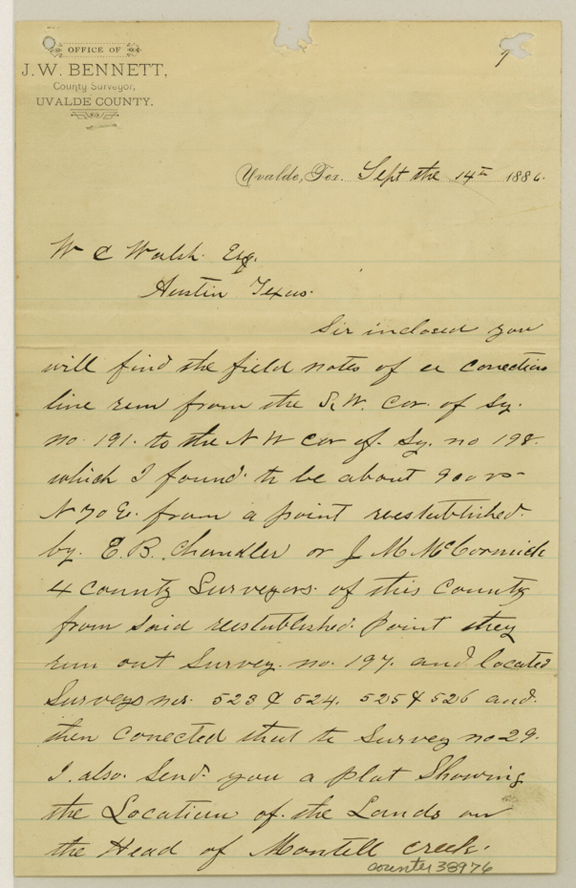
[Sketch and field notes of connecting line from the southwest corner of survey 191 to the northwest corner of survey 198 in the northwest corner of the county]
-
Map/Doc
38972
-
Collection
General Map Collection
-
Object Dates
9/14/1886 (Creation Date)
9/16/1886 (File Date)
2/14/1886 (Survey Date)
-
People and Organizations
John Groose (Chainman/Field Personnel)
D.C. Mitchell (Chainman/Field Personnel)
J.W. Bennett (Surveyor/Engineer)
-
Counties
Uvalde Kinney Edwards
-
Subjects
Surveying Sketch File
-
Height x Width
12.1 x 13.1 inches
30.7 x 33.3 cm
-
Medium
multi-page, multi-format
-
Features
Montell Creek
Cedar Creek
Lake Creek
Black Creek
Nueces River
Part of: General Map Collection
Flight Mission No. CON-2R, Frame 94, Stonewall County

Print $20.00
- Digital $50.00
Flight Mission No. CON-2R, Frame 94, Stonewall County
1957
Size 18.5 x 22.2 inches
Map/Doc 86988
Midland County Sketch File 9

Print $20.00
- Digital $50.00
Midland County Sketch File 9
Size 19.7 x 29.2 inches
Map/Doc 12085
Armstrong County Sketch File A-14

Print $60.00
- Digital $50.00
Armstrong County Sketch File A-14
Size 17.4 x 20.2 inches
Map/Doc 10855
Real County Working Sketch 26

Print $20.00
- Digital $50.00
Real County Working Sketch 26
1947
Size 28.7 x 28.1 inches
Map/Doc 71918
Brooks County Working Sketch 18

Print $20.00
- Digital $50.00
Brooks County Working Sketch 18
1981
Size 20.6 x 32.4 inches
Map/Doc 67802
Ellis County Sketch File 11

Print $40.00
- Digital $50.00
Ellis County Sketch File 11
1860
Size 12.6 x 16.2 inches
Map/Doc 21847
Chambers County Working Sketch 7

Print $20.00
- Digital $50.00
Chambers County Working Sketch 7
1939
Size 30.6 x 39.6 inches
Map/Doc 67990
Duval County Sketch File 35b

Print $6.00
- Digital $50.00
Duval County Sketch File 35b
1935
Size 14.4 x 8.8 inches
Map/Doc 21374
Harris County Sketch File 24

Print $8.00
- Digital $50.00
Harris County Sketch File 24
Size 8.8 x 8.0 inches
Map/Doc 25385
A Topographical Map of the Government Tract Adjoining the City of Austin

Print $20.00
- Digital $50.00
A Topographical Map of the Government Tract Adjoining the City of Austin
1840
Size 41.8 x 37.5 inches
Map/Doc 4833
Matagorda County Aerial Photograph Index Sheet 7

Print $20.00
- Digital $50.00
Matagorda County Aerial Photograph Index Sheet 7
1953
Size 23.7 x 19.7 inches
Map/Doc 83728
Wise County Sketch File 43

Print $4.00
- Digital $50.00
Wise County Sketch File 43
1876
Size 8.3 x 12.8 inches
Map/Doc 40603
You may also like
Medina County Sketch File 17

Print $40.00
- Digital $50.00
Medina County Sketch File 17
1949
Size 13.1 x 13.3 inches
Map/Doc 31480
Sutton County Sketch File 39

Print $20.00
- Digital $50.00
Sutton County Sketch File 39
1939
Size 16.8 x 24.2 inches
Map/Doc 12389
Frio County Sketch File 18

Print $8.00
- Digital $50.00
Frio County Sketch File 18
1961
Size 14.3 x 8.9 inches
Map/Doc 23155
Collin County Boundary File 18 and 18a

Print $8.00
- Digital $50.00
Collin County Boundary File 18 and 18a
Size 7.8 x 4.0 inches
Map/Doc 51717
Eastland County Working Sketch 20

Print $20.00
- Digital $50.00
Eastland County Working Sketch 20
1920
Size 38.0 x 23.5 inches
Map/Doc 68801
Flight Mission No. BRA-6M, Frame 88, Jefferson County

Print $20.00
- Digital $50.00
Flight Mission No. BRA-6M, Frame 88, Jefferson County
1953
Size 18.4 x 22.4 inches
Map/Doc 85431
Water-Shed of the Pease River Drainage Area

Print $6.00
- Digital $50.00
Water-Shed of the Pease River Drainage Area
Size 14.9 x 31.0 inches
Map/Doc 65102
Concho County Rolled Sketch 18

Print $20.00
- Digital $50.00
Concho County Rolled Sketch 18
1955
Size 11.4 x 18.3 inches
Map/Doc 5553
Sherman County Boundary File 1

Print $20.00
- Digital $50.00
Sherman County Boundary File 1
Size 11.4 x 8.9 inches
Map/Doc 58751
Rio Grande, La Grulla Sheet

Print $20.00
- Digital $50.00
Rio Grande, La Grulla Sheet
1931
Size 28.2 x 49.0 inches
Map/Doc 65107
Flight Mission No. CUG-2P, Frame 21, Kleberg County

Print $20.00
- Digital $50.00
Flight Mission No. CUG-2P, Frame 21, Kleberg County
1956
Size 18.5 x 22.3 inches
Map/Doc 86185
St. Louis, Brownsville & Mexico Railway Location Map from Mile 40 to Mile 60

Print $40.00
- Digital $50.00
St. Louis, Brownsville & Mexico Railway Location Map from Mile 40 to Mile 60
1905
Size 20.3 x 136.1 inches
Map/Doc 89282