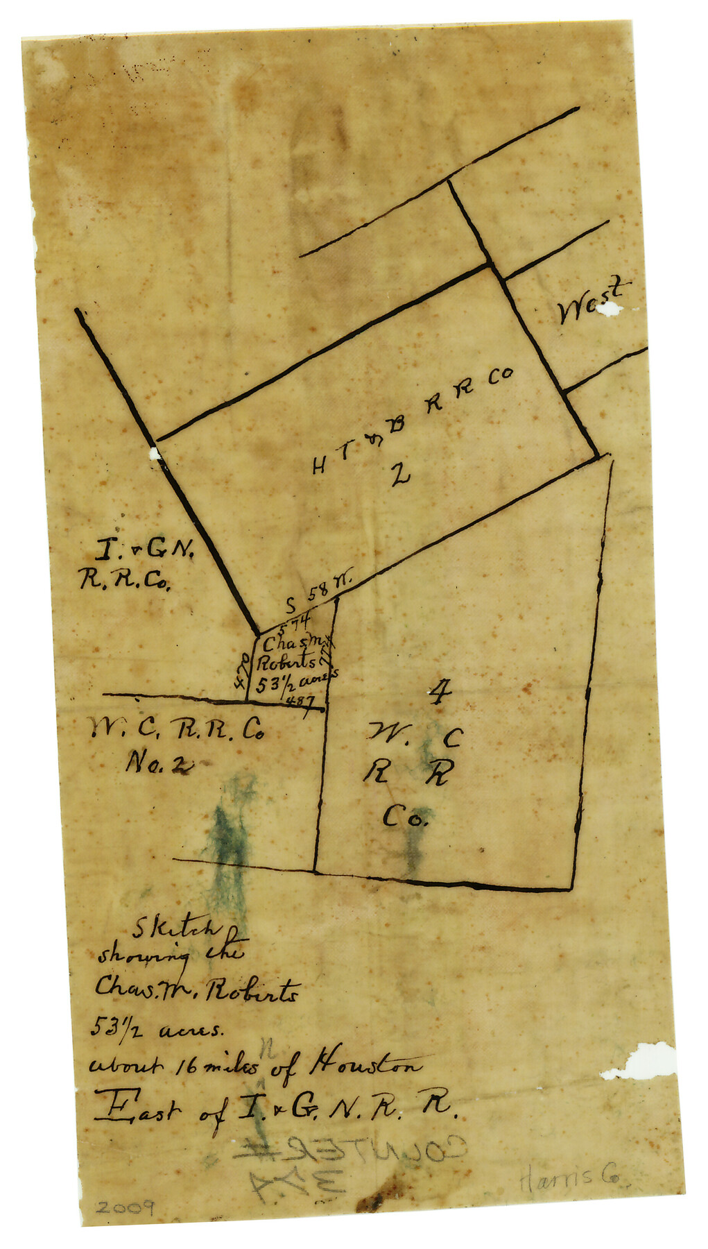
Sketch showing the Chas. M. Roberts 53 1/2 acres about 16 miles N of Houston, east of I.&G.N. R.R.
-
Map/Doc
374
-
Collection
Maddox Collection
-
Counties
Harris
-
Height x Width
8.0 x 5.9 inches
20.3 x 15.0 cm
-
Medium
paper, manuscript
Part of: Maddox Collection
Map of Calhoun County, Texas

Print $20.00
- Digital $50.00
Map of Calhoun County, Texas
1879
Size 22.8 x 18.7 inches
Map/Doc 670
Fannin County, Texas

Print $20.00
- Digital $50.00
Fannin County, Texas
1870
Size 22.7 x 18.8 inches
Map/Doc 725
Austin, Texas - Congress Ave. Drainage

Print $20.00
- Digital $50.00
Austin, Texas - Congress Ave. Drainage
1905
Size 15.8 x 31.2 inches
Map/Doc 458

Palo Pinto County, Texas

Print $20.00
- Digital $50.00
Palo Pinto County, Texas
1871
Size 28.8 x 23.4 inches
Map/Doc 660
Map of Fort Bend County, Texas

Print $20.00
- Digital $50.00
Map of Fort Bend County, Texas
1882
Size 23.0 x 25.7 inches
Map/Doc 434
Burnet County

Print $20.00
- Digital $50.00
Burnet County
1881
Size 16.0 x 16.2 inches
Map/Doc 75785
Map of surveys 189 & 190 T. C. R.R. Co. in Travis County, Texas

Print $20.00
- Digital $50.00
Map of surveys 189 & 190 T. C. R.R. Co. in Travis County, Texas
1915
Size 16.1 x 24.0 inches
Map/Doc 5079
Map showing the John B. Pier Survey, Near Houston

Print $3.00
- Digital $50.00
Map showing the John B. Pier Survey, Near Houston
Size 11.9 x 17.8 inches
Map/Doc 478
Map of the O-X Ranch in Cottle County, Texas

Print $20.00
- Digital $50.00
Map of the O-X Ranch in Cottle County, Texas
1916
Size 30.4 x 35.7 inches
Map/Doc 4439
Showing how the New County of Durant is bounded, from Official Maps from the General Land Office of Galveston, Harris, Fort Bend, and Brazoria Counties

Print $20.00
- Digital $50.00
Showing how the New County of Durant is bounded, from Official Maps from the General Land Office of Galveston, Harris, Fort Bend, and Brazoria Counties
1880
Size 18.6 x 19.0 inches
Map/Doc 4473
Part of Tom Green County, Texas (No. 3)

Print $20.00
- Digital $50.00
Part of Tom Green County, Texas (No. 3)
1870
Size 22.9 x 17.7 inches
Map/Doc 5047
You may also like
Karnes County Working Sketch 8

Print $40.00
- Digital $50.00
Karnes County Working Sketch 8
1962
Size 51.8 x 36.0 inches
Map/Doc 66656
Map of Darrington State Farm, Brazoria County, Texas

Print $20.00
- Digital $50.00
Map of Darrington State Farm, Brazoria County, Texas
Size 18.5 x 37.9 inches
Map/Doc 62985
Red River, Bois D'Arc Creek Floodway Sheet No. 2

Print $20.00
- Digital $50.00
Red River, Bois D'Arc Creek Floodway Sheet No. 2
1917
Size 20.4 x 29.9 inches
Map/Doc 69657
Aransas Pass to Baffin Bay

Print $20.00
- Digital $50.00
Aransas Pass to Baffin Bay
1922
Size 18.6 x 27.8 inches
Map/Doc 73409
Nueces County Sketch File 14

Print $20.00
- Digital $50.00
Nueces County Sketch File 14
Size 18.3 x 20.8 inches
Map/Doc 42179
Map of Tom Green County

Print $40.00
- Digital $50.00
Map of Tom Green County
1892
Size 42.9 x 48.2 inches
Map/Doc 63069
The Kennedy and Pringle Colony. June 3, 1842

Print $20.00
The Kennedy and Pringle Colony. June 3, 1842
2020
Size 23.0 x 17.7 inches
Map/Doc 96368
Orange County Sketch File 40

Print $20.00
- Digital $50.00
Orange County Sketch File 40
1895
Size 18.2 x 22.7 inches
Map/Doc 12128
Flight Mission No. BRA-8M, Frame 83, Jefferson County

Print $20.00
- Digital $50.00
Flight Mission No. BRA-8M, Frame 83, Jefferson County
1953
Size 15.8 x 15.7 inches
Map/Doc 85603
Brewster County Working Sketch 115

Print $40.00
- Digital $50.00
Brewster County Working Sketch 115
1985
Size 49.6 x 43.4 inches
Map/Doc 67715

Flight Mission No. DQN-1K, Frame 104, Calhoun County

Print $20.00
- Digital $50.00
Flight Mission No. DQN-1K, Frame 104, Calhoun County
1953
Size 18.4 x 22.1 inches
Map/Doc 84171