San Patricio County Sketch File 51
[Field notes locating the southeast corner of the Henry Smith labor lying on the north side of Copano Bay in Refugio County about 2 1/2 miles up the Bay from the Town of Bayside]
-
Map/Doc
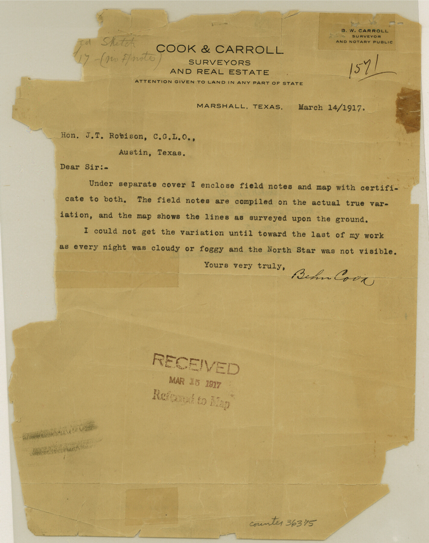
36375
-
Collection
General Map Collection
-
Object Dates
3/14/1917 (Creation Date)
3/15/1917 (File Date)
2/14-24/1917 (Survey Date)
-
People and Organizations
Behn Cook (Surveyor/Engineer)
Robert Hope (Chainman/Field Personnel)
G.M. Moore (Chainman/Field Personnel)
-
Counties
San Patricio Aransas Refugio
-
Subjects
Surveying Sketch File
-
Height x Width
11.2 x 8.8 inches
28.5 x 22.4 cm
-
Medium
paper, print
-
Comments
See San Patricio County Rolled Sketch 17 (7574) for sketch.
-
Features
Copano Bay
Bay Side
Mud Flat Ranch
Aransas River
Chiltipin Creek
Rincon Ranch
Related maps
San Patricio County Rolled Sketch 17

Print $20.00
- Digital $50.00
San Patricio County Rolled Sketch 17
1917
Size 18.1 x 28.1 inches
Map/Doc 7574
Part of: General Map Collection
Orange County NRC Article 33.136 Sketch 4

Print $24.00
- Digital $50.00
Orange County NRC Article 33.136 Sketch 4
2011
Size 22.6 x 31.2 inches
Map/Doc 93271
Denton County Sketch File 7

Print $8.00
- Digital $50.00
Denton County Sketch File 7
Size 13.7 x 7.9 inches
Map/Doc 20698
Current Miscellaneous File 107

Print $4.00
- Digital $50.00
Current Miscellaneous File 107
1994
Size 9.2 x 12.4 inches
Map/Doc 74707
Grimes County Working Sketch 9

Print $20.00
- Digital $50.00
Grimes County Working Sketch 9
1977
Size 20.1 x 30.3 inches
Map/Doc 63300
Uvalde County Working Sketch 55

Print $20.00
- Digital $50.00
Uvalde County Working Sketch 55
1983
Size 38.9 x 37.6 inches
Map/Doc 72125
Titus County Sketch File 11

Print $4.00
- Digital $50.00
Titus County Sketch File 11
1872
Size 8.2 x 10.1 inches
Map/Doc 38150

Nueces County Rolled Sketch 115

Print $215.00
Nueces County Rolled Sketch 115
1992
Size 24.2 x 35.2 inches
Map/Doc 7126
Hidalgo County Sketch File 18

Print $4.00
- Digital $50.00
Hidalgo County Sketch File 18
Size 12.0 x 8.1 inches
Map/Doc 26446
Flight Mission No. BRA-7M, Frame 133, Jefferson County

Print $20.00
- Digital $50.00
Flight Mission No. BRA-7M, Frame 133, Jefferson County
1953
Size 18.6 x 22.3 inches
Map/Doc 85527
Kinney County Working Sketch 18

Print $40.00
- Digital $50.00
Kinney County Working Sketch 18
1948
Size 56.7 x 40.5 inches
Map/Doc 70200
Flight Mission No. DQO-3K, Frame 34, Galveston County

Print $20.00
- Digital $50.00
Flight Mission No. DQO-3K, Frame 34, Galveston County
1952
Size 18.7 x 22.4 inches
Map/Doc 85075
You may also like
Flight Mission No. DAH-9M, Frame 158, Orange County

Print $20.00
- Digital $50.00
Flight Mission No. DAH-9M, Frame 158, Orange County
1953
Size 18.4 x 22.3 inches
Map/Doc 86857
Edwards County Working Sketch 93

Print $20.00
- Digital $50.00
Edwards County Working Sketch 93
1966
Size 30.7 x 35.7 inches
Map/Doc 68969
Harris County Sketch File 23a

Print $13.00
- Digital $50.00
Harris County Sketch File 23a
1839
Size 9.7 x 6.0 inches
Map/Doc 25379
Winkler Co., Tex., standard single county oil development survey

Print $20.00
- Digital $50.00
Winkler Co., Tex., standard single county oil development survey
Size 14.5 x 16.4 inches
Map/Doc 91972
McMullen County Rolled Sketch 3

Print $20.00
- Digital $50.00
McMullen County Rolled Sketch 3
1937
Size 16.2 x 37.2 inches
Map/Doc 6722
Armstrong County Sketch File A-2

Print $40.00
- Digital $50.00
Armstrong County Sketch File A-2
1918
Size 27.0 x 36.6 inches
Map/Doc 10843
Lubbock County Hale County

Print $20.00
- Digital $50.00
Lubbock County Hale County
Size 18.0 x 22.4 inches
Map/Doc 92833

[The S.K. Ry. of Texas, State Line to Pecos, Reeves Co., Texas]
![64164, [The S.K. Ry. of Texas, State Line to Pecos, Reeves Co., Texas], General Map Collection](https://historictexasmaps.com/wmedia_w700/maps/64164-1.tif.jpg)
Print $40.00
- Digital $50.00
[The S.K. Ry. of Texas, State Line to Pecos, Reeves Co., Texas]
1910
Size 18.7 x 95.8 inches
Map/Doc 64164
Flight Mission No. CRC-3R, Frame 17, Chambers County

Print $20.00
- Digital $50.00
Flight Mission No. CRC-3R, Frame 17, Chambers County
1956
Size 18.6 x 22.2 inches
Map/Doc 84791
[Warren Additions 3 and 4 and vicinity]
![92464, [Warren Additions 3 and 4 and vicinity], Twichell Survey Records](https://historictexasmaps.com/wmedia_w700/maps/92464-1.tif.jpg)
Print $20.00
- Digital $50.00
[Warren Additions 3 and 4 and vicinity]
Size 23.9 x 19.5 inches
Map/Doc 92464
Gregg County Working Sketch 9

Print $20.00
- Digital $50.00
Gregg County Working Sketch 9
1939
Size 20.3 x 34.8 inches
Map/Doc 63275