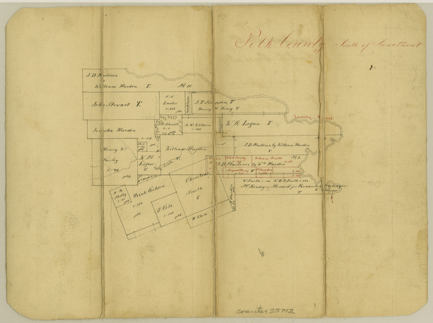
San Jacinto County Sketch File 9
[Office sketch of surveys on the west side of the Trinity River in the southeast corner of the county]
-
Map/Doc
35712
-
Collection
General Map Collection
-
Object Dates
12/18/1860 (Creation Date)
-
Counties
San Jacinto
-
Subjects
Surveying Sketch File
-
Height x Width
8.7 x 11.7 inches
22.1 x 29.7 cm
-
Medium
paper, manuscript
-
Features
Trinity River
Big Creek
Part of: General Map Collection
Lynn County Boundary File 6

Print $4.00
- Digital $50.00
Lynn County Boundary File 6
Size 10.9 x 8.8 inches
Map/Doc 56639
McMullen County Sketch File 41

Print $20.00
- Digital $50.00
McMullen County Sketch File 41
1939
Size 20.6 x 17.1 inches
Map/Doc 12065
Midland County Working Sketch 18

Print $40.00
- Digital $50.00
Midland County Working Sketch 18
1956
Size 26.5 x 49.5 inches
Map/Doc 70998
Flight Mission No. BRE-1P, Frame 94, Nueces County

Print $20.00
- Digital $50.00
Flight Mission No. BRE-1P, Frame 94, Nueces County
1956
Size 18.6 x 22.4 inches
Map/Doc 86665
Flight Mission No. CGI-4N, Frame 177, Cameron County

Print $20.00
- Digital $50.00
Flight Mission No. CGI-4N, Frame 177, Cameron County
1955
Size 18.5 x 22.2 inches
Map/Doc 84680
Brewster County Rolled Sketch 8

Print $40.00
- Digital $50.00
Brewster County Rolled Sketch 8
1878
Size 60.3 x 35.8 inches
Map/Doc 8467
[Right of Way & Track Map, The Texas & Pacific Ry. Co. Main Line]
![64678, [Right of Way & Track Map, The Texas & Pacific Ry. Co. Main Line], General Map Collection](https://historictexasmaps.com/wmedia_w700/maps/64678.tif.jpg)
Print $20.00
- Digital $50.00
[Right of Way & Track Map, The Texas & Pacific Ry. Co. Main Line]
Size 11.1 x 18.3 inches
Map/Doc 64678
Collingsworth County

Print $20.00
- Digital $50.00
Collingsworth County
1880
Size 24.9 x 20.0 inches
Map/Doc 3420
Gulf of Mexico

Print $20.00
- Digital $50.00
Gulf of Mexico
1905
Size 18.3 x 26.8 inches
Map/Doc 72653
Wilson County Sketch File 3b

Print $22.00
- Digital $50.00
Wilson County Sketch File 3b
Size 7.8 x 11.9 inches
Map/Doc 40402
Marion County Sketch File 17

Print $20.00
- Digital $50.00
Marion County Sketch File 17
Size 32.7 x 19.0 inches
Map/Doc 12026
Mexico & Guatimala with the Republic of Texas

Print $20.00
- Digital $50.00
Mexico & Guatimala with the Republic of Texas
1838
Size 19.3 x 22.6 inches
Map/Doc 94078
You may also like
Webb County Rolled Sketch 13

Print $20.00
- Digital $50.00
Webb County Rolled Sketch 13
Size 17.6 x 33.8 inches
Map/Doc 8177
Coleman County Sketch File 50

Print $4.00
- Digital $50.00
Coleman County Sketch File 50
Size 12.6 x 8.2 inches
Map/Doc 18853
Flight Mission No. BQY-4M, Frame 63, Harris County

Print $20.00
- Digital $50.00
Flight Mission No. BQY-4M, Frame 63, Harris County
1953
Size 18.7 x 22.4 inches
Map/Doc 85272

Ward County Working Sketch 42

Print $20.00
- Digital $50.00
Ward County Working Sketch 42
1970
Size 42.2 x 41.3 inches
Map/Doc 72348
Polk County Working Sketch 27

Print $40.00
- Digital $50.00
Polk County Working Sketch 27
1960
Size 45.9 x 51.2 inches
Map/Doc 71643
Portion of States Submerged Area in Matagorda Bay

Print $20.00
- Digital $50.00
Portion of States Submerged Area in Matagorda Bay
1922
Size 15.2 x 14.8 inches
Map/Doc 2953
Chambers County Sketch File 18b

Print $15.00
- Digital $50.00
Chambers County Sketch File 18b
1901
Size 9.2 x 8.1 inches
Map/Doc 17571
Wheeler County Sketch File 9

Print $12.00
- Digital $50.00
Wheeler County Sketch File 9
1989
Size 11.8 x 9.1 inches
Map/Doc 40008
Map of the Fort Worth and Denver City Railway, through Wilbarger County Texas, 1882

Print $40.00
- Digital $50.00
Map of the Fort Worth and Denver City Railway, through Wilbarger County Texas, 1882
Size 22.6 x 79.4 inches
Map/Doc 64427
Yoakum County Sketch File 1

Print $10.00
- Digital $50.00
Yoakum County Sketch File 1
Size 9.4 x 8.3 inches
Map/Doc 40697
Right of Way and Track Map, Dayton-Goose Creek Ry. Co., Station 401+20 to Station 612+40

Print $40.00
- Digital $50.00
Right of Way and Track Map, Dayton-Goose Creek Ry. Co., Station 401+20 to Station 612+40
1917
Size 25.4 x 56.4 inches
Map/Doc 64367