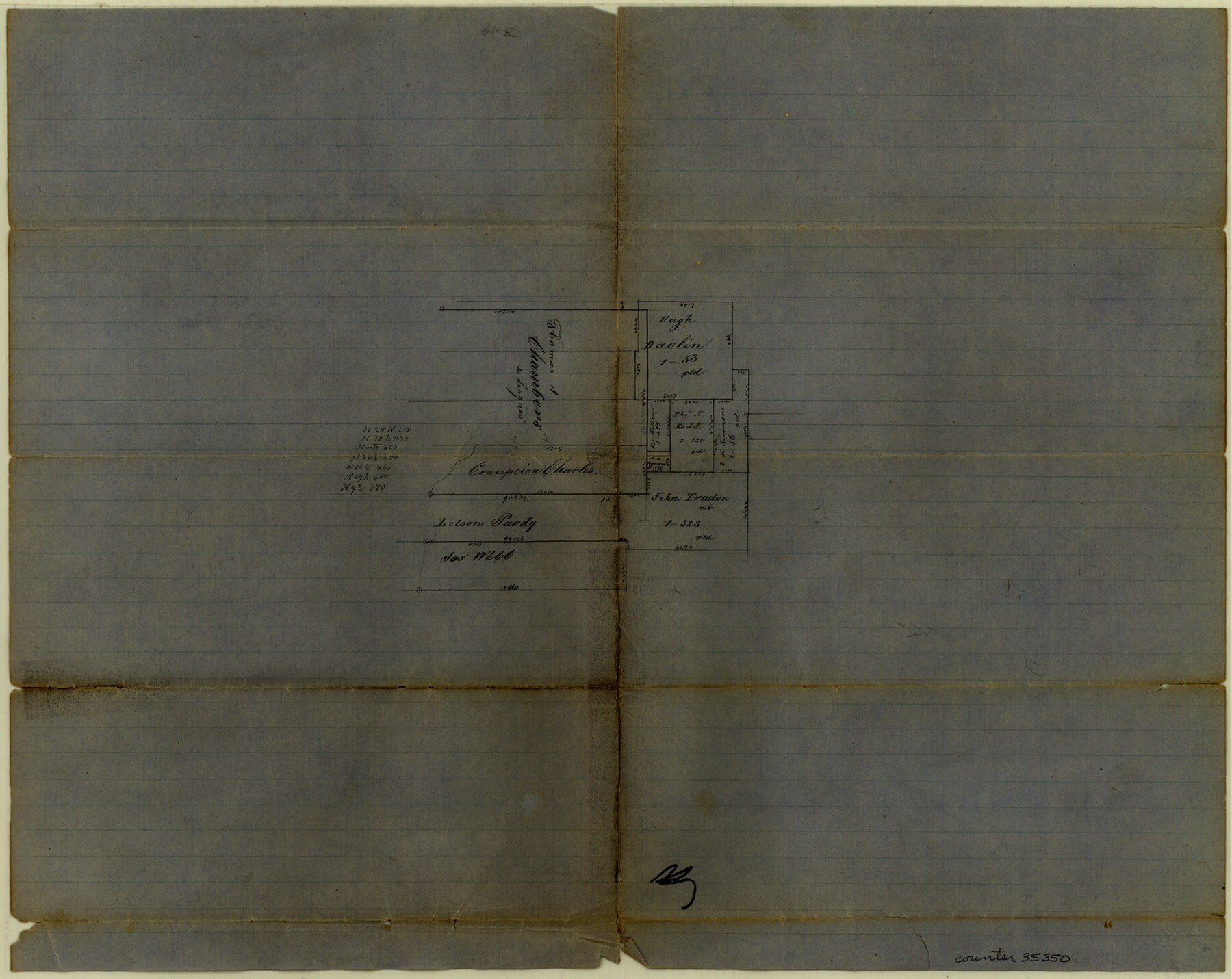
Robertson County Sketch File 3
[Office sketch of surveys in northwest corner of the county]
-
Map/Doc
35350
-
Collection
General Map Collection
-
Object Dates
1/19/1860 (Creation Date)
-
Counties
Robertson
-
Subjects
Surveying Sketch File
-
Height x Width
12.6 x 15.8 inches
32.0 x 40.1 cm
-
Medium
paper, manuscript
Part of: General Map Collection
Chambers County Rolled Sketch FD

Print $20.00
- Digital $50.00
Chambers County Rolled Sketch FD
1935
Size 32.7 x 26.5 inches
Map/Doc 5433
Pecos County Working Sketch 4

Print $40.00
- Digital $50.00
Pecos County Working Sketch 4
1929
Size 51.3 x 37.6 inches
Map/Doc 71474
Flight Mission No. BRE-2P, Frame 134, Nueces County

Print $20.00
- Digital $50.00
Flight Mission No. BRE-2P, Frame 134, Nueces County
1956
Size 18.4 x 22.3 inches
Map/Doc 86807
Cette Carte de Californie et du Nouveau Mexique est tiree de celle qui a ete envoyee par un grand d'Espagne pour etre communiquee a Mrs. de l'Academie Royale des Sciences

Print $20.00
- Digital $50.00
Cette Carte de Californie et du Nouveau Mexique est tiree de celle qui a ete envoyee par un grand d'Espagne pour etre communiquee a Mrs. de l'Academie Royale des Sciences
Size 11.8 x 16.5 inches
Map/Doc 95924

Matagorda County Working Sketch 11

Print $20.00
- Digital $50.00
Matagorda County Working Sketch 11
1957
Size 34.6 x 43.6 inches
Map/Doc 70869
Calhoun County Sketch File 3

Print $4.00
- Digital $50.00
Calhoun County Sketch File 3
Size 8.0 x 12.0 inches
Map/Doc 35899
Dimmit County Sketch File 13

Print $46.00
- Digital $50.00
Dimmit County Sketch File 13
1884
Size 22.6 x 36.5 inches
Map/Doc 11341
Lampasas County Working Sketch 20, revised

Print $20.00
- Digital $50.00
Lampasas County Working Sketch 20, revised
1981
Size 27.1 x 34.5 inches
Map/Doc 70298
Milam County Sketch File 8

Print $20.00
- Digital $50.00
Milam County Sketch File 8
1856
Size 16.8 x 33.7 inches
Map/Doc 12091
Jeff Davis County Sketch File 45

Print $10.00
- Digital $50.00
Jeff Davis County Sketch File 45
1890
Size 14.0 x 8.5 inches
Map/Doc 28075
Outer Continental Shelf Leasing Maps (Louisiana Offshore Operations)

Print $20.00
- Digital $50.00
Outer Continental Shelf Leasing Maps (Louisiana Offshore Operations)
1959
Size 17.8 x 14.1 inches
Map/Doc 76095
You may also like
Reagan County Boundary File 1a

Print $50.00
- Digital $50.00
Reagan County Boundary File 1a
Size 14.4 x 8.7 inches
Map/Doc 58154
Duval County Working Sketch 21

Print $20.00
- Digital $50.00
Duval County Working Sketch 21
1941
Size 16.9 x 11.8 inches
Map/Doc 68745
Newton County Working Sketch 13

Print $20.00
- Digital $50.00
Newton County Working Sketch 13
1946
Size 34.4 x 34.2 inches
Map/Doc 71259
San Augustine County Working Sketch 5

Print $20.00
- Digital $50.00
San Augustine County Working Sketch 5
1935
Size 39.0 x 37.4 inches
Map/Doc 63692
PSL Field Notes for Blocks C13 and C14 in Jeff Davis and Reeves Counties, Block C17 in Culberson and Reeves Counties, and Blocks C11, C12, C15, C16, C18, C19, C20, and C21 in Reeves County

PSL Field Notes for Blocks C13 and C14 in Jeff Davis and Reeves Counties, Block C17 in Culberson and Reeves Counties, and Blocks C11, C12, C15, C16, C18, C19, C20, and C21 in Reeves County
Map/Doc 81672
Hardin County Rolled Sketch 8

Print $20.00
- Digital $50.00
Hardin County Rolled Sketch 8
1947
Size 23.7 x 25.8 inches
Map/Doc 6081
Houston County Sketch File 18

Print $4.00
- Digital $50.00
Houston County Sketch File 18
Size 4.8 x 10.3 inches
Map/Doc 26781
Flight Mission No. CLL-4N, Frame 37, Willacy County

Print $20.00
- Digital $50.00
Flight Mission No. CLL-4N, Frame 37, Willacy County
1954
Size 18.4 x 22.1 inches
Map/Doc 87110
Travis County Rolled Sketch 54

Print $20.00
- Digital $50.00
Travis County Rolled Sketch 54
Size 25.2 x 36.7 inches
Map/Doc 8046
[Beaumont, Sour Lake and Western Ry. Right of Way and Alignment - Frisco]
![64110, [Beaumont, Sour Lake and Western Ry. Right of Way and Alignment - Frisco], General Map Collection](https://historictexasmaps.com/wmedia_w700/maps/64110.tif.jpg)
Print $20.00
- Digital $50.00
[Beaumont, Sour Lake and Western Ry. Right of Way and Alignment - Frisco]
1910
Size 20.2 x 46.3 inches
Map/Doc 64110
Hudspeth County Working Sketch 41

Print $20.00
- Digital $50.00
Hudspeth County Working Sketch 41
1981
Size 18.3 x 37.1 inches
Map/Doc 66326
[Aransas and Corpus Christi Bays]
![140, [Aransas and Corpus Christi Bays], General Map Collection](https://historictexasmaps.com/wmedia_w700/maps/140.tif.jpg)
Print $3.00
- Digital $50.00
[Aransas and Corpus Christi Bays]
1839
Size 11.4 x 16.5 inches
Map/Doc 140