Nueces County Sketch File 64
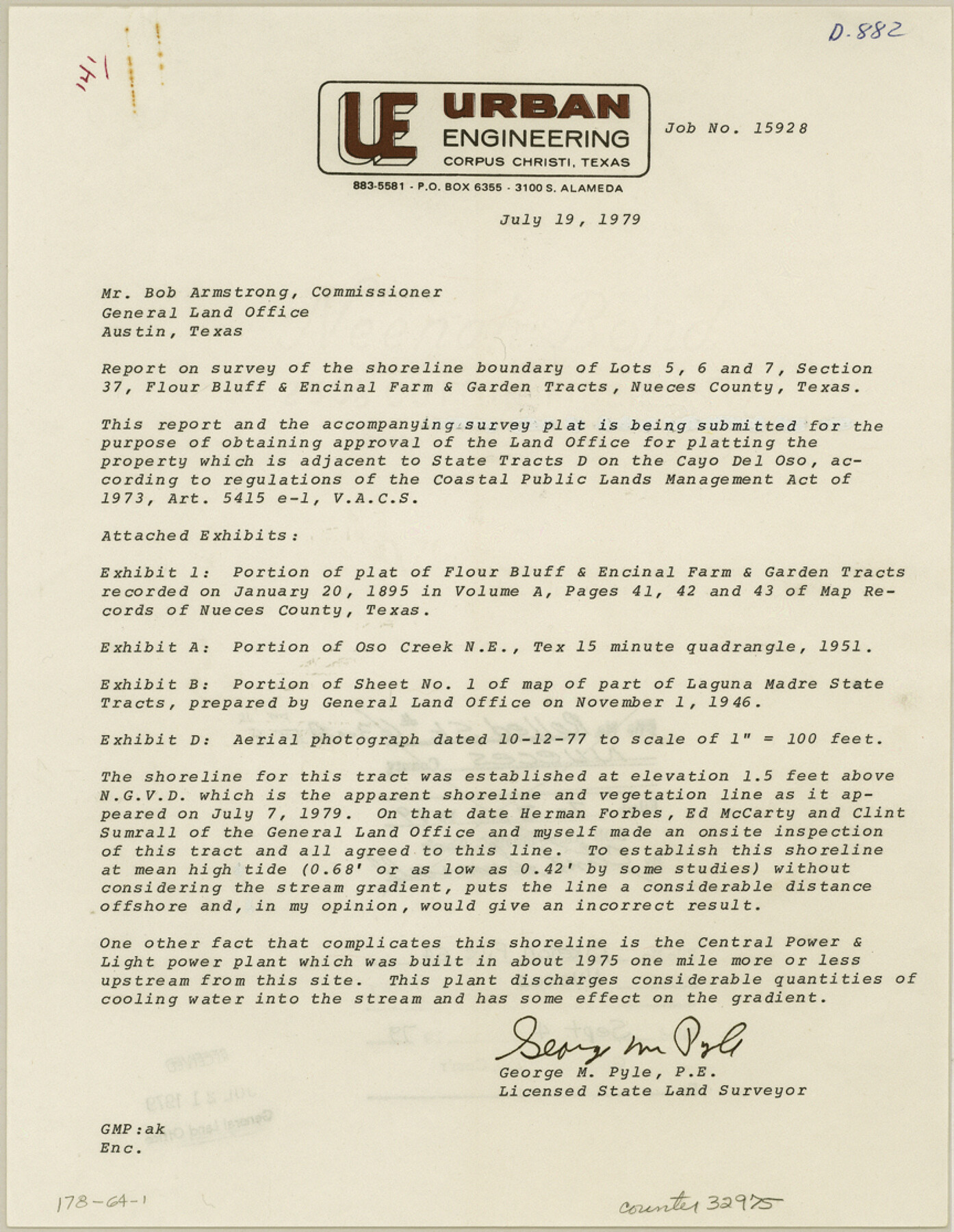
[Report on survey of the shoreline boundary of Lots 5, 6 and 7, section 37, Flour Bluff and Encinal Farm and Garden Tracts]
-
Map/Doc
32975
-
Collection
General Map Collection
-
Object Dates
6/1/1979 (Creation Date)
7/31/1979 (File Date)
7/19/1979 (Correspondence Date)
11/1/1946 (Creation Date)
1948 (Creation Date)
-
People and Organizations
George M. Pyle (Surveyor/Engineer)
-
Counties
Nueces
-
Subjects
Surveying Sketch File
-
Height x Width
11.2 x 8.6 inches
28.5 x 21.8 cm
-
Medium
multi-page, multi-format
-
Comments
See Nueces County Rolled Sketch 63 (6909) for sketch.
-
Features
Flour Bluff
Encinal Farm
Cayo del Oso
Oso Creek
Peary Place
Laguna Madre
San Patricio Causeway Lighthouse
Mud Bridge
Related maps
Nueces County Rolled Sketch 63

Print $20.00
- Digital $50.00
Nueces County Rolled Sketch 63
1979
Size 25.5 x 38.1 inches
Map/Doc 6909
Part of: General Map Collection
Mitchell County Boundary File 66

Print $13.00
- Digital $50.00
Mitchell County Boundary File 66
Size 7.9 x 3.7 inches
Map/Doc 57372
[Jack District]
![1992, [Jack District], General Map Collection](https://historictexasmaps.com/wmedia_w700/maps/1992.tif.jpg)
Print $40.00
- Digital $50.00
[Jack District]
1880
Size 52.7 x 43.4 inches
Map/Doc 1992
[Sketch for Mineral Application 26501 - Sabine River, T. A. Oldhausen]
![2847, [Sketch for Mineral Application 26501 - Sabine River, T. A. Oldhausen], General Map Collection](https://historictexasmaps.com/wmedia_w700/maps/2847.tif.jpg)
Print $20.00
- Digital $50.00
[Sketch for Mineral Application 26501 - Sabine River, T. A. Oldhausen]
1931
Size 24.7 x 37.1 inches
Map/Doc 2847
Chambers County Rolled Sketch 30

Print $20.00
- Digital $50.00
Chambers County Rolled Sketch 30
1952
Size 26.7 x 37.9 inches
Map/Doc 5430
Flight Mission No. BQR-16K, Frame 31, Brazoria County

Print $20.00
- Digital $50.00
Flight Mission No. BQR-16K, Frame 31, Brazoria County
1952
Size 18.5 x 22.1 inches
Map/Doc 84098
Montgomery County Rolled Sketch 40A

Print $40.00
- Digital $50.00
Montgomery County Rolled Sketch 40A
1970
Size 40.4 x 57.5 inches
Map/Doc 9547
Oldham County Working Sketch 4

Print $20.00
- Digital $50.00
Oldham County Working Sketch 4
1948
Size 28.8 x 26.2 inches
Map/Doc 71326
Johnson County Working Sketch 2

Print $20.00
- Digital $50.00
Johnson County Working Sketch 2
Size 20.8 x 20.2 inches
Map/Doc 66615
Motley County

Print $20.00
- Digital $50.00
Motley County
1914
Size 47.0 x 37.7 inches
Map/Doc 66946
[Surveys in the Montgomery District: San Jacinto River and Caney Creek, Navidad, Navasota]
![69744, [Surveys in the Montgomery District: San Jacinto River and Caney Creek, Navidad, Navasota], General Map Collection](https://historictexasmaps.com/wmedia_w700/maps/69744.tif.jpg)
Print $2.00
- Digital $50.00
[Surveys in the Montgomery District: San Jacinto River and Caney Creek, Navidad, Navasota]
Size 5.1 x 7.3 inches
Map/Doc 69744
Cherokee County Sketch File 13

Print $6.00
- Digital $50.00
Cherokee County Sketch File 13
1859
Size 14.8 x 9.4 inches
Map/Doc 18145
Crosby County Sketch File 25

Print $12.00
- Digital $50.00
Crosby County Sketch File 25
1912
Size 11.2 x 8.7 inches
Map/Doc 20093
You may also like
[Block B&, and Adjacent Leagues]
![91432, [Block B&, and Adjacent Leagues], Twichell Survey Records](https://historictexasmaps.com/wmedia_w700/maps/91432-1.tif.jpg)
Print $20.00
- Digital $50.00
[Block B&, and Adjacent Leagues]
Size 30.7 x 29.6 inches
Map/Doc 91432
Kent County Working Sketch 18

Print $20.00
- Digital $50.00
Kent County Working Sketch 18
1974
Size 33.5 x 31.5 inches
Map/Doc 70025
Baie de Galvez-Town

Print $20.00
- Digital $50.00
Baie de Galvez-Town
1820
Size 10.3 x 12.9 inches
Map/Doc 95832
Loving County Rolled Sketch 19

Print $20.00
- Digital $50.00
Loving County Rolled Sketch 19
2020
Size 24.4 x 35.3 inches
Map/Doc 96575
Culberson County Sketch File 22

Print $6.00
- Digital $50.00
Culberson County Sketch File 22
1934
Size 11.8 x 8.8 inches
Map/Doc 20234
Laguna Madre, Register No. 1477B

Print $40.00
- Digital $50.00
Laguna Madre, Register No. 1477B
1880
Size 33.4 x 56.6 inches
Map/Doc 73607
Hays County Working Sketch 21

Print $40.00
- Digital $50.00
Hays County Working Sketch 21
1980
Size 42.7 x 65.6 inches
Map/Doc 66095
The Official Map of the City of El Paso, State of Texas

Print $20.00
The Official Map of the City of El Paso, State of Texas
1889
Size 42.2 x 50.5 inches
Map/Doc 89615
Willacy County Boundary File 2

Print $16.00
- Digital $50.00
Willacy County Boundary File 2
Size 11.0 x 8.7 inches
Map/Doc 59967
Erath County Sketch File 13a

Print $6.00
- Digital $50.00
Erath County Sketch File 13a
1872
Size 10.3 x 8.2 inches
Map/Doc 22287

Lynn County Sketch File 1

Print $8.00
- Digital $50.00
Lynn County Sketch File 1
1892
Size 14.0 x 8.8 inches
Map/Doc 30443