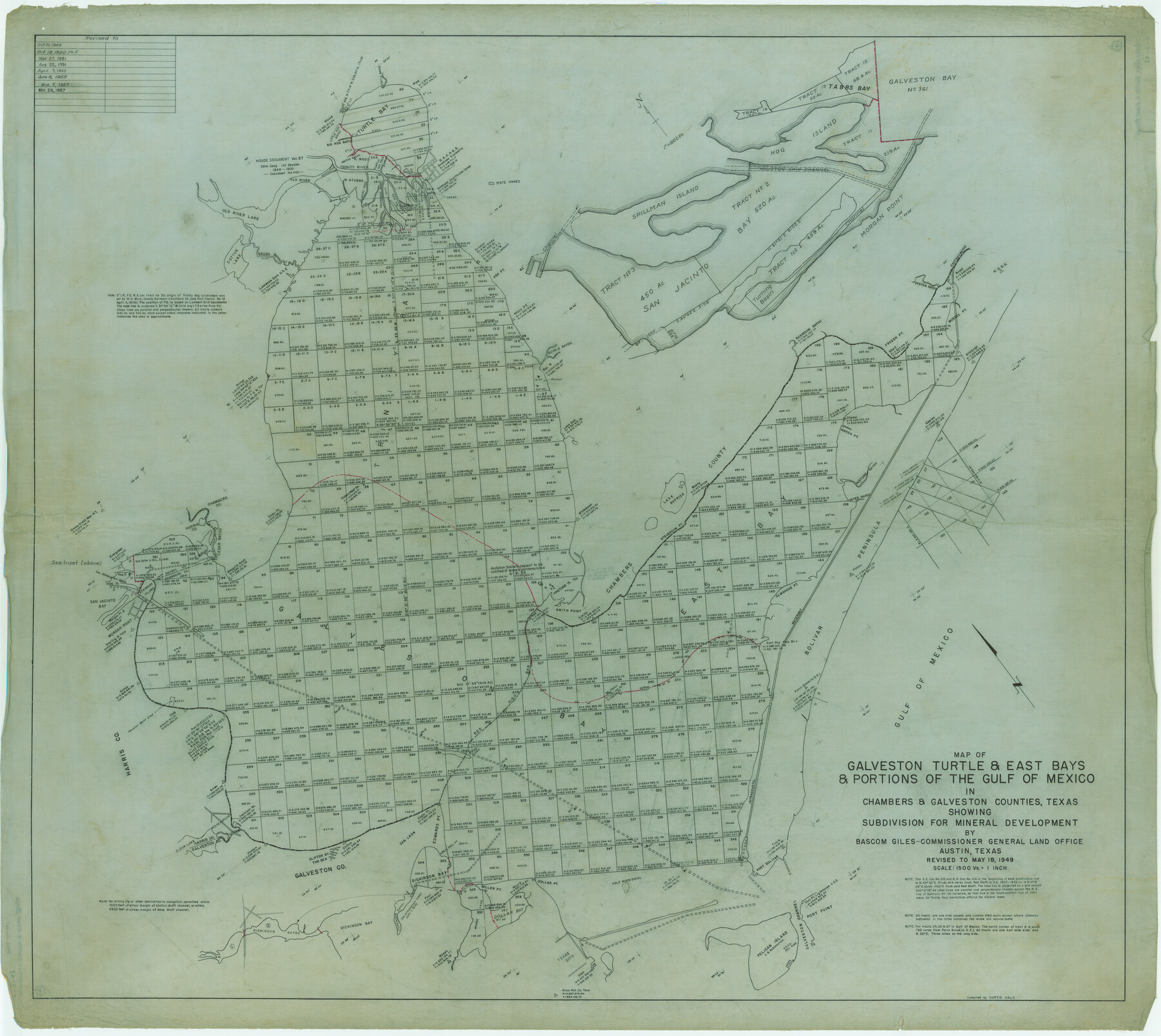
Map of Galveston, Turtle & East Bays & portions of the Gulf of Mexico in Chambers & Galveston Counties, Texas showing subdivision for mineral development
K-3-43
-
Map/Doc
2977
-
Collection
General Map Collection
-
Object Dates
1949 (Creation Date)
-
People and Organizations
General Land Office (Publisher)
-
Counties
Chambers Galveston
-
Subjects
Energy Offshore Submerged Area
-
Height x Width
48.9 x 54.8 inches
124.2 x 139.2 cm
Part of: General Map Collection

Flight Mission No. CRE-2R, Frame 158, Jackson County

Print $20.00
- Digital $50.00
Flight Mission No. CRE-2R, Frame 158, Jackson County
1956
Size 16.1 x 16.1 inches
Map/Doc 85369
Kendall County Working Sketch 24

Print $20.00
- Digital $50.00
Kendall County Working Sketch 24
1977
Size 27.6 x 26.1 inches
Map/Doc 66696
La Salle County Sketch File 32

Print $16.00
- Digital $50.00
La Salle County Sketch File 32
1883
Size 14.3 x 8.8 inches
Map/Doc 29576
Flight Mission No. BRA-6M, Frame 144, Jefferson County

Print $20.00
- Digital $50.00
Flight Mission No. BRA-6M, Frame 144, Jefferson County
1953
Size 18.5 x 22.3 inches
Map/Doc 85445
Webb County Rolled Sketch 12

Print $20.00
- Digital $50.00
Webb County Rolled Sketch 12
Size 17.6 x 18.5 inches
Map/Doc 8176
Orange County Working Sketch 16

Print $20.00
- Digital $50.00
Orange County Working Sketch 16
1929
Size 25.0 x 24.2 inches
Map/Doc 71348
Hamilton County Sketch File 7

Print $40.00
- Digital $50.00
Hamilton County Sketch File 7
1860
Size 12.2 x 15.3 inches
Map/Doc 24912
Hardeman County Sketch File 11

Print $42.00
- Digital $50.00
Hardeman County Sketch File 11
Size 9.2 x 9.1 inches
Map/Doc 25008
Taylor County Working Sketch 16

Print $20.00
- Digital $50.00
Taylor County Working Sketch 16
1981
Size 28.8 x 41.2 inches
Map/Doc 69626

Edwards County Sketch File 21

Print $6.00
- Digital $50.00
Edwards County Sketch File 21
1889
Size 12.9 x 8.5 inches
Map/Doc 21740
You may also like

Flight Mission No. BRA-16M, Frame 102, Jefferson County

Print $20.00
- Digital $50.00
Flight Mission No. BRA-16M, Frame 102, Jefferson County
1953
Size 18.6 x 22.3 inches
Map/Doc 85714
[Bastrop District]
![83006, [Bastrop District], General Map Collection](https://historictexasmaps.com/wmedia_w700/maps/83006-1.tif.jpg)
Print $40.00
- Digital $50.00
[Bastrop District]
1895
Size 71.8 x 52.3 inches
Map/Doc 83006
Leon County Working Sketch 31

Print $20.00
- Digital $50.00
Leon County Working Sketch 31
1974
Size 24.4 x 18.6 inches
Map/Doc 70430
Montgomery County Rolled Sketch 27

Print $20.00
- Digital $50.00
Montgomery County Rolled Sketch 27
Size 34.5 x 34.4 inches
Map/Doc 9536
Wise County Sketch File 49

Print $20.00
- Digital $50.00
Wise County Sketch File 49
1882
Size 15.5 x 20.8 inches
Map/Doc 12702
Wichita County Sketch File 26

Print $20.00
- Digital $50.00
Wichita County Sketch File 26
1919
Size 24.9 x 36.6 inches
Map/Doc 12686
Map of Kyle, Lockhart & Southern Ry.

Print $40.00
- Digital $50.00
Map of Kyle, Lockhart & Southern Ry.
1882
Size 14.5 x 94.9 inches
Map/Doc 64285
Cameron County

Print $20.00
- Digital $50.00
Cameron County
1976
Size 31.0 x 38.3 inches
Map/Doc 95447
[Surveys in the Milam District along the Brazos River, North Bosque River, West Bosque River and Cow Bayou]
![231, [Surveys in the Milam District along the Brazos River, North Bosque River, West Bosque River and Cow Bayou], General Map Collection](https://historictexasmaps.com/wmedia_w700/maps/231.tif.jpg)
Print $2.00
- Digital $50.00
[Surveys in the Milam District along the Brazos River, North Bosque River, West Bosque River and Cow Bayou]
1846
Size 11.7 x 8.9 inches
Map/Doc 231
Wheeler County Working Sketch 18

Print $20.00
- Digital $50.00
Wheeler County Working Sketch 18
1985
Size 38.0 x 41.8 inches
Map/Doc 72507
Map of Shackelford County

Print $20.00
- Digital $50.00
Map of Shackelford County
1895
Size 24.1 x 19.5 inches
Map/Doc 4026