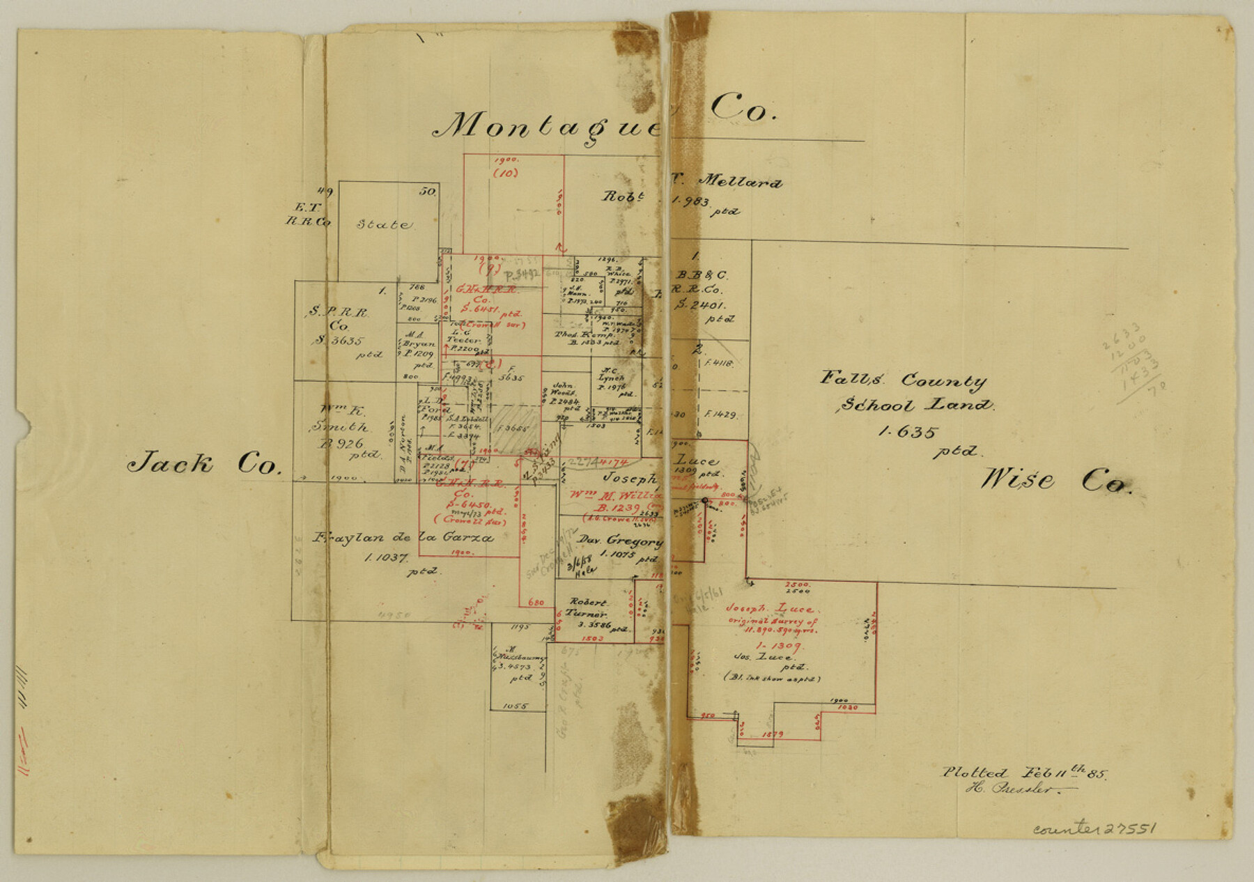
Jack County Sketch File 16a
[Sketch in northeast part of county]
-
Map/Doc
27551
-
Collection
General Map Collection
-
Object Dates
2/11/1885 (Creation Date)
2/11/1885 (File Date)
-
People and Organizations
H. Pressler (Draftsman)
-
Counties
Jack Wise Montague
-
Subjects
Surveying Sketch File
-
Height x Width
8.3 x 11.8 inches
21.1 x 30.0 cm
-
Medium
paper, manuscript
Part of: General Map Collection

Potter County Sketch File 19

Print $20.00
- Digital $50.00
Potter County Sketch File 19
Size 23.7 x 15.5 inches
Map/Doc 12202
Industrial - Commercial - Progressive Dallas

Industrial - Commercial - Progressive Dallas
1940
Size 19.1 x 23.7 inches
Map/Doc 96509
Webb County Working Sketch 97

Print $20.00
- Digital $50.00
Webb County Working Sketch 97
1994
Size 27.1 x 30.6 inches
Map/Doc 72464
Fort Bend County State Real Property Sketch 18

Print $40.00
- Digital $50.00
Fort Bend County State Real Property Sketch 18
2006
Size 17.7 x 24.0 inches
Map/Doc 88615
Sabine County Working Sketch 13

Print $20.00
- Digital $50.00
Sabine County Working Sketch 13
1935
Size 35.3 x 44.2 inches
Map/Doc 63684
Galveston County Rolled Sketch 44

Print $20.00
- Digital $50.00
Galveston County Rolled Sketch 44
1992
Size 30.6 x 23.7 inches
Map/Doc 5977
Pecos County Working Sketch 107

Print $40.00
- Digital $50.00
Pecos County Working Sketch 107
1971
Size 55.3 x 37.4 inches
Map/Doc 71580
Refugio County Sketch File 1

Print $8.00
- Digital $50.00
Refugio County Sketch File 1
1846
Size 12.6 x 7.8 inches
Map/Doc 35235

Shackelford County Working Sketch Graphic Index

Print $20.00
- Digital $50.00
Shackelford County Working Sketch Graphic Index
1972
Size 42.2 x 36.1 inches
Map/Doc 76696
Flight Mission No. BRA-6M, Frame 93, Jefferson County

Print $20.00
- Digital $50.00
Flight Mission No. BRA-6M, Frame 93, Jefferson County
1953
Size 18.7 x 22.4 inches
Map/Doc 85436
You may also like
San Jacinto County Working Sketch 42b

Print $3.00
- Digital $50.00
San Jacinto County Working Sketch 42b
1979
Size 10.7 x 14.4 inches
Map/Doc 63756
Texas, the Empire State of the Southwest

Texas, the Empire State of the Southwest
1909
Size 9.7 x 5.4 inches
Map/Doc 96603
Railroad Track Map, H&TCRRCo., Falls County, Texas

Print $4.00
- Digital $50.00
Railroad Track Map, H&TCRRCo., Falls County, Texas
1918
Size 11.7 x 18.4 inches
Map/Doc 62862
Matagorda County Sketch File 30

Print $20.00
- Digital $50.00
Matagorda County Sketch File 30
1911
Size 22.2 x 31.9 inches
Map/Doc 12045
Travis County Working Sketch 9

Print $20.00
- Digital $50.00
Travis County Working Sketch 9
1918
Size 21.9 x 28.9 inches
Map/Doc 69393
Flight Mission No. DIX-3P, Frame 136, Aransas County

Print $20.00
- Digital $50.00
Flight Mission No. DIX-3P, Frame 136, Aransas County
1956
Size 17.9 x 19.0 inches
Map/Doc 83766
Wichita County

Print $20.00
- Digital $50.00
Wichita County
1971
Size 35.8 x 37.7 inches
Map/Doc 77457
Duval County Working Sketch 26

Print $20.00
- Digital $50.00
Duval County Working Sketch 26
1947
Size 34.8 x 36.9 inches
Map/Doc 68750
Roberts County Working Sketch 41

Print $20.00
- Digital $50.00
Roberts County Working Sketch 41
1978
Size 26.6 x 22.6 inches
Map/Doc 63567
Concho County Sketch File 35

Print $20.00
- Digital $50.00
Concho County Sketch File 35
1937
Size 14.9 x 15.5 inches
Map/Doc 11160
General Highway Map, Floyd County, Texas

Print $20.00
- Digital $50.00
General Highway Map, Floyd County, Texas
1950
Size 18.8 x 25.7 inches
Map/Doc 92973
Hunt County Working Sketch 5

Print $20.00
- Digital $50.00
Hunt County Working Sketch 5
1942
Size 23.8 x 20.2 inches
Map/Doc 66352