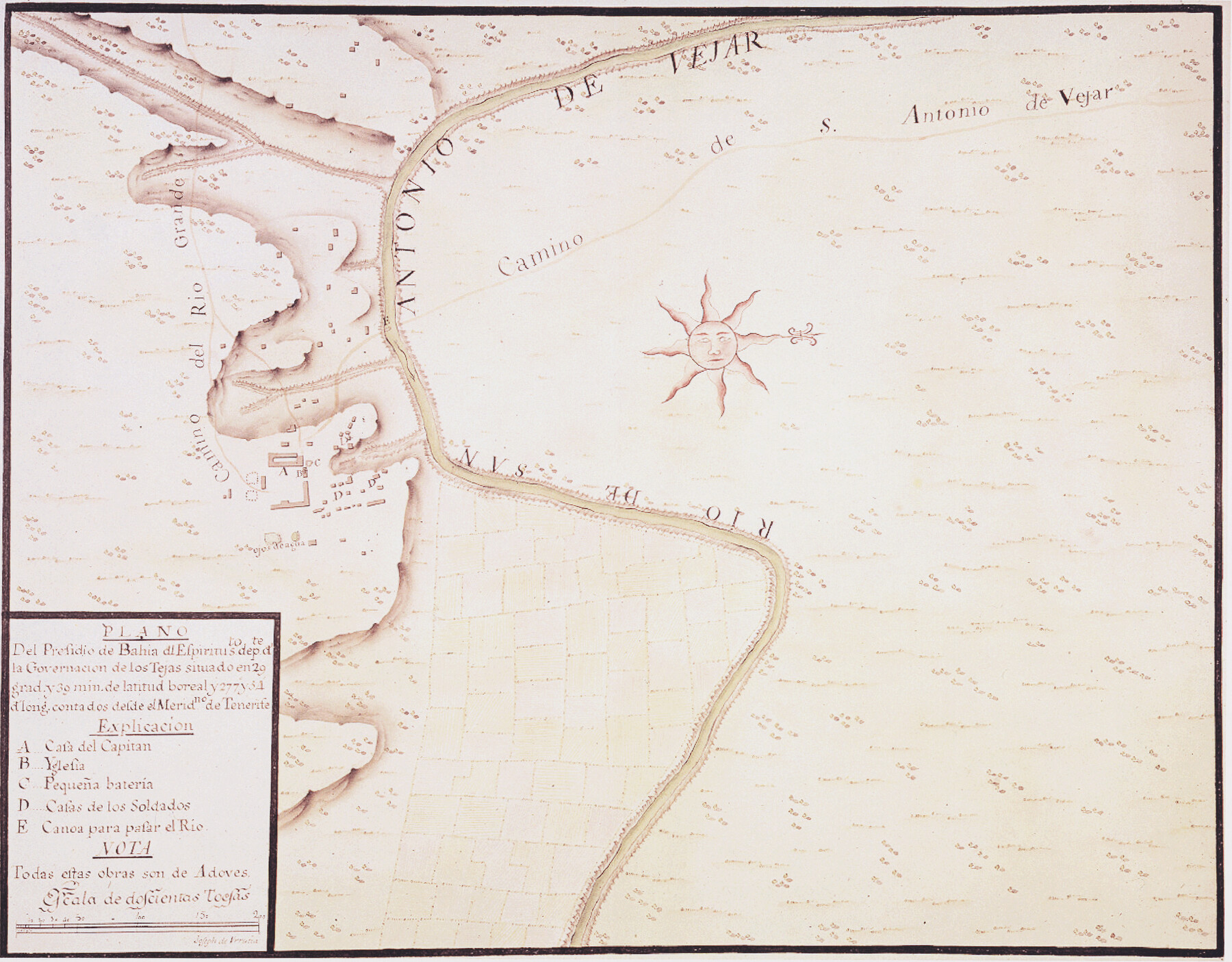
Plano del Presidio de Bahia dl Espiritus to dep te d' la Governacion de los Tejas
-
Map/Doc
96516
-
Collection
Non-GLO Digital Images
-
Object Dates
[1766] (Creation Date)
-
Subjects
Spanish Texas
-
Height x Width
10.2 x 13.0 inches
25.9 x 33.0 cm
-
Medium
digital image
-
Comments
For research purposes only.
Image citation: Texas Map Collection, e_txmp_0321, the Dolph Briscoe Center for American History, the University of Texas at Austin
Part of: Non-GLO Digital Images
Engineer map showing engineer information at 23 O'Clock 23 Oct. 1918 drawn under direction of Col. W.A. Mitchell - Verso

Print $20.00
Engineer map showing engineer information at 23 O'Clock 23 Oct. 1918 drawn under direction of Col. W.A. Mitchell - Verso
1918
Size 19.7 x 12.6 inches
Map/Doc 94128
Map of the City of Austin

Print $20.00
Map of the City of Austin
1910
Size 24.0 x 18.0 inches
Map/Doc 90071
Map of South Eastern Washington Territory

Print $20.00
Map of South Eastern Washington Territory
1878
Size 31.3 x 41.1 inches
Map/Doc 93942

[Movements & Objectives of the 143rd & 144th Infantry on October 9-11, 1918, Appendix E, Nos.2 and 3]
![94131, [Movements & Objectives of the 143rd & 144th Infantry on October 9-11, 1918, Appendix E, Nos.2 and 3], Non-GLO Digital Images](https://historictexasmaps.com/wmedia_w700/maps/94131-1.tif.jpg)
Print $20.00
[Movements & Objectives of the 143rd & 144th Infantry on October 9-11, 1918, Appendix E, Nos.2 and 3]
1918
Size 41.6 x 19.9 inches
Map/Doc 94131
[Movements & Objectives of the 143rd & 144th Infantry and many other divisions and regiments, 1918] - Verso
![94139, [Movements & Objectives of the 143rd & 144th Infantry and many other divisions and regiments, 1918] - Verso, Non-GLO Digital Images](https://historictexasmaps.com/wmedia_w700/maps/94139-1.tif.jpg)
Print $40.00
[Movements & Objectives of the 143rd & 144th Infantry and many other divisions and regiments, 1918] - Verso
1918
Size 37.2 x 63.9 inches
Map/Doc 94139
The Scarborough Company's New Railroad, Post Office & County Map of Texas, Oklahoma and Indian Territory Compiled from the Latest Government Surveys and Original Sources

Print $20.00
The Scarborough Company's New Railroad, Post Office & County Map of Texas, Oklahoma and Indian Territory Compiled from the Latest Government Surveys and Original Sources
1904
Size 43.1 x 47.8 inches
Map/Doc 93967
Preliminary Survey of the Entrance to the Rio Grande, Texas

Print $20.00
Preliminary Survey of the Entrance to the Rio Grande, Texas
1854
Size 14.2 x 14.9 inches
Map/Doc 95283
Bird's Eye View of the City of Waco

Print $20.00
Bird's Eye View of the City of Waco
1873
Size 19.6 x 24.0 inches
Map/Doc 89211

Bird's Eye View of the City of Brenham, Washington County, Texas

Print $20.00
Bird's Eye View of the City of Brenham, Washington County, Texas
1881
Size 19.4 x 26.7 inches
Map/Doc 89076
Oldham County Surveyor's Oath of Office

Print $3.00
Oldham County Surveyor's Oath of Office
1881
Size 15.2 x 9.7 inches
Map/Doc 47716
You may also like
Bosque County Working Sketch 21

Print $40.00
- Digital $50.00
Bosque County Working Sketch 21
1984
Size 38.5 x 55.1 inches
Map/Doc 67454
Flight Mission No. DQN-6K, Frame 17, Calhoun County

Print $20.00
- Digital $50.00
Flight Mission No. DQN-6K, Frame 17, Calhoun County
1953
Size 18.5 x 22.1 inches
Map/Doc 84439
[T. A. Thomson Block T, R. M. Thomson Block 1]
![90968, [T. A. Thomson Block T, R. M. Thomson Block 1], Twichell Survey Records](https://historictexasmaps.com/wmedia_w700/maps/90968-1.tif.jpg)
Print $20.00
- Digital $50.00
[T. A. Thomson Block T, R. M. Thomson Block 1]
Size 12.3 x 17.5 inches
Map/Doc 90968
Crockett County Rolled Sketch 76

Print $20.00
- Digital $50.00
Crockett County Rolled Sketch 76
1950
Size 24.6 x 26.1 inches
Map/Doc 5617
Map of Jasper County

Print $40.00
- Digital $50.00
Map of Jasper County
1898
Size 49.1 x 39.6 inches
Map/Doc 66879
Eastland County Sketch File 7

Print $4.00
- Digital $50.00
Eastland County Sketch File 7
1872
Size 12.6 x 8.5 inches
Map/Doc 21574
Map of Collin County

Print $20.00
- Digital $50.00
Map of Collin County
1862
Size 24.4 x 20.5 inches
Map/Doc 1084
Hardin County Rolled Sketch 13

Print $20.00
- Digital $50.00
Hardin County Rolled Sketch 13
Size 36.0 x 42.3 inches
Map/Doc 9187
Tom Green County Rolled Sketch 17

Print $40.00
- Digital $50.00
Tom Green County Rolled Sketch 17
Size 49.2 x 37.8 inches
Map/Doc 10005
Brewster County Working Sketch 7

Print $20.00
- Digital $50.00
Brewster County Working Sketch 7
1909
Size 39.9 x 17.1 inches
Map/Doc 67540
Flight Mission No. DQO-8K, Frame 78, Galveston County

Print $20.00
- Digital $50.00
Flight Mission No. DQO-8K, Frame 78, Galveston County
1952
Size 18.8 x 22.5 inches
Map/Doc 85182
Winkler County Working Sketch 2

Print $20.00
- Digital $50.00
Winkler County Working Sketch 2
1944
Size 36.9 x 29.9 inches
Map/Doc 72596