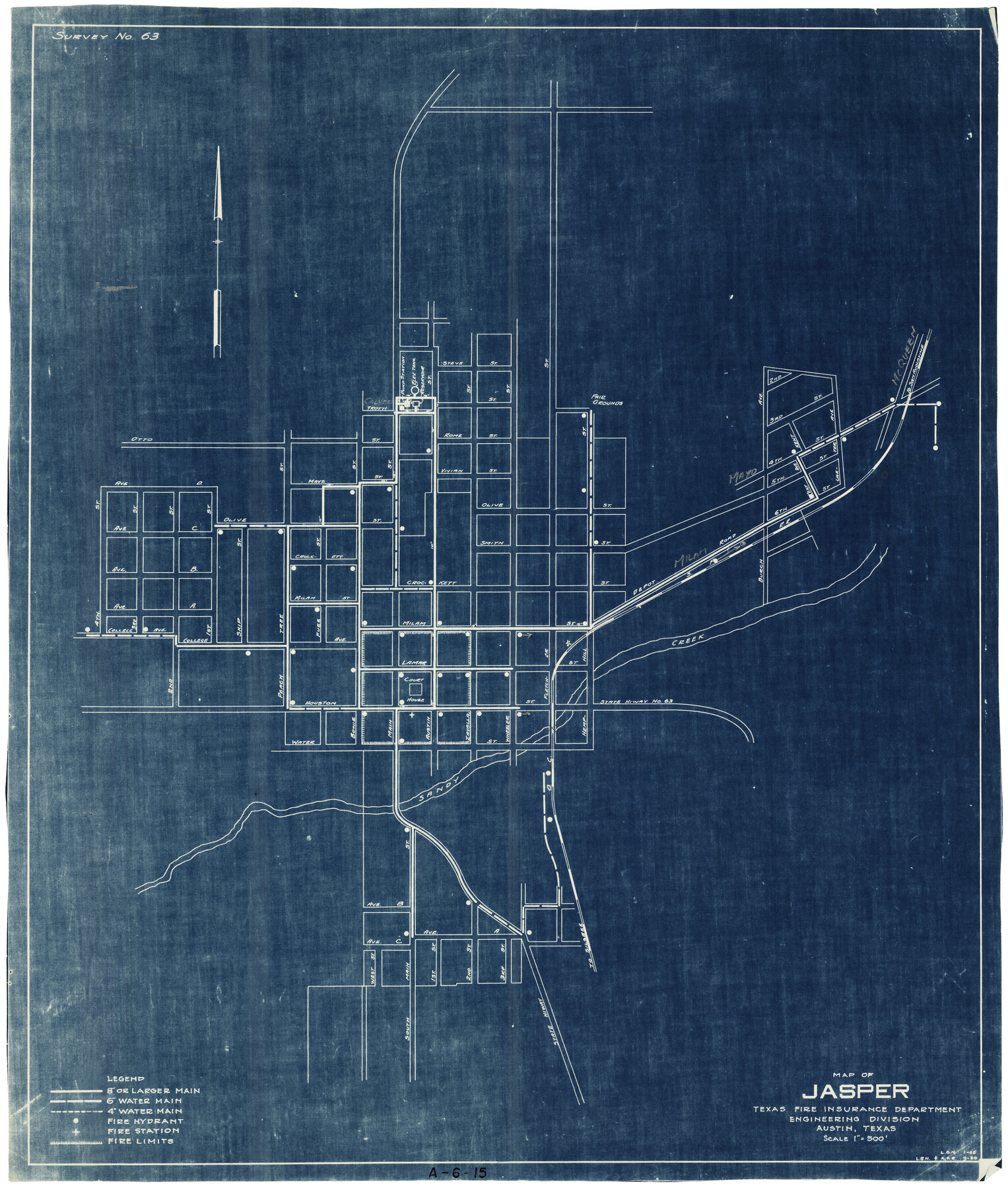
Map of Jasper
A-6-15
-
Map/Doc
2207
-
Collection
General Map Collection
-
Object Dates
1930 (Creation Date)
-
People and Organizations
Texas Fire Insurance Department (Publisher)
-
Counties
Jasper
-
Subjects
City
-
Height x Width
23.7 x 20.1 inches
60.2 x 51.1 cm
-
Medium
blueprint/diazo
-
Scale
1" = 500 feet
-
Comments
Texas Fire Insurance Department, Engineering Division.
Street map showing locations of water mains, fire hydrants and fire station. -
Features
[Road] to San Augustine
State Highway No. 63
Sandy Creek
[Road] to Silsbee
Fairgrounds
Part of: General Map Collection


Starr County Sketch File 46

Print $20.00
- Digital $50.00
Starr County Sketch File 46
1949
Size 23.3 x 26.6 inches
Map/Doc 12343
Map of the Mexican Central Railway and Connections

Print $20.00
- Digital $50.00
Map of the Mexican Central Railway and Connections
1892
Size 22.0 x 26.0 inches
Map/Doc 95742
Gillespie County

Print $40.00
- Digital $50.00
Gillespie County
1887
Size 44.1 x 59.7 inches
Map/Doc 16835
Floyd County Sketch File 20

Print $4.00
- Digital $50.00
Floyd County Sketch File 20
1914
Size 14.5 x 8.9 inches
Map/Doc 22772
Wilson County Sketch File 8

Print $8.00
- Digital $50.00
Wilson County Sketch File 8
1879
Size 10.4 x 8.2 inches
Map/Doc 40413
Yoakum County Sketch File 5

Print $10.00
- Digital $50.00
Yoakum County Sketch File 5
1899
Size 14.3 x 9.0 inches
Map/Doc 40733
Hudspeth County Rolled Sketch 66

Print $20.00
- Digital $50.00
Hudspeth County Rolled Sketch 66
1973
Size 12.0 x 19.0 inches
Map/Doc 6262
Parker County Working Sketch 2

Print $20.00
- Digital $50.00
Parker County Working Sketch 2
1920
Map/Doc 71452
Matagorda County NRC Article 33.136 Sketch 16

Digital $50.00
Matagorda County NRC Article 33.136 Sketch 16
2023
Map/Doc 97256
Jackson County Sketch File 5

Print $4.00
- Digital $50.00
Jackson County Sketch File 5
1876
Size 12.7 x 8.2 inches
Map/Doc 27628
You may also like
Galveston County Rolled Sketch 18

Print $20.00
- Digital $50.00
Galveston County Rolled Sketch 18
1958
Size 24.1 x 32.0 inches
Map/Doc 5956
General Highway Map, Moore County, Texas

Print $20.00
General Highway Map, Moore County, Texas
1961
Size 18.1 x 24.5 inches
Map/Doc 79604
The Republic County of Washington. February 1, 1844

Print $20.00
The Republic County of Washington. February 1, 1844
2020
Size 11.8 x 21.7 inches
Map/Doc 96309
Hale County Sketch File 15

Print $20.00
- Digital $50.00
Hale County Sketch File 15
Size 22.7 x 18.6 inches
Map/Doc 11596
Hutchinson County Rolled Sketch 37A

Print $40.00
- Digital $50.00
Hutchinson County Rolled Sketch 37A
1950
Size 24.7 x 50.5 inches
Map/Doc 9246
Presidio County Rolled Sketch 131A

Print $20.00
- Digital $50.00
Presidio County Rolled Sketch 131A
Size 25.5 x 26.3 inches
Map/Doc 10712
Flight Mission No. BRA-16M, Frame 138, Jefferson County

Print $20.00
- Digital $50.00
Flight Mission No. BRA-16M, Frame 138, Jefferson County
1953
Size 18.7 x 22.3 inches
Map/Doc 85744
Map of Bandera County

Print $20.00
- Digital $50.00
Map of Bandera County
1878
Size 19.3 x 29.4 inches
Map/Doc 3272

Padre Island National Seashore

Print $4.00
- Digital $50.00
Padre Island National Seashore
Size 16.1 x 22.3 inches
Map/Doc 60535
[H. & G. N. Block B4]
![90275, [H. & G. N. Block B4], Twichell Survey Records](https://historictexasmaps.com/wmedia_w700/maps/90275-1.tif.jpg)
Print $20.00
- Digital $50.00
[H. & G. N. Block B4]
Size 21.4 x 18.2 inches
Map/Doc 90275
Orange County Working Sketch 49

Print $20.00
- Digital $50.00
Orange County Working Sketch 49
1991
Size 29.7 x 31.8 inches
Map/Doc 71381