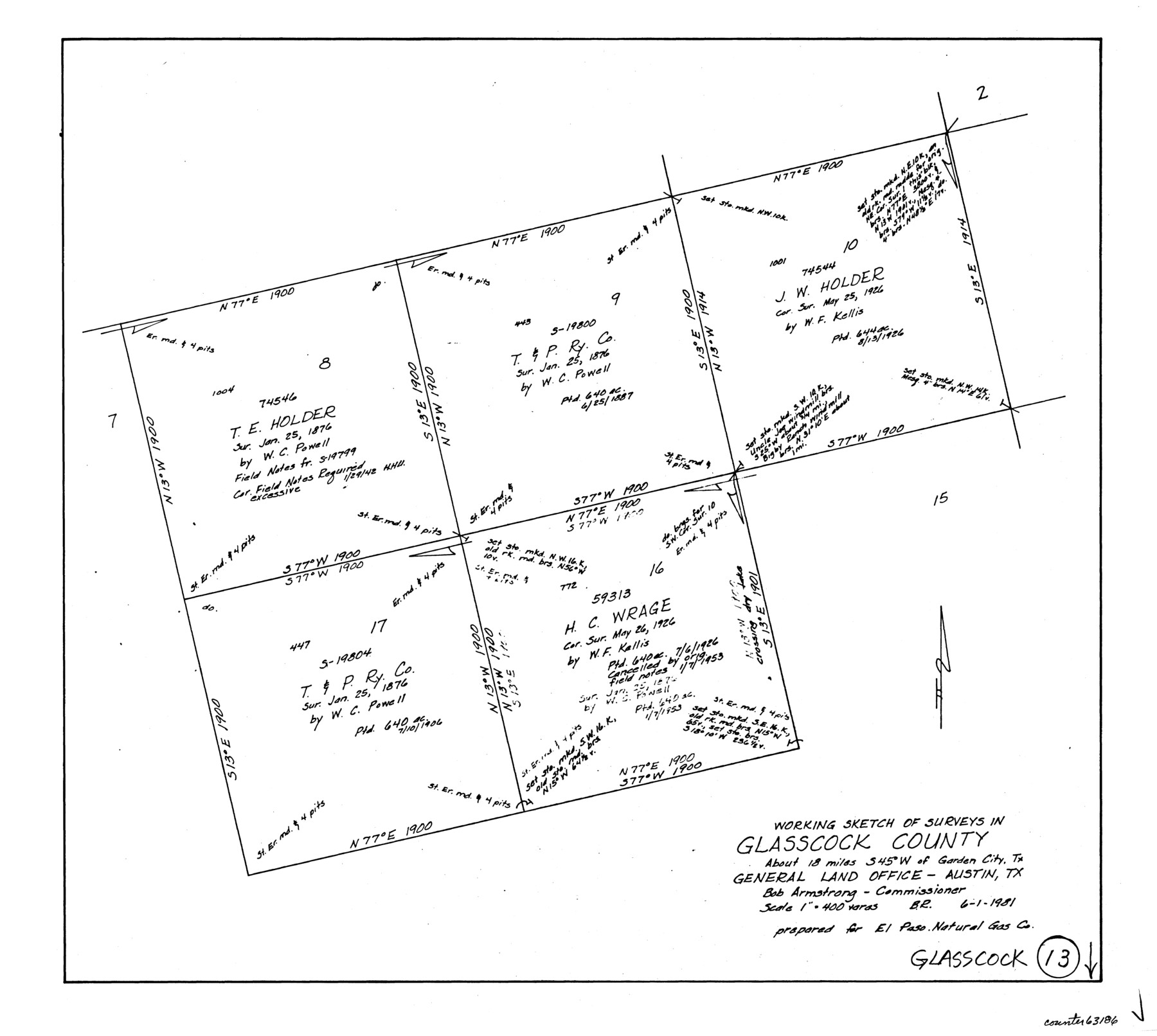
Glasscock County Working Sketch 13
-
Map/Doc
63186
-
Collection
General Map Collection
-
Object Dates
6/1/1981 (Creation Date)
-
People and Organizations
Beverly Robison (Draftsman)
-
Counties
Glasscock
-
Subjects
Surveying Working Sketch
-
Height x Width
17.5 x 19.5 inches
44.5 x 49.5 cm
-
Scale
1" = 400 varas
Part of: General Map Collection
Clason's Oil Map of Texas and Oklahoma showing the location and approximate area of the oil and gas fields

Print $20.00
- Digital $50.00
Clason's Oil Map of Texas and Oklahoma showing the location and approximate area of the oil and gas fields
1919
Size 22.4 x 24.5 inches
Map/Doc 97158
Anderson County Working Sketch 17

Print $40.00
- Digital $50.00
Anderson County Working Sketch 17
1941
Size 30.3 x 48.8 inches
Map/Doc 67017
Presidio County Rolled Sketch 131A

Print $20.00
- Digital $50.00
Presidio County Rolled Sketch 131A
Size 25.5 x 26.3 inches
Map/Doc 10712

Hutchinson County Working Sketch 14

Print $20.00
- Digital $50.00
Hutchinson County Working Sketch 14
1930
Size 18.4 x 25.8 inches
Map/Doc 66372
Reagan County Working Sketch 13

Print $40.00
- Digital $50.00
Reagan County Working Sketch 13
1948
Size 23.8 x 50.8 inches
Map/Doc 71853
Flight Mission No. BRA-16M, Frame 60, Jefferson County

Print $20.00
- Digital $50.00
Flight Mission No. BRA-16M, Frame 60, Jefferson County
1953
Size 18.6 x 22.3 inches
Map/Doc 85677
Flight Mission No. BRA-7M, Frame 77, Jefferson County

Print $20.00
- Digital $50.00
Flight Mission No. BRA-7M, Frame 77, Jefferson County
1953
Size 16.0 x 16.0 inches
Map/Doc 85499
El Paso County Rolled Sketch 58

Print $20.00
- Digital $50.00
El Paso County Rolled Sketch 58
1987
Size 18.6 x 24.6 inches
Map/Doc 5851
Burnet County Boundary File 1

Print $28.00
- Digital $50.00
Burnet County Boundary File 1
Size 12.8 x 8.3 inches
Map/Doc 50844
Edwards County Sketch File 46

Print $26.00
- Digital $50.00
Edwards County Sketch File 46
1954
Size 11.3 x 8.7 inches
Map/Doc 21792
Kerr County Working Sketch 29

Print $20.00
- Digital $50.00
Kerr County Working Sketch 29
1972
Size 46.3 x 33.1 inches
Map/Doc 70060
You may also like
Hudspeth County Working Sketch 23

Print $40.00
- Digital $50.00
Hudspeth County Working Sketch 23
1967
Size 52.7 x 34.3 inches
Map/Doc 69650
Henderson County Working Sketch 7

Print $20.00
- Digital $50.00
Henderson County Working Sketch 7
1922
Size 12.5 x 18.8 inches
Map/Doc 66140
The Republic County of Goliad. Proposed, Late Fall 1837-December 31, 1838

Print $20.00
The Republic County of Goliad. Proposed, Late Fall 1837-December 31, 1838
2020
Size 15.1 x 21.7 inches
Map/Doc 96148
Young County Working Sketch 14

Print $20.00
- Digital $50.00
Young County Working Sketch 14
1944
Size 15.3 x 16.0 inches
Map/Doc 62037
Henderson County Sketch File 21

Print $20.00
- Digital $50.00
Henderson County Sketch File 21
1941
Size 27.8 x 17.9 inches
Map/Doc 11758
Runnels County Working Sketch 10

Print $20.00
- Digital $50.00
Runnels County Working Sketch 10
1948
Size 42.0 x 39.8 inches
Map/Doc 63606
Flight Mission No. CUG-2P, Frame 85, Kleberg County

Print $20.00
- Digital $50.00
Flight Mission No. CUG-2P, Frame 85, Kleberg County
1956
Size 18.5 x 22.2 inches
Map/Doc 86217
Nueces County Rolled Sketch 65

Print $20.00
- Digital $50.00
Nueces County Rolled Sketch 65
1979
Size 19.5 x 26.2 inches
Map/Doc 6917
Starr County Rolled Sketch 16

Print $20.00
- Digital $50.00
Starr County Rolled Sketch 16
1913
Size 18.6 x 21.9 inches
Map/Doc 7801
Webb County Working Sketch 48

Print $20.00
- Digital $50.00
Webb County Working Sketch 48
1948
Size 28.5 x 41.4 inches
Map/Doc 72413
Motley County Sketch File 7a (N)

Print $40.00
- Digital $50.00
Motley County Sketch File 7a (N)
1895
Size 13.5 x 14.4 inches
Map/Doc 32014
Flight Mission No. BRE-1P, Frame 120, Nueces County

Print $20.00
- Digital $50.00
Flight Mission No. BRE-1P, Frame 120, Nueces County
1956
Size 18.6 x 22.8 inches
Map/Doc 86686