Wood County Sketch File 8
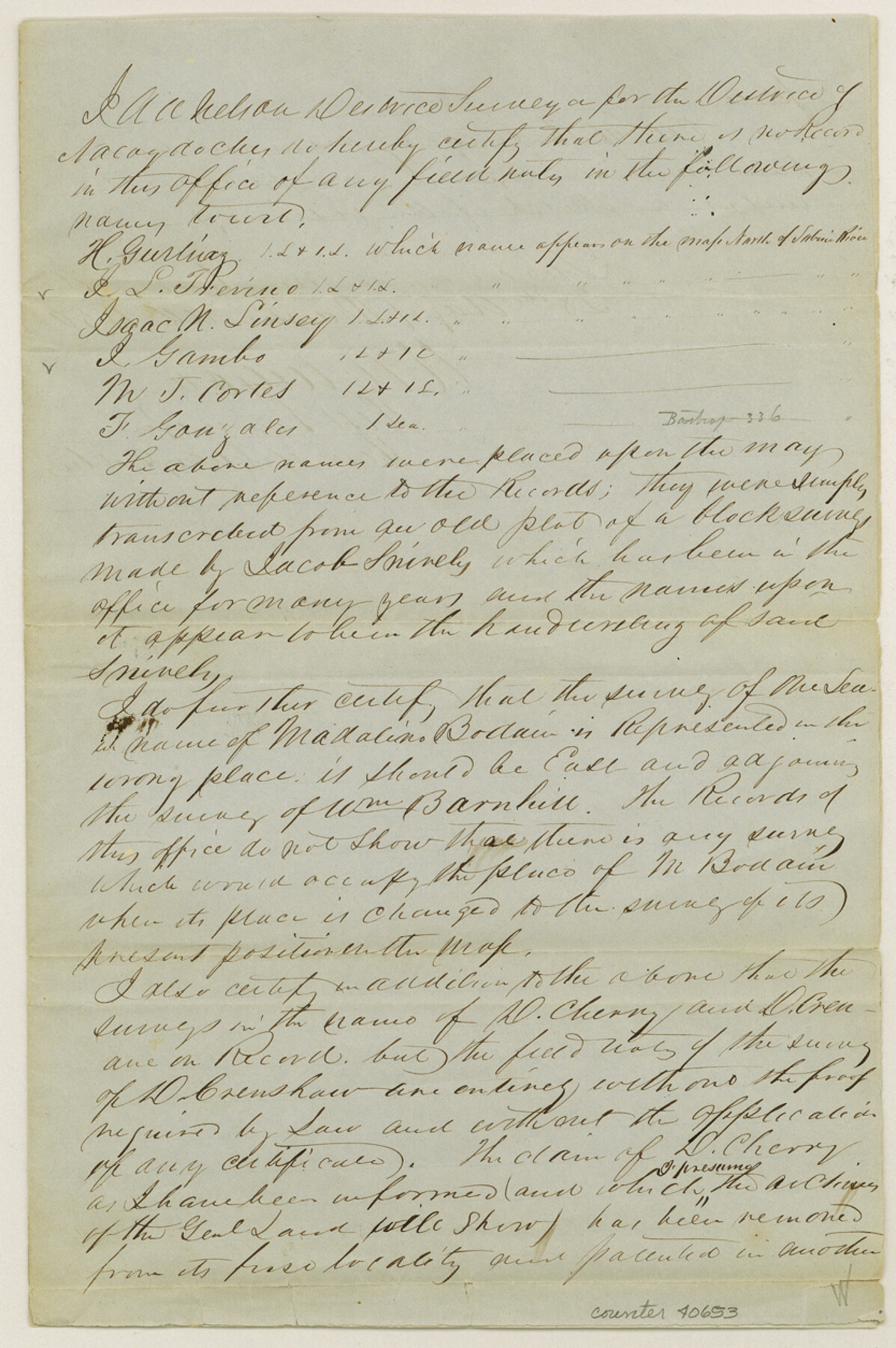
[Certificate of no field notes on record of certain surveys in Wood County]
-
Map/Doc
40653
-
Collection
General Map Collection
-
Object Dates
12/28/1850 (Creation Date)
-
People and Organizations
A.A. Nelson (Surveyor/Engineer)
-
Counties
Wood
-
Subjects
Surveying Sketch File
-
Height x Width
12.5 x 8.3 inches
31.8 x 21.1 cm
-
Medium
paper, manuscript
-
Features
Clear Creek
Dry Creek
Part of: General Map Collection
Flight Mission No. BRA-8M, Frame 119, Jefferson County

Print $20.00
- Digital $50.00
Flight Mission No. BRA-8M, Frame 119, Jefferson County
1953
Size 18.4 x 22.2 inches
Map/Doc 85615
Chambers County Sketch File 23

Print $2.00
- Digital $50.00
Chambers County Sketch File 23
1878
Size 10.0 x 7.9 inches
Map/Doc 17597
Cass County Sketch File 11

Print $6.00
- Digital $50.00
Cass County Sketch File 11
Size 10.4 x 14.4 inches
Map/Doc 17412
Hartley County Sketch File 2

Print $22.00
- Digital $50.00
Hartley County Sketch File 2
Size 8.9 x 13.6 inches
Map/Doc 26085

Fannin County Sketch File 24

Print $4.00
- Digital $50.00
Fannin County Sketch File 24
Size 13.2 x 8.6 inches
Map/Doc 22491
Garza County Working Sketch 5

Print $20.00
- Digital $50.00
Garza County Working Sketch 5
1943
Size 19.4 x 34.7 inches
Map/Doc 63152
Pecos County Rolled Sketch 140

Print $20.00
- Digital $50.00
Pecos County Rolled Sketch 140
1954
Size 28.4 x 38.6 inches
Map/Doc 7275
Grayson County Working Sketch 21

Print $20.00
- Digital $50.00
Grayson County Working Sketch 21
1961
Size 42.6 x 26.5 inches
Map/Doc 63260
Brazoria County Sketch File 2

Print $6.00
- Digital $50.00
Brazoria County Sketch File 2
Size 8.0 x 3.3 inches
Map/Doc 14920
[Sketch for Mineral Application 24072, San Jacinto River]
![65590, [Sketch for Mineral Application 24072, San Jacinto River], General Map Collection](https://historictexasmaps.com/wmedia_w700/maps/65590.tif.jpg)
Print $20.00
- Digital $50.00
[Sketch for Mineral Application 24072, San Jacinto River]
1929
Size 40.8 x 14.7 inches
Map/Doc 65590
Map of Freestone County

Print $20.00
- Digital $50.00
Map of Freestone County
1858
Size 22.3 x 24.1 inches
Map/Doc 3564
You may also like
Arroyo Colorado, La Feria Sheet

Print $40.00
- Digital $50.00
Arroyo Colorado, La Feria Sheet
1929
Size 24.6 x 58.5 inches
Map/Doc 65128
Scrivener's North-west Sub-division, Wichita County, Texas

Print $20.00
- Digital $50.00
Scrivener's North-west Sub-division, Wichita County, Texas
Size 20.0 x 26.0 inches
Map/Doc 91994
Polk County Sketch File 26

Print $12.00
- Digital $50.00
Polk County Sketch File 26
1889
Size 8.5 x 7.1 inches
Map/Doc 34183
Galveston County Sketch File 63

Print $52.00
- Digital $50.00
Galveston County Sketch File 63
Size 11.3 x 8.9 inches
Map/Doc 23681
Gregg County Working Sketch 18

Print $20.00
- Digital $50.00
Gregg County Working Sketch 18
1955
Size 23.3 x 24.0 inches
Map/Doc 63285
Kinney County Working Sketch 56

Print $40.00
- Digital $50.00
Kinney County Working Sketch 56
1987
Size 40.5 x 62.8 inches
Map/Doc 70238
Brewster County Sketch File N-28

Print $40.00
- Digital $50.00
Brewster County Sketch File N-28
Size 23.4 x 24.3 inches
Map/Doc 10973
Coryell County Sketch File 6

Print $4.00
- Digital $50.00
Coryell County Sketch File 6
1858
Size 8.2 x 9.8 inches
Map/Doc 19347

General Highway Map, Fort Bend County, Texas

Print $20.00
General Highway Map, Fort Bend County, Texas
1961
Size 18.1 x 24.5 inches
Map/Doc 79469
Knox County Rolled Sketch 21

Print $20.00
- Digital $50.00
Knox County Rolled Sketch 21
1955
Size 18.0 x 36.4 inches
Map/Doc 6561
Roberts County

Print $20.00
- Digital $50.00
Roberts County
1900
Size 43.4 x 42.0 inches
Map/Doc 63002