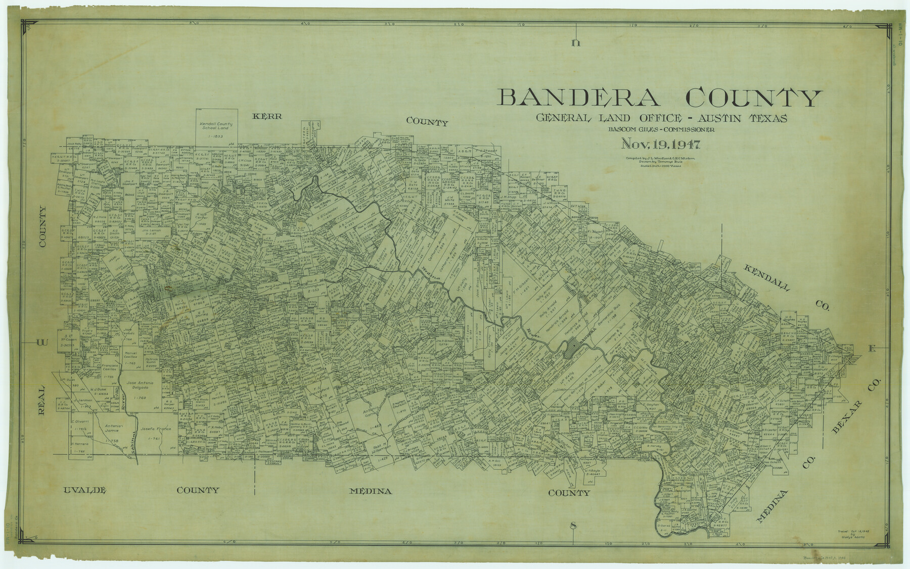
Bandera County
RM-1-10
-
Map/Doc
1777
-
Collection
General Map Collection
-
Object Dates
1947/11/19 (Creation Date)
-
People and Organizations
Texas General Land Office (Publisher)
Tommye Buie (Draftsman)
J.L. Woodland (Compiler)
R.C. Wisdom (Compiler)
-
Counties
Bandera
-
Subjects
County
-
Height x Width
34.2 x 54.7 inches
86.9 x 138.9 cm
-
Comments
Traced October 14, 1948 by Gladys Adams.
Part of: General Map Collection
Castro County Sketch File 5a

Print $8.00
- Digital $50.00
Castro County Sketch File 5a
1904
Size 11.2 x 8.7 inches
Map/Doc 17491
Brazoria County Sketch File 6a

Print $40.00
- Digital $50.00
Brazoria County Sketch File 6a
1862
Size 17.6 x 12.6 inches
Map/Doc 10949
Dallas County Sketch File 14

Print $22.00
- Digital $50.00
Dallas County Sketch File 14
1859
Size 8.2 x 7.6 inches
Map/Doc 20428
Hardeman County Sketch File 7

Print $10.00
- Digital $50.00
Hardeman County Sketch File 7
Size 8.9 x 14.1 inches
Map/Doc 24997
Hardin County Working Sketch 9

Print $20.00
- Digital $50.00
Hardin County Working Sketch 9
1928
Size 21.7 x 21.1 inches
Map/Doc 63407
Map Showing Resurvey of Capitol Leagues, Deaf Smith Co.

Print $20.00
- Digital $50.00
Map Showing Resurvey of Capitol Leagues, Deaf Smith Co.
1918
Size 42.5 x 31.9 inches
Map/Doc 1756
[Galveston, Harrisburg & San Antonio from El Paso-Presidio county boundary to Presidio-Pecos county boundary]
![64718, [Galveston, Harrisburg & San Antonio from El Paso-Presidio county boundary to Presidio-Pecos county boundary], General Map Collection](https://historictexasmaps.com/wmedia_w700/maps/64718.tif.jpg)
Print $40.00
- Digital $50.00
[Galveston, Harrisburg & San Antonio from El Paso-Presidio county boundary to Presidio-Pecos county boundary]
Size 106.1 x 44.3 inches
Map/Doc 64718
Flight Mission No. CGI-3N, Frame 108, Cameron County

Print $20.00
- Digital $50.00
Flight Mission No. CGI-3N, Frame 108, Cameron County
1954
Size 18.6 x 22.2 inches
Map/Doc 84588
Hale County Sketch File 18

Print $4.00
- Digital $50.00
Hale County Sketch File 18
1903
Size 11.0 x 8.6 inches
Map/Doc 24749
Maps of Gulf Intracoastal Waterway, Texas - Sabine River to the Rio Grande and connecting waterways including ship channels

Print $20.00
- Digital $50.00
Maps of Gulf Intracoastal Waterway, Texas - Sabine River to the Rio Grande and connecting waterways including ship channels
1966
Size 14.5 x 22.2 inches
Map/Doc 61963
Flight Mission No. DIX-10P, Frame 167, Aransas County

Print $20.00
- Digital $50.00
Flight Mission No. DIX-10P, Frame 167, Aransas County
1956
Size 18.6 x 22.3 inches
Map/Doc 83957
Hudspeth County Working Sketch 22

Print $40.00
- Digital $50.00
Hudspeth County Working Sketch 22
1967
Size 45.8 x 62.8 inches
Map/Doc 66304
You may also like
Hockley County

Print $20.00
- Digital $50.00
Hockley County
1900
Size 27.0 x 20.7 inches
Map/Doc 6215
Young County Sketch File 9

Print $4.00
- Digital $50.00
Young County Sketch File 9
1859
Size 8.5 x 7.8 inches
Map/Doc 40864
Throckmorton County

Print $20.00
- Digital $50.00
Throckmorton County
1885
Size 24.9 x 18.7 inches
Map/Doc 4080
Crockett County

Print $40.00
- Digital $50.00
Crockett County
1882
Size 57.1 x 67.6 inches
Map/Doc 82212
Rusk County Working Sketch 21

Print $20.00
- Digital $50.00
Rusk County Working Sketch 21
1953
Size 27.6 x 28.3 inches
Map/Doc 63657
Sutton County Rolled Sketch 54

Print $20.00
- Digital $50.00
Sutton County Rolled Sketch 54
Size 32.4 x 27.7 inches
Map/Doc 7894
[10th St and 29th St Groins - Galveston]
![73621, [10th St and 29th St Groins - Galveston], General Map Collection](https://historictexasmaps.com/wmedia_w700/maps/73621-1.tif.jpg)
Print $6.00
- Digital $50.00
[10th St and 29th St Groins - Galveston]
1983
Size 25.6 x 35.2 inches
Map/Doc 73621
Northeast Part of Crockett County

Print $20.00
- Digital $50.00
Northeast Part of Crockett County
1976
Size 35.6 x 46.1 inches
Map/Doc 73120
Parker County Boundary File 3a

Print $34.00
- Digital $50.00
Parker County Boundary File 3a
Size 11.2 x 8.8 inches
Map/Doc 57840
McMullen County Working Sketch 44

Print $20.00
- Digital $50.00
McMullen County Working Sketch 44
1981
Size 35.1 x 41.2 inches
Map/Doc 70745
Flight Mission No. CGI-3N, Frame 175, Cameron County

Print $20.00
- Digital $50.00
Flight Mission No. CGI-3N, Frame 175, Cameron County
1954
Size 18.6 x 22.3 inches
Map/Doc 84639
Glasscock County Rolled Sketch 8

Print $20.00
- Digital $50.00
Glasscock County Rolled Sketch 8
1951
Size 37.3 x 31.1 inches
Map/Doc 9057