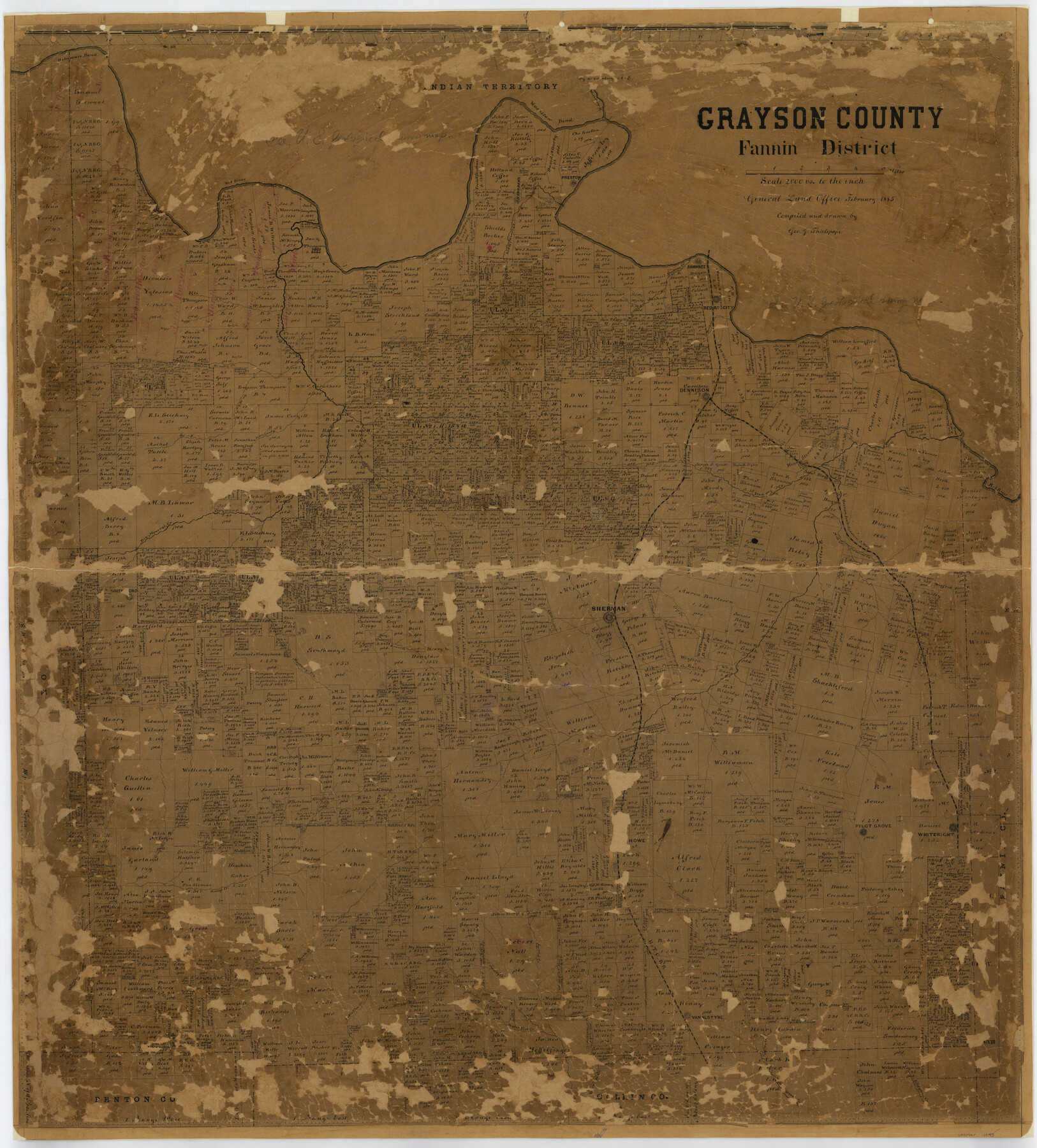
Grayson County
-
Map/Doc
16840
-
Collection
General Map Collection
-
Object Dates
2/1885 (Creation Date)
-
People and Organizations
George J. Thielepape (Draftsman)
-
Counties
Grayson
-
Subjects
County
-
Height x Width
39.9 x 35.8 inches
101.4 x 90.9 cm
-
Comments
Conservation funded in 2002 with donation from William Windsor Richardson.
-
Features
Dennison
Squirrel Creek
Little Mineral Creek
Preston
Shawnee Creek
Sherman
Howe
Fort White Creek
Van Alstyne
Iron Ore Creek
Washitaw Bend
Pilot Grove
Pewter Fist Creek
Shawnee
Red River City
Shannon Creek
Choctaw Bayou
Cornelius Creek
Calf Creek
Post Oak Creek
Cedar Creek
Whitewright
Sistergrove Creek
Pilotgrove Creek
Buck Creek
Red River
H&TC
D&SE
Big Mineral Creek
Whitesboro
Salt Creek
Jordan Creek
Spring Creek
Range Creek
Strickland Creek
Little Elm Creek
Delaware Bend
Salty Lick Creek
Mustang Fork [of Big Mineral Creek]
Deaver's Fork [of Big Mineral Creek]
Bason Springs
Little Sandy Creek
Big Sandy Creek
Brushy Creek
Duck Creek
Mill Creek
Harris Fork [of Big Mineral Creek]
Part of: General Map Collection
Dickens County Sketch File 37

Print $8.00
- Digital $50.00
Dickens County Sketch File 37
Size 10.3 x 8.3 inches
Map/Doc 21044
Matagorda County NRC Article 33.136 Sketch 9

Print $28.00
- Digital $50.00
Matagorda County NRC Article 33.136 Sketch 9
2011
Size 24.0 x 36.0 inches
Map/Doc 94811
Martin County Sketch File 4

Print $20.00
- Digital $50.00
Martin County Sketch File 4
Size 26.9 x 19.8 inches
Map/Doc 12027
Pecos County Rolled Sketch 44

Print $20.00
- Digital $50.00
Pecos County Rolled Sketch 44
1912
Size 22.9 x 37.6 inches
Map/Doc 7222
Hardeman County Rolled Sketch 15

Print $20.00
- Digital $50.00
Hardeman County Rolled Sketch 15
1890
Size 18.0 x 23.0 inches
Map/Doc 6072
Coryell County Sketch File 14

Print $6.00
- Digital $50.00
Coryell County Sketch File 14
1873
Size 5.0 x 7.6 inches
Map/Doc 19368
Travis County Sketch File 34

Print $26.00
- Digital $50.00
Travis County Sketch File 34
1888
Size 26.8 x 27.9 inches
Map/Doc 12461
[Map Showing Location and Right of Way of Proposed Groins]
![73623, [Map Showing Location and Right of Way of Proposed Groins], General Map Collection](https://historictexasmaps.com/wmedia_w700/maps/73623-1.tif.jpg)
Print $4.00
- Digital $50.00
[Map Showing Location and Right of Way of Proposed Groins]
Size 13.4 x 24.4 inches
Map/Doc 73623
San Saba County Sketch File 17

Print $8.00
- Digital $50.00
San Saba County Sketch File 17
1918
Size 11.4 x 8.8 inches
Map/Doc 36456
Lamar County Working Sketch 7

Print $20.00
- Digital $50.00
Lamar County Working Sketch 7
1964
Size 18.7 x 17.6 inches
Map/Doc 70268
Plat Showing the Development of Texas Counties from the Original Land Districts

Print $40.00
- Digital $50.00
Plat Showing the Development of Texas Counties from the Original Land Districts
Size 49.6 x 29.5 inches
Map/Doc 73616
Jim Wells County Boundary File 1a

Print $80.00
- Digital $50.00
Jim Wells County Boundary File 1a
Size 60.8 x 13.5 inches
Map/Doc 55542
You may also like
Erath County Rolled Sketch 7

Print $20.00
- Digital $50.00
Erath County Rolled Sketch 7
Size 19.2 x 24.4 inches
Map/Doc 88881
Presidio County Sketch File 6a

Print $2.00
- Digital $50.00
Presidio County Sketch File 6a
Size 7.9 x 6.6 inches
Map/Doc 34437
Tom Green County Rolled Sketch 4

Print $20.00
- Digital $50.00
Tom Green County Rolled Sketch 4
Size 28.2 x 23.6 inches
Map/Doc 7994
Travis County Appraisal District Plat Map 2_0404

Print $20.00
- Digital $50.00
Travis County Appraisal District Plat Map 2_0404
Size 20.5 x 24.1 inches
Map/Doc 94228
Jeff Davis County Sketch File 13

Print $14.00
- Digital $50.00
Jeff Davis County Sketch File 13
1889
Size 13.9 x 8.5 inches
Map/Doc 27941
Map of Trinity Co.

Print $20.00
- Digital $50.00
Map of Trinity Co.
1896
Size 40.7 x 39.1 inches
Map/Doc 63079
Flight Mission No. BRE-2P, Frame 136, Nueces County

Print $20.00
- Digital $50.00
Flight Mission No. BRE-2P, Frame 136, Nueces County
1956
Size 18.5 x 22.6 inches
Map/Doc 86809
Concho County Rolled Sketch 18

Print $20.00
- Digital $50.00
Concho County Rolled Sketch 18
1955
Size 11.4 x 18.3 inches
Map/Doc 5553
Callahan County Working Sketch 8

Print $20.00
- Digital $50.00
Callahan County Working Sketch 8
Size 30.5 x 23.7 inches
Map/Doc 67890
El Paso County Sketch File 34

Print $82.00
- Digital $50.00
El Paso County Sketch File 34
1984
Size 14.3 x 8.9 inches
Map/Doc 22129
Map of Taylor, Bastrop & Houston Railroad in Williamson, Travis, & Bastrop Counties, Texas

Print $20.00
- Digital $50.00
Map of Taylor, Bastrop & Houston Railroad in Williamson, Travis, & Bastrop Counties, Texas
1887
Size 26.3 x 17.8 inches
Map/Doc 65468
Comal County Working Sketch 10

Print $20.00
- Digital $50.00
Comal County Working Sketch 10
1974
Size 28.8 x 27.9 inches
Map/Doc 68176