Brewster County Sketch File N-18
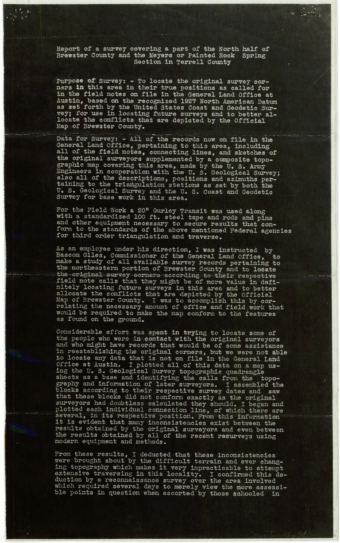
Report of a survey covering a part of the north half of Brewster County and the Meyers or Painted Rock Spring section in Terrell County
-
Map/Doc
15690
-
Collection
General Map Collection
-
Object Dates
1942/7/1 (Creation Date)
1941 (Survey Date)
1942 (Survey Date)
1942/8/17 (File Date)
-
People and Organizations
M.P. Ball (Surveyor/Engineer)
-
Counties
Brewster Terrell
-
Subjects
Surveying Sketch File
-
Height x Width
14.2 x 8.9 inches
36.1 x 22.6 cm
-
Medium
photostat, negative
-
Features
Stairway Mountain
Iron Mountain
Maravillas Creek
Rio Grande
Reagan Canyon
Bullis Gap
San Francisco Creek
Maravillas Gap
Sierra Santiago
Maxan [Switch]
Dryden
Meyers Creek
Painted Rock Spring
Part of: General Map Collection
Shelby County Working Sketch 7

Print $20.00
- Digital $50.00
Shelby County Working Sketch 7
1942
Size 40.2 x 44.2 inches
Map/Doc 63860
[G.C. and S. F. R.R. Co. Through Bosque County from McLennan Co. and E. to Hill Co. Station M. P. 259 to M. P. 297]
![64564, [G.C. and S. F. R.R. Co. Through Bosque County from McLennan Co. and E. to Hill Co. Station M. P. 259 to M. P. 297], General Map Collection](https://historictexasmaps.com/wmedia_w700/maps/64564-1.tif.jpg)
Print $40.00
- Digital $50.00
[G.C. and S. F. R.R. Co. Through Bosque County from McLennan Co. and E. to Hill Co. Station M. P. 259 to M. P. 297]
1898
Size 22.4 x 101.5 inches
Map/Doc 64564
Flight Mission No. DAG-21K, Frame 88, Matagorda County

Print $20.00
- Digital $50.00
Flight Mission No. DAG-21K, Frame 88, Matagorda County
1952
Size 18.6 x 22.4 inches
Map/Doc 86417
Kenedy County Aerial Photograph Index Sheet 1

Print $20.00
- Digital $50.00
Kenedy County Aerial Photograph Index Sheet 1
1943
Size 23.3 x 19.5 inches
Map/Doc 83713
Palo Pinto County Sketch File 25

Print $26.00
- Digital $50.00
Palo Pinto County Sketch File 25
1874
Size 10.1 x 8.9 inches
Map/Doc 33404
Cooke County Sketch File 26

Print $4.00
- Digital $50.00
Cooke County Sketch File 26
1872
Size 5.9 x 8.2 inches
Map/Doc 19277
Jefferson County Sketch File 56

Print $34.00
- Digital $50.00
Jefferson County Sketch File 56
2007
Map/Doc 93427
Walker County Working Sketch 3

Print $20.00
- Digital $50.00
Walker County Working Sketch 3
1931
Size 26.4 x 18.2 inches
Map/Doc 72283
Ochiltree County Working Sketch 4

Print $40.00
- Digital $50.00
Ochiltree County Working Sketch 4
1961
Size 89.2 x 38.4 inches
Map/Doc 71317
Montague County Working Sketch 42

Print $20.00
- Digital $50.00
Montague County Working Sketch 42
2009
Size 19.9 x 25.4 inches
Map/Doc 89004
Throckmorton County Sketch File 5a

Print $22.00
- Digital $50.00
Throckmorton County Sketch File 5a
Size 8.0 x 7.8 inches
Map/Doc 38075
Culberson County Rolled Sketch 54

Print $40.00
- Digital $50.00
Culberson County Rolled Sketch 54
1968
Size 59.0 x 29.4 inches
Map/Doc 10300
You may also like
Dimmit County Sketch File 11

Print $12.00
- Digital $50.00
Dimmit County Sketch File 11
1880
Size 12.9 x 8.2 inches
Map/Doc 21075
Haskell County Rolled Sketch 13

Print $3.00
- Digital $50.00
Haskell County Rolled Sketch 13
1991
Size 11.0 x 17.1 inches
Map/Doc 6171
No. IX - Outline map of the vicinity of Corpus Christi

Print $20.00
- Digital $50.00
No. IX - Outline map of the vicinity of Corpus Christi
Size 24.9 x 18.2 inches
Map/Doc 72966
Hays County Sketch File AB

Print $16.00
- Digital $50.00
Hays County Sketch File AB
1891
Size 6.3 x 8.7 inches
Map/Doc 26189
Glasscock County Rolled Sketch 6

Print $20.00
- Digital $50.00
Glasscock County Rolled Sketch 6
1946
Size 19.9 x 22.5 inches
Map/Doc 6017
[Surveys in Milam District between the Bosque and Brazos Rivers]
![3, [Surveys in Milam District between the Bosque and Brazos Rivers], General Map Collection](https://historictexasmaps.com/wmedia_w700/maps/3.tif.jpg)
Print $20.00
- Digital $50.00
[Surveys in Milam District between the Bosque and Brazos Rivers]
1847
Size 15.8 x 12.2 inches
Map/Doc 3
La Salle County Rolled Sketch 4

Print $20.00
- Digital $50.00
La Salle County Rolled Sketch 4
1937
Size 20.9 x 27.5 inches
Map/Doc 6569
Galveston County NRC Article 33.136 Sketch 32

Print $26.00
- Digital $50.00
Galveston County NRC Article 33.136 Sketch 32
2005
Size 24.5 x 36.8 inches
Map/Doc 83173
Nueces County Rolled Sketch 89

Print $235.00
Nueces County Rolled Sketch 89
1983
Size 18.0 x 24.2 inches
Map/Doc 6991
A New, Plaine, and Exact map of America : described by N.I. Visscher, and don into English, enlarged, and corrected, according to I. Blaeu, with the habits of the countries, and the manner of the cheife Citties, the like never before

Print $20.00
- Digital $50.00
A New, Plaine, and Exact map of America : described by N.I. Visscher, and don into English, enlarged, and corrected, according to I. Blaeu, with the habits of the countries, and the manner of the cheife Citties, the like never before
1658
Size 16.4 x 20.9 inches
Map/Doc 96787
Williamson County

Print $40.00
- Digital $50.00
Williamson County
1946
Size 39.0 x 56.3 inches
Map/Doc 73326
Denton County Rolled Sketch 6

Print $20.00
- Digital $50.00
Denton County Rolled Sketch 6
1983
Size 25.4 x 37.2 inches
Map/Doc 5702