Wharton County Sketch File 24
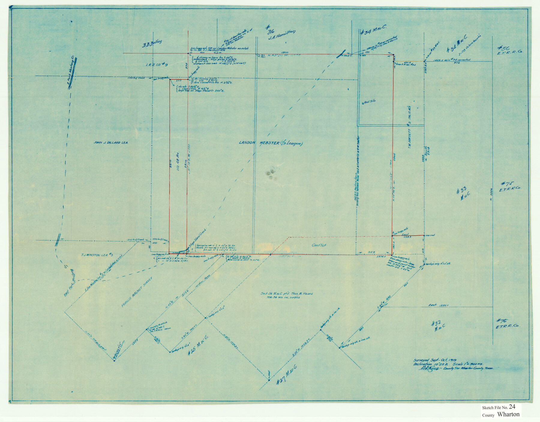
[Sketch of the Landon Webster 1/3 league survey and surrounding area southwest from Wharton]
-
Map/Doc
12668
-
Collection
General Map Collection
-
Object Dates
1919 (Creation Date)
11/26/1975 (File Date)
-
People and Organizations
B.D. King (Surveyor/Engineer)
-
Counties
Wharton
-
Subjects
Surveying Sketch File
-
Height x Width
19.9 x 25.5 inches
50.6 x 64.8 cm
-
Medium
blueprint/diazo
-
Scale
1" = 300 varas
-
Features
East Fork of Mustang Creek
Stage Stand Creek
Part of: General Map Collection
Map of Armstrong County

Print $20.00
- Digital $50.00
Map of Armstrong County
1886
Size 23.0 x 18.6 inches
Map/Doc 3244
Goliad County Working Sketch 21

Print $20.00
- Digital $50.00
Goliad County Working Sketch 21
1961
Size 42.9 x 39.6 inches
Map/Doc 63211
Culberson County Working Sketch 49

Print $40.00
- Digital $50.00
Culberson County Working Sketch 49
1972
Size 49.2 x 37.6 inches
Map/Doc 68503
Gulf of Mexico

Print $20.00
- Digital $50.00
Gulf of Mexico
1905
Size 18.3 x 26.8 inches
Map/Doc 72652
Young County Working Sketch 26

Print $20.00
- Digital $50.00
Young County Working Sketch 26
1982
Size 25.4 x 22.9 inches
Map/Doc 62049
Map of Taylor County Travis- Young- Bexar- Land District

Print $20.00
- Digital $50.00
Map of Taylor County Travis- Young- Bexar- Land District
1859
Size 25.1 x 20.4 inches
Map/Doc 4071
Flight Mission No. CRC-4R, Frame 98, Chambers County

Print $20.00
- Digital $50.00
Flight Mission No. CRC-4R, Frame 98, Chambers County
1956
Size 18.6 x 22.3 inches
Map/Doc 84895
Pecos County Sketch File 35

Print $4.00
- Digital $50.00
Pecos County Sketch File 35
Size 8.9 x 15.3 inches
Map/Doc 33716
Kimble County Working Sketch 3

Print $20.00
- Digital $50.00
Kimble County Working Sketch 3
1897
Size 16.4 x 21.4 inches
Map/Doc 70071
Reeves County Working Sketch 50

Print $20.00
- Digital $50.00
Reeves County Working Sketch 50
1974
Size 45.3 x 30.4 inches
Map/Doc 63493
Flight Mission No. DAG-22K, Frame 73, Matagorda County

Print $20.00
- Digital $50.00
Flight Mission No. DAG-22K, Frame 73, Matagorda County
1953
Size 18.7 x 22.4 inches
Map/Doc 86460
Hemphill County Working Sketch 27

Print $40.00
- Digital $50.00
Hemphill County Working Sketch 27
1974
Size 50.7 x 43.5 inches
Map/Doc 66122
You may also like
Anderson County Sketch File 14

Print $4.00
- Digital $50.00
Anderson County Sketch File 14
1857
Size 12.7 x 8.0 inches
Map/Doc 12779

Flight Mission No. BRA-3M, Frame 128, Jefferson County

Print $20.00
- Digital $50.00
Flight Mission No. BRA-3M, Frame 128, Jefferson County
1953
Size 18.5 x 22.3 inches
Map/Doc 85402
Parker County Working Sketch 12

Print $20.00
- Digital $50.00
Parker County Working Sketch 12
1974
Map/Doc 71462
Milam Empresario Colony. January 12, 1826

Print $20.00
Milam Empresario Colony. January 12, 1826
2020
Size 14.2 x 21.8 inches
Map/Doc 96000
Tom Green County Sketch File 65

Print $18.00
- Digital $50.00
Tom Green County Sketch File 65
1892
Size 13.3 x 8.4 inches
Map/Doc 38227
Map of the United States, Canada and a part of Mexico to illustrate Olney's school geography

Print $20.00
- Digital $50.00
Map of the United States, Canada and a part of Mexico to illustrate Olney's school geography
1844
Size 12.1 x 19.0 inches
Map/Doc 93537
Webb County Rolled Sketch EF2

Print $20.00
- Digital $50.00
Webb County Rolled Sketch EF2
1932
Size 40.4 x 29.9 inches
Map/Doc 8224

Controlled Mosaic by Jack Amman Photogrammetric Engineers, Inc - Sheet 20

Print $20.00
- Digital $50.00
Controlled Mosaic by Jack Amman Photogrammetric Engineers, Inc - Sheet 20
1954
Size 19.3 x 24.0 inches
Map/Doc 83469
[T. & P. Block 44, Township 1S]
![90818, [T. & P. Block 44, Township 1S], Twichell Survey Records](https://historictexasmaps.com/wmedia_w700/maps/90818-2.tif.jpg)
Print $3.00
- Digital $50.00
[T. & P. Block 44, Township 1S]
Size 9.3 x 11.9 inches
Map/Doc 90818
Burnet County Sketch File 27b

Print $7.00
- Digital $50.00
Burnet County Sketch File 27b
1876
Size 10.3 x 8.1 inches
Map/Doc 16737