Pecos County Sketch File 81
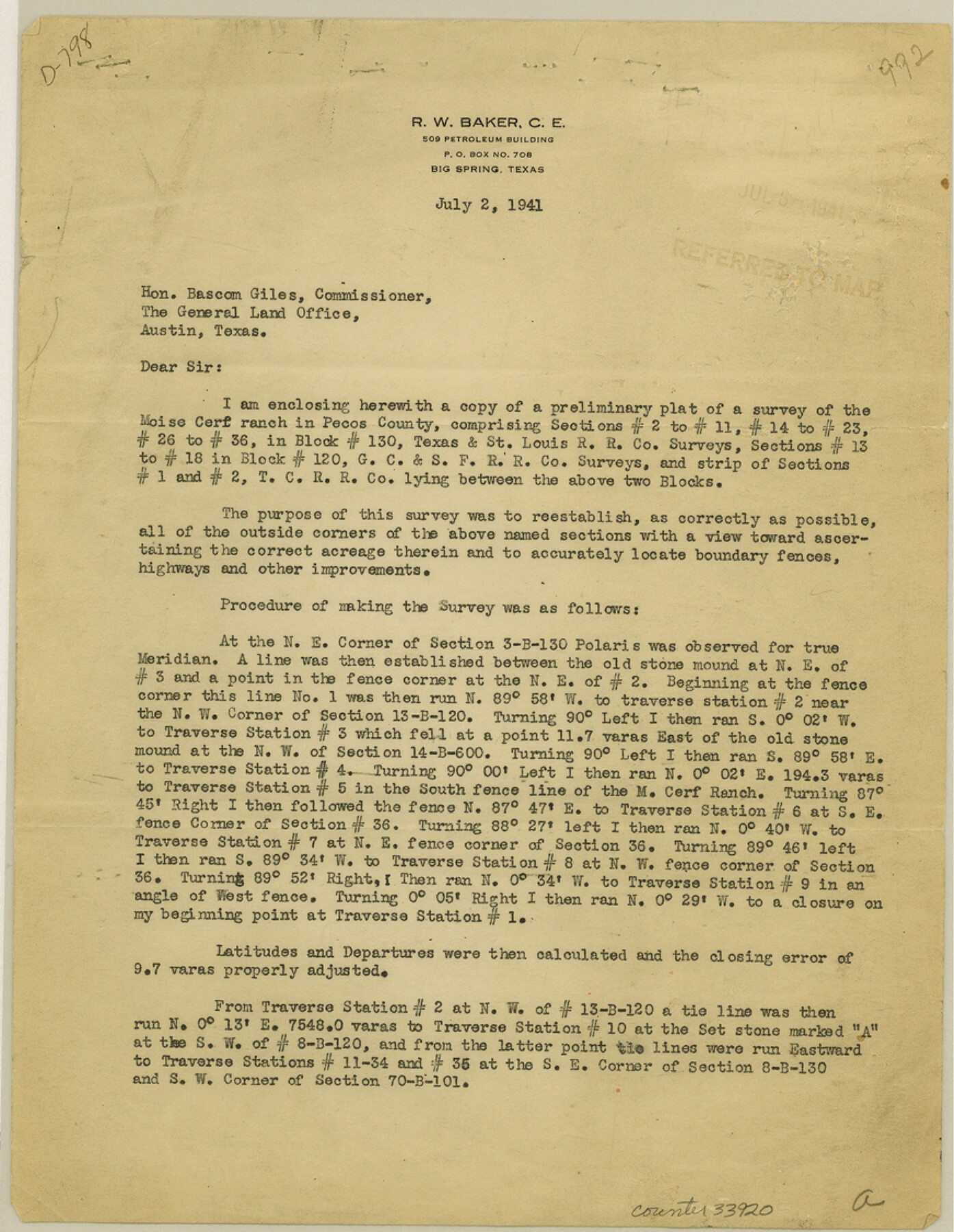
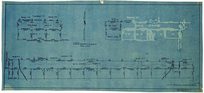
[Report of Moise Cerf Ranch - parts of Block 130, T. & S. L. and Block 120, G. C. & S. F.]
-
Map/Doc
33920
-
Collection
General Map Collection
-
Object Dates
1941/7/2 (Creation Date)
1944/11/2 (File Date)
1941/7/2 (Correspondence Date)
1889 (Survey Date)
1881 (Survey Date)
1941/7/18 (Correspondence Date)
1907/10/5 (File Date)
-
People and Organizations
R.W. Baker (Surveyor/Engineer)
W.O. Williams (Surveyor/Engineer)
L.W. Durrell (Surveyor/Engineer)
A.N. Lea (Surveyor/Engineer)
Bascom Giles (GLO Commissioner)
-
Counties
Pecos
-
Subjects
Surveying Sketch File
-
Height x Width
11.3 x 8.7 inches
28.7 x 22.1 cm
-
Medium
paper, typed
-
Features
Moise Cerf Ranch
Marsh Lea Ranch
Part of: General Map Collection
Trinity County Sketch File 2

Print $36.00
- Digital $50.00
Trinity County Sketch File 2
1855
Size 10.3 x 8.2 inches
Map/Doc 38490
Presidio County Sketch File 105

Print $20.00
- Digital $50.00
Presidio County Sketch File 105
Size 15.6 x 42.6 inches
Map/Doc 11726
Hudspeth County Sketch File 38

Print $20.00
- Digital $50.00
Hudspeth County Sketch File 38
Size 27.5 x 24.1 inches
Map/Doc 11806
Ochiltree County Boundary File 9

Print $18.00
- Digital $50.00
Ochiltree County Boundary File 9
Size 11.2 x 8.7 inches
Map/Doc 57719
Liberty County Working Sketch 54

Print $4.00
- Digital $50.00
Liberty County Working Sketch 54
1962
Size 29.8 x 29.5 inches
Map/Doc 70514
Upton County Sketch File 18

Print $20.00
- Digital $50.00
Upton County Sketch File 18
1927
Size 18.9 x 29.4 inches
Map/Doc 12514
Lamar County Sketch File 5

Print $4.00
- Digital $50.00
Lamar County Sketch File 5
1877
Size 4.8 x 8.1 inches
Map/Doc 29284
Terrell County Working Sketch 4

Print $20.00
- Digital $50.00
Terrell County Working Sketch 4
1914
Size 22.1 x 22.3 inches
Map/Doc 62153
Upshur County Sketch File 9

Print $4.00
- Digital $50.00
Upshur County Sketch File 9
1847
Size 8.4 x 10.3 inches
Map/Doc 38748
Map of Fisher and Miller's Colony made from the records in the Office of the District Surveyor of Bexar comprising also all the recent surveys

Print $20.00
- Digital $50.00
Map of Fisher and Miller's Colony made from the records in the Office of the District Surveyor of Bexar comprising also all the recent surveys
1855
Size 27.2 x 39.6 inches
Map/Doc 82026
Panola County Working Sketch 25

Print $20.00
- Digital $50.00
Panola County Working Sketch 25
1957
Map/Doc 71434
North Part Brewster Co.

Print $20.00
- Digital $50.00
North Part Brewster Co.
1914
Size 38.7 x 47.8 inches
Map/Doc 16948
You may also like
Sherman County Rolled Sketch 2

Print $40.00
- Digital $50.00
Sherman County Rolled Sketch 2
1888
Size 43.9 x 67.9 inches
Map/Doc 9927
Flight Mission No. CGI-1N, Frame 176, Cameron County

Print $20.00
- Digital $50.00
Flight Mission No. CGI-1N, Frame 176, Cameron County
1955
Size 18.5 x 22.2 inches
Map/Doc 84511
[Surveys along the Pedernales River and Cypress Creek]
![121, [Surveys along the Pedernales River and Cypress Creek], General Map Collection](https://historictexasmaps.com/wmedia_w700/maps/121.tif.jpg)
Print $2.00
- Digital $50.00
[Surveys along the Pedernales River and Cypress Creek]
1841
Size 8.3 x 7.7 inches
Map/Doc 121
Flight Mission No. DIX-10P, Frame 71, Aransas County

Print $20.00
- Digital $50.00
Flight Mission No. DIX-10P, Frame 71, Aransas County
1956
Size 18.6 x 22.3 inches
Map/Doc 83932
Blanco County Sketch File 5

Print $4.00
- Digital $50.00
Blanco County Sketch File 5
1860
Size 9.3 x 8.3 inches
Map/Doc 14582
Culberson County Rolled Sketch 40

Print $20.00
- Digital $50.00
Culberson County Rolled Sketch 40
Size 32.1 x 25.0 inches
Map/Doc 8751
Hamilton County Sketch File 1

Print $4.00
- Digital $50.00
Hamilton County Sketch File 1
Size 12.5 x 8.2 inches
Map/Doc 24897
Flight Mission No. DQO-8K, Frame 44, Galveston County

Print $20.00
- Digital $50.00
Flight Mission No. DQO-8K, Frame 44, Galveston County
1952
Size 18.5 x 22.3 inches
Map/Doc 85151
Hill County Sketch File 22a

Print $6.00
- Digital $50.00
Hill County Sketch File 22a
1861
Size 11.3 x 9.0 inches
Map/Doc 26509
General Highway Map, Stephens County, Texas

Print $20.00
General Highway Map, Stephens County, Texas
1940
Size 24.9 x 18.3 inches
Map/Doc 79247
Sherman County Rolled Sketch 13
Print $20.00
- Digital $50.00
Sherman County Rolled Sketch 13
1951
Size 13.9 x 30.5 inches
Map/Doc 7790
Bandera County Sketch File 30A

Print $40.00
- Digital $50.00
Bandera County Sketch File 30A
Size 18.7 x 17.0 inches
Map/Doc 10899