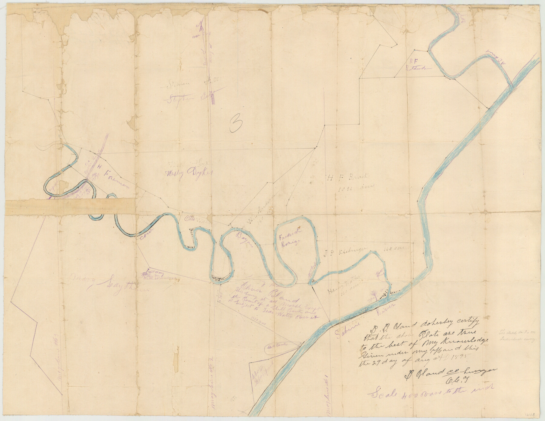
Orange County Sketch File 14
[Sketch of surveys around Cow Bayou and along the Sabine River]
-
Map/Doc
12118
-
Collection
General Map Collection
-
Object Dates
1895/8/31 (File Date)
-
People and Organizations
Joseph Bland (Surveyor/Engineer)
-
Counties
Orange
-
Subjects
Surveying Sketch File
-
Height x Width
19.9 x 32.9 inches
50.6 x 83.6 cm
-
Medium
paper, manuscript
-
Scale
1:400
-
Features
Cow Bayou
Part of: General Map Collection
Limestone County Working Sketch 26

Print $20.00
- Digital $50.00
Limestone County Working Sketch 26
1982
Size 39.6 x 44.1 inches
Map/Doc 70576
Cameron County Rolled Sketch 25

Print $20.00
- Digital $50.00
Cameron County Rolled Sketch 25
1977
Size 24.9 x 36.7 inches
Map/Doc 5799
Webb County Working Sketch 76

Print $20.00
- Digital $50.00
Webb County Working Sketch 76
1975
Size 43.3 x 37.5 inches
Map/Doc 72443
Refugio County Sketch File 7

Print $4.00
- Digital $50.00
Refugio County Sketch File 7
1875
Size 12.1 x 7.6 inches
Map/Doc 35251
Eastland County Working Sketch 60a

Print $20.00
- Digital $50.00
Eastland County Working Sketch 60a
1988
Size 45.1 x 39.0 inches
Map/Doc 78209

Sutton County Rolled Sketch 65

Print $20.00
- Digital $50.00
Sutton County Rolled Sketch 65
Size 40.8 x 30.5 inches
Map/Doc 7900
Crockett County Working Sketch 76

Print $20.00
- Digital $50.00
Crockett County Working Sketch 76
1964
Size 34.3 x 36.3 inches
Map/Doc 68409
Flight Mission No. DIX-10P, Frame 181, Aransas County

Print $20.00
- Digital $50.00
Flight Mission No. DIX-10P, Frame 181, Aransas County
1956
Size 18.5 x 22.2 inches
Map/Doc 83971
Newton County Sketch File 9

Print $4.00
- Digital $50.00
Newton County Sketch File 9
Size 9.8 x 8.3 inches
Map/Doc 32378
Presidio County Working Sketch 92

Print $20.00
- Digital $50.00
Presidio County Working Sketch 92
1976
Size 27.1 x 23.1 inches
Map/Doc 71769
Runnels County Sketch File 25

Print $20.00
Runnels County Sketch File 25
1940
Size 16.5 x 16.7 inches
Map/Doc 12259
You may also like
Newton County Sketch File 11

Print $4.00
- Digital $50.00
Newton County Sketch File 11
1876
Size 7.9 x 12.7 inches
Map/Doc 32380
Culberson County Working Sketch 60

Print $40.00
- Digital $50.00
Culberson County Working Sketch 60
1974
Size 74.7 x 32.7 inches
Map/Doc 68514
Crockett County Rolled Sketch 89

Print $20.00
- Digital $50.00
Crockett County Rolled Sketch 89
1974
Size 21.1 x 15.8 inches
Map/Doc 5630
Upton County Sketch File 21

Print $20.00
- Digital $50.00
Upton County Sketch File 21
1927
Size 15.0 x 23.7 inches
Map/Doc 12518
Wilson County Sketch File 7

Print $42.00
- Digital $50.00
Wilson County Sketch File 7
1885
Size 10.7 x 8.5 inches
Map/Doc 40410
Jackson County Working Sketch 4

Print $20.00
- Digital $50.00
Jackson County Working Sketch 4
1941
Size 34.1 x 28.5 inches
Map/Doc 66452
San Augustine County Working Sketch 4

Print $20.00
- Digital $50.00
San Augustine County Working Sketch 4
1934
Size 24.4 x 27.7 inches
Map/Doc 63691
Hunt County Sketch File 33

Print $4.00
- Digital $50.00
Hunt County Sketch File 33
1864
Size 7.1 x 5.0 inches
Map/Doc 27141
Live Oak County Rolled Sketch 8

Print $20.00
- Digital $50.00
Live Oak County Rolled Sketch 8
1969
Size 43.5 x 32.8 inches
Map/Doc 9455
Leon County Rolled Sketch 27A

Print $40.00
- Digital $50.00
Leon County Rolled Sketch 27A
Size 50.5 x 47.8 inches
Map/Doc 9437
Sterling County Rolled Sketch 26

Print $20.00
- Digital $50.00
Sterling County Rolled Sketch 26
1955
Size 23.8 x 21.4 inches
Map/Doc 7851
