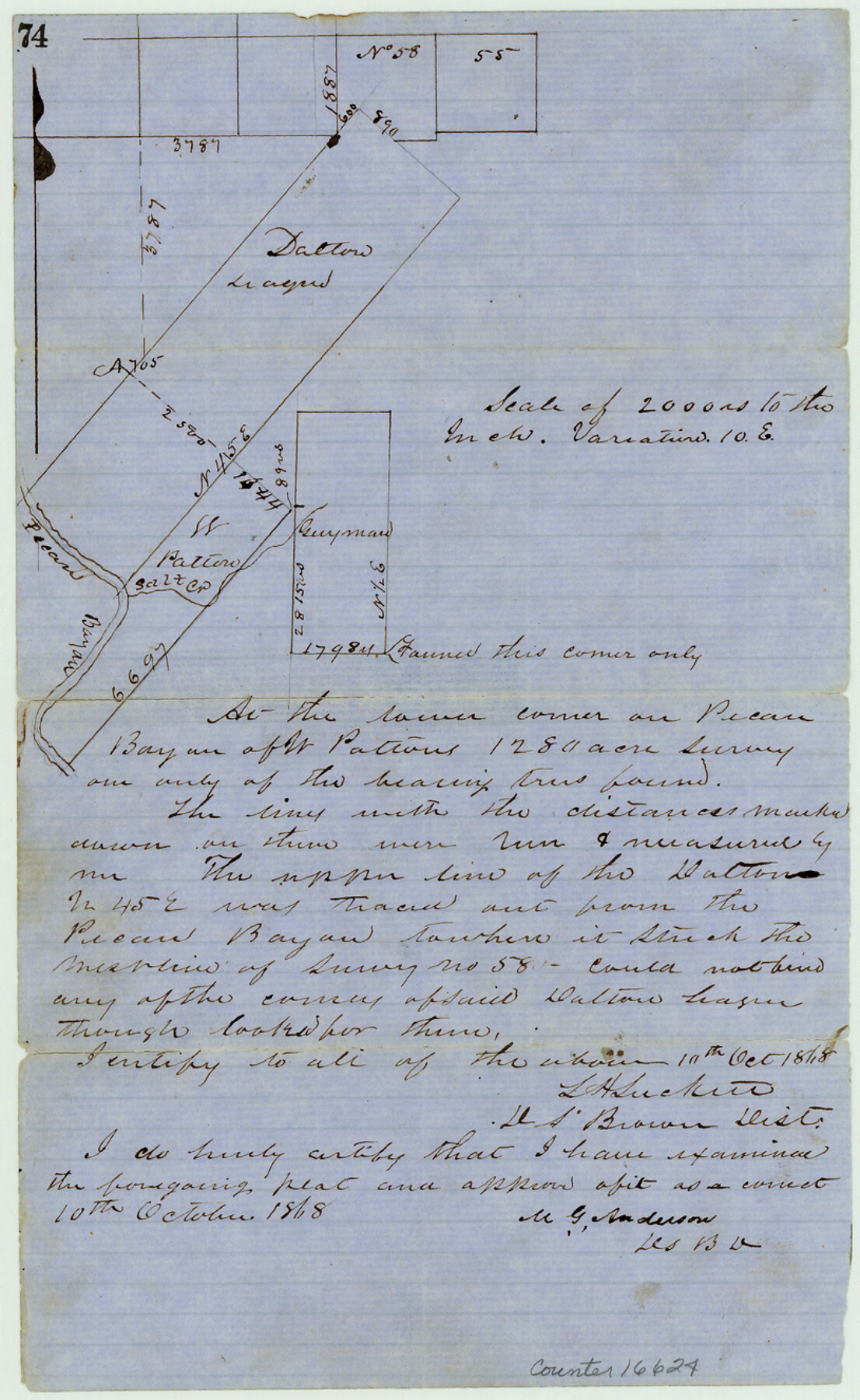
Brown County Sketch File 27
[Sketch and statement regarding William Patton and Osborn Dalton surveys]
-
Map/Doc
16624
-
Collection
General Map Collection
-
Object Dates
1868/10/10 (Creation Date)
-
People and Organizations
L.H. Luckett (Surveyor/Engineer)
-
Counties
Brown
-
Subjects
Surveying Sketch File
-
Height x Width
13.3 x 8.1 inches
33.8 x 20.6 cm
-
Medium
paper, manuscript
-
Scale
1" = 2000 varas
-
Features
Pecan Bayou
Part of: General Map Collection
Wheeler County

Print $20.00
- Digital $50.00
Wheeler County
1899
Size 44.2 x 38.7 inches
Map/Doc 63121
United States Gulf Coast - from Galveston to the Rio Grande

Print $20.00
- Digital $50.00
United States Gulf Coast - from Galveston to the Rio Grande
1915
Size 26.3 x 18.3 inches
Map/Doc 72731
Flight Mission No. DIX-8P, Frame 91, Aransas County

Print $20.00
- Digital $50.00
Flight Mission No. DIX-8P, Frame 91, Aransas County
1956
Size 18.5 x 22.4 inches
Map/Doc 83916
Nolan County Sketch File 13

Print $20.00
- Digital $50.00
Nolan County Sketch File 13
1886
Size 17.8 x 29.9 inches
Map/Doc 42207
Kinney County Rolled Sketch 2

Print $20.00
- Digital $50.00
Kinney County Rolled Sketch 2
Size 24.5 x 36.2 inches
Map/Doc 6534
Flight Mission No. CRK-3P, Frame 62, Refugio County

Print $20.00
- Digital $50.00
Flight Mission No. CRK-3P, Frame 62, Refugio County
1956
Size 18.6 x 22.6 inches
Map/Doc 86904
Foard County Rolled Sketch 11

Print $20.00
- Digital $50.00
Foard County Rolled Sketch 11
Size 29.2 x 35.6 inches
Map/Doc 5885
Map of Africa (Inset: Liberia and Sierra Leone)

Print $20.00
- Digital $50.00
Map of Africa (Inset: Liberia and Sierra Leone)
1844
Size 9.5 x 12.1 inches
Map/Doc 93549
Prison Property, Walker County

Print $20.00
- Digital $50.00
Prison Property, Walker County
Size 32.6 x 22.7 inches
Map/Doc 94279
Robertson County Sketch File 3

Print $22.00
- Digital $50.00
Robertson County Sketch File 3
1860
Size 12.6 x 15.8 inches
Map/Doc 35350
Current Miscellaneous File 67

Print $8.00
- Digital $50.00
Current Miscellaneous File 67
1957
Size 11.2 x 8.8 inches
Map/Doc 74130
[Missouri, Kansas & Texas Line Map through Bastrop County]
![64031, [Missouri, Kansas & Texas Line Map through Bastrop County], General Map Collection](https://historictexasmaps.com/wmedia_w700/maps/64031.tif.jpg)
Print $40.00
- Digital $50.00
[Missouri, Kansas & Texas Line Map through Bastrop County]
1916
Size 26.5 x 124.4 inches
Map/Doc 64031
You may also like
[Reverse of] Plan of the City of Austin
![76228, [Reverse of] Plan of the City of Austin, Texas State Library and Archives](https://historictexasmaps.com/wmedia_w700/maps/76228.tif.jpg)
Print $20.00
[Reverse of] Plan of the City of Austin
1839
Size 19.2 x 24.3 inches
Map/Doc 76228
Smith County Working Sketch 3

Print $20.00
- Digital $50.00
Smith County Working Sketch 3
Size 16.0 x 12.6 inches
Map/Doc 63888
Potter County Working Sketch 11

Print $20.00
- Digital $50.00
Potter County Working Sketch 11
1972
Size 27.4 x 26.4 inches
Map/Doc 71671
Sutton County Rolled Sketch F

Print $20.00
- Digital $50.00
Sutton County Rolled Sketch F
Size 12.7 x 38.9 inches
Map/Doc 7903
Cooke County Working Sketch 11

Print $20.00
- Digital $50.00
Cooke County Working Sketch 11
1940
Size 42.6 x 28.2 inches
Map/Doc 68248
Matagorda County Sketch File 15

Print $48.00
- Digital $50.00
Matagorda County Sketch File 15
Size 8.7 x 11.2 inches
Map/Doc 30774
Webb County Working Sketch 16

Print $20.00
- Digital $50.00
Webb County Working Sketch 16
1923
Size 27.6 x 32.1 inches
Map/Doc 72381
Cass County Working Sketch 54

Print $20.00
- Digital $50.00
Cass County Working Sketch 54
2012
Size 26.2 x 21.6 inches
Map/Doc 93337
Coleman County Working Sketch 9

Print $20.00
- Digital $50.00
Coleman County Working Sketch 9
1950
Size 24.9 x 30.5 inches
Map/Doc 68075
Tyler County Rolled Sketch 1

Print $20.00
- Digital $50.00
Tyler County Rolled Sketch 1
1941
Size 16.4 x 19.7 inches
Map/Doc 8055
Preliminary Chart of Entrance to Brazos River, Texas

Print $20.00
- Digital $50.00
Preliminary Chart of Entrance to Brazos River, Texas
Size 17.6 x 19.8 inches
Map/Doc 81986
[Blocks 34-36, Township 1N]
![92031, [Blocks 34-36, Township 1N], Twichell Survey Records](https://historictexasmaps.com/wmedia_w700/maps/92031-1.tif.jpg)
Print $20.00
- Digital $50.00
[Blocks 34-36, Township 1N]
Size 36.8 x 23.8 inches
Map/Doc 92031