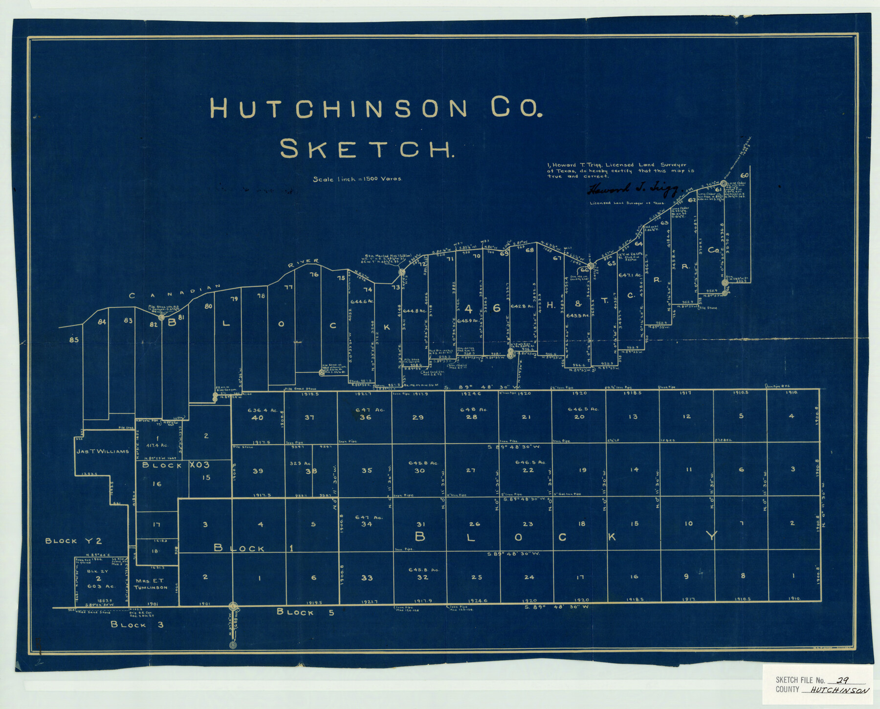
Hutchinson County Sketch File 29
Trigg's Sk. of Blks. 46, X03, 1, Y & Y2
-
Map/Doc
11818
-
Collection
General Map Collection
-
Object Dates
1/10/1927 (File Date)
-
People and Organizations
Howard T. Trigg (Surveyor/Engineer)
-
Counties
Hutchinson
-
Subjects
Surveying Sketch File
-
Height x Width
16.7 x 20.8 inches
42.4 x 52.8 cm
-
Medium
blueprint/diazo
-
Scale
1" = 1500 varas
-
Features
Canadian River
Part of: General Map Collection
Kinney County Working Sketch 14

Print $20.00
- Digital $50.00
Kinney County Working Sketch 14
1946
Size 20.8 x 28.5 inches
Map/Doc 70196
Motley County Sketch File 23 (S)

Print $2.00
- Digital $50.00
Motley County Sketch File 23 (S)
Size 4.2 x 8.4 inches
Map/Doc 32203
Cameron County Rolled Sketch 34

Print $20.00
- Digital $50.00
Cameron County Rolled Sketch 34
2000
Size 24.2 x 35.2 inches
Map/Doc 5397
Midland County Rolled Sketch 11

Print $20.00
- Digital $50.00
Midland County Rolled Sketch 11
Size 45.7 x 26.2 inches
Map/Doc 6767
Erath County Sketch File 3

Print $4.00
- Digital $50.00
Erath County Sketch File 3
1853
Size 13.0 x 8.3 inches
Map/Doc 22255
Floyd County Working Sketch 7

Print $20.00
- Digital $50.00
Floyd County Working Sketch 7
1922
Size 14.4 x 17.9 inches
Map/Doc 69186
Polk County Sketch File 10

Print $4.00
- Digital $50.00
Polk County Sketch File 10
Size 5.2 x 6.4 inches
Map/Doc 34140
Webb County Working Sketch 38

Print $20.00
- Digital $50.00
Webb County Working Sketch 38
1941
Size 20.0 x 17.8 inches
Map/Doc 72403
Hood County Working Sketch 15

Print $20.00
- Digital $50.00
Hood County Working Sketch 15
1985
Size 30.0 x 28.2 inches
Map/Doc 66209
Harbor Pass and Bar at Brazos Santiago, Texas

Print $20.00
- Digital $50.00
Harbor Pass and Bar at Brazos Santiago, Texas
1879
Size 18.1 x 27.4 inches
Map/Doc 73002
Coleman County Sketch File 3

Print $4.00
- Digital $50.00
Coleman County Sketch File 3
1857
Size 9.5 x 8.1 inches
Map/Doc 18670
Jim Wells County Working Sketch 13

Print $20.00
- Digital $50.00
Jim Wells County Working Sketch 13
1980
Size 36.7 x 26.3 inches
Map/Doc 66611
You may also like
Duval County Sketch File 43

Print $20.00
- Digital $50.00
Duval County Sketch File 43
Size 22.9 x 21.1 inches
Map/Doc 11398
Terry County Boundary File 4a

Print $70.00
- Digital $50.00
Terry County Boundary File 4a
Size 11.4 x 8.8 inches
Map/Doc 59249
[Right of Way & Track Map, The Texas & Pacific Ry. Co. Main Line]
![64688, [Right of Way & Track Map, The Texas & Pacific Ry. Co. Main Line], General Map Collection](https://historictexasmaps.com/wmedia_w700/maps/64688.tif.jpg)
Print $20.00
- Digital $50.00
[Right of Way & Track Map, The Texas & Pacific Ry. Co. Main Line]
Size 11.0 x 19.0 inches
Map/Doc 64688
[Yates survey 34 1/2 and vicinity]
![91689, [Yates survey 34 1/2 and vicinity], Twichell Survey Records](https://historictexasmaps.com/wmedia_w700/maps/91689-1.tif.jpg)
Print $20.00
- Digital $50.00
[Yates survey 34 1/2 and vicinity]
Size 12.6 x 17.8 inches
Map/Doc 91689
Carte du Mexique ou de la Nouvelle Espagne

Print $20.00
Carte du Mexique ou de la Nouvelle Espagne
1750
Size 12.4 x 15.5 inches
Map/Doc 79741

Flight Mission No. BQR-13K, Frame 120, Brazoria County

Print $20.00
- Digital $50.00
Flight Mission No. BQR-13K, Frame 120, Brazoria County
1952
Size 18.8 x 22.5 inches
Map/Doc 84081
Smith County Sketch File 7

Print $4.00
- Digital $50.00
Smith County Sketch File 7
1848
Size 12.7 x 8.2 inches
Map/Doc 36759
Flight Mission No. BQR-9K, Frame 5, Brazoria County

Print $20.00
- Digital $50.00
Flight Mission No. BQR-9K, Frame 5, Brazoria County
1952
Size 18.7 x 22.3 inches
Map/Doc 84034
Travis County Appraisal District Plat Map 2_0905

Print $20.00
- Digital $50.00
Travis County Appraisal District Plat Map 2_0905
Size 21.4 x 26.4 inches
Map/Doc 94232
Medina County

Print $40.00
- Digital $50.00
Medina County
1976
Size 53.5 x 44.2 inches
Map/Doc 95587
Flight Mission No. BQY-1T, Frame 74, Harris County

Print $20.00
- Digital $50.00
Flight Mission No. BQY-1T, Frame 74, Harris County
1957
Size 17.5 x 17.6 inches
Map/Doc 85294