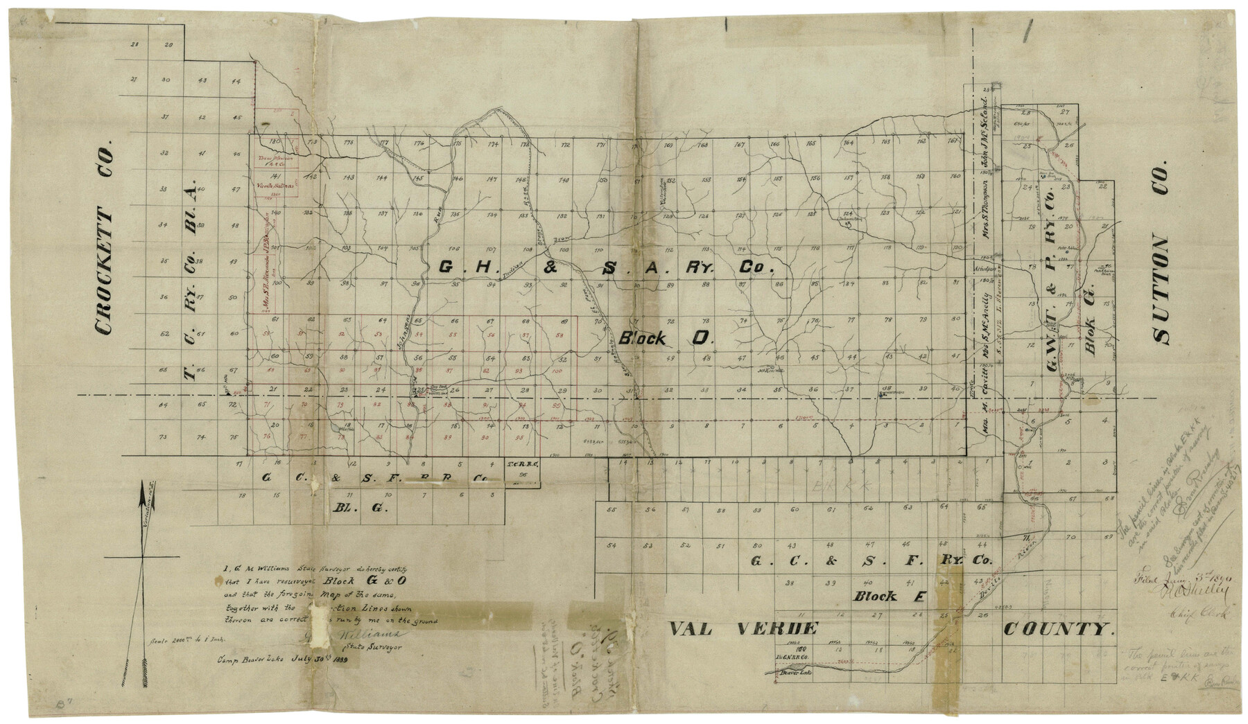
Crockett County Sketch File 39
Block "O" on line of Val Verde; Sutton & Crockett Cos.
-
Map/Doc
11221
-
Collection
General Map Collection
-
Object Dates
9/30/1889 (Creation Date)
1/3/1890 (File Date)
-
People and Organizations
G.M. Williams (Surveyor/Engineer)
R.C. Shelley (GLO Clerk)
-
Counties
Crockett Sutton Val Verde
-
Subjects
Surveying Sketch File
-
Height x Width
19.7 x 32.6 inches
50.0 x 82.8 cm
-
Medium
paper, manuscript
-
Scale
1:2000
-
Features
Jackson's Bank
Willow Bank Water Hole
Indian Draw
McKenzie Waterhole
San Antonio and El Paso Stage Road
San Antonio Stage Road
El Paso Stage Road
C.W. Whitehead's Waterhole
Clay Bank Waterhole
Devil's River
Beaver Lake
Related maps
Crockett County Sketch File F

Print $20.00
- Digital $50.00
Crockett County Sketch File F
1907
Size 26.3 x 15.7 inches
Map/Doc 11240
Sutton County Sketch File B

Print $20.00
- Digital $50.00
Sutton County Sketch File B
Size 17.1 x 22.2 inches
Map/Doc 12395
Part of: General Map Collection
Val Verde County Sketch File 42

Print $20.00
- Digital $50.00
Val Verde County Sketch File 42
1939
Size 19.4 x 20.3 inches
Map/Doc 12584
Young County Working Sketch 23

Print $20.00
- Digital $50.00
Young County Working Sketch 23
1965
Size 31.3 x 22.3 inches
Map/Doc 62046
Llano County Sketch File 19

Print $16.00
- Digital $50.00
Llano County Sketch File 19
1961
Size 14.2 x 8.7 inches
Map/Doc 30397
Ochiltree County Rolled Sketch 2

Print $20.00
- Digital $50.00
Ochiltree County Rolled Sketch 2
Size 23.0 x 17.7 inches
Map/Doc 7172
Dimmit County Rolled Sketch 21

Print $20.00
- Digital $50.00
Dimmit County Rolled Sketch 21
2013
Size 25.5 x 22.5 inches
Map/Doc 93488
Kent County Rolled Sketch 8

Print $20.00
- Digital $50.00
Kent County Rolled Sketch 8
1873
Size 31.5 x 35.5 inches
Map/Doc 9344
Flight Mission No. DAG-19K, Frame 66, Matagorda County

Print $20.00
- Digital $50.00
Flight Mission No. DAG-19K, Frame 66, Matagorda County
1952
Size 16.3 x 16.3 inches
Map/Doc 86393
Dickens County Sketch File 15

Print $4.00
- Digital $50.00
Dickens County Sketch File 15
Size 12.6 x 8.0 inches
Map/Doc 20973
[Surveys in Austin's Colony along the east bank of the Navidad River]
![78488, [Surveys in Austin's Colony along the east bank of the Navidad River], General Map Collection](https://historictexasmaps.com/wmedia_w700/maps/78488.tif.jpg)
Print $20.00
- Digital $50.00
[Surveys in Austin's Colony along the east bank of the Navidad River]
1827
Size 20.3 x 16.1 inches
Map/Doc 78488
Crosby County Working Sketch 18

Print $20.00
- Digital $50.00
Crosby County Working Sketch 18
1982
Size 22.7 x 31.0 inches
Map/Doc 68452
[Map of Matagorda County]
![3841, [Map of Matagorda County], General Map Collection](https://historictexasmaps.com/wmedia_w700/maps/3841.tif.jpg)
Print $20.00
- Digital $50.00
[Map of Matagorda County]
Size 24.4 x 25.6 inches
Map/Doc 3841
Pecos County Sketch File 76A

Print $20.00
- Digital $50.00
Pecos County Sketch File 76A
Size 16.1 x 18.3 inches
Map/Doc 12182
You may also like
Parmer County Working Sketch Graphic Index

Print $20.00
- Digital $50.00
Parmer County Working Sketch Graphic Index
1926
Map/Doc 76662
Flight Mission No. CUG-2P, Frame 25, Kleberg County

Print $20.00
- Digital $50.00
Flight Mission No. CUG-2P, Frame 25, Kleberg County
1956
Size 18.5 x 22.2 inches
Map/Doc 86189
[Victoria District]
![1945, [Victoria District], General Map Collection](https://historictexasmaps.com/wmedia_w700/maps/1945.tif.jpg)
Print $20.00
- Digital $50.00
[Victoria District]
Size 34.8 x 25.6 inches
Map/Doc 1945

Kenedy County Sketch File 3

Print $22.00
- Digital $50.00
Kenedy County Sketch File 3
2003
Size 11.0 x 8.5 inches
Map/Doc 82452
Liberty County Rolled Sketch O

Print $40.00
- Digital $50.00
Liberty County Rolled Sketch O
1954
Size 44.3 x 53.7 inches
Map/Doc 10183
Sketch of Surveys in Crosby and Garza Cos.

Print $20.00
- Digital $50.00
Sketch of Surveys in Crosby and Garza Cos.
Size 19.7 x 25.3 inches
Map/Doc 90338
Hockley County

Print $20.00
- Digital $50.00
Hockley County
1954
Size 44.2 x 39.7 inches
Map/Doc 95531
General Highway Map, Childress County, Texas

Print $20.00
General Highway Map, Childress County, Texas
1940
Size 18.3 x 25.2 inches
Map/Doc 79046
[Surveys in Burleson County]
![78355, [Surveys in Burleson County], General Map Collection](https://historictexasmaps.com/wmedia_w700/maps/78355.tif.jpg)
Print $20.00
- Digital $50.00
[Surveys in Burleson County]
Size 19.6 x 28.3 inches
Map/Doc 78355
Fractional Township No. 7 South Range No. 1 East of the Indian Meridian, Indian Territory

Print $20.00
- Digital $50.00
Fractional Township No. 7 South Range No. 1 East of the Indian Meridian, Indian Territory
1898
Size 19.2 x 24.6 inches
Map/Doc 75199
[Sketch showing Blocks B8, B15, 43, 44, 45]
![90925, [Sketch showing Blocks B8, B15, 43, 44, 45], Twichell Survey Records](https://historictexasmaps.com/wmedia_w700/maps/90925-1.tif.jpg)
Print $20.00
- Digital $50.00
[Sketch showing Blocks B8, B15, 43, 44, 45]
Size 46.7 x 22.7 inches
Map/Doc 90925