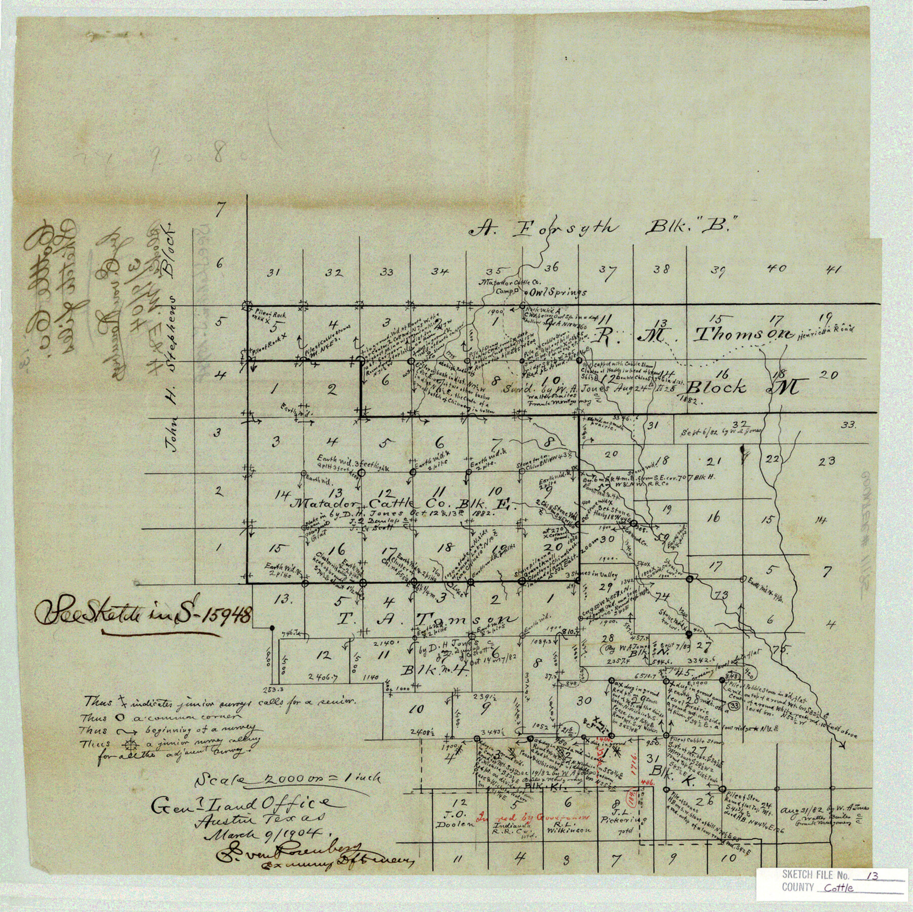
Cottle County Sketch File 13
[Office sketch of Matador Cattle Co. Block E and surrounding area north and east from Paducah]
-
Map/Doc
11195
-
Collection
General Map Collection
-
Object Dates
3/9/1904 (Creation Date)
-
People and Organizations
E. von Rosenberg (Draftsman)
-
Counties
Cottle
-
Subjects
Surveying Sketch File
-
Height x Width
15.8 x 15.8 inches
40.1 x 40.1 cm
-
Medium
paper, manuscript
-
Scale
1" = 2000 varas
-
Features
Owl Springs
Matador Cattle Co. Camp
Henrietta Road
Cottonwood Creek
Part of: General Map Collection
Ward County Rolled Sketch 9

Print $40.00
- Digital $50.00
Ward County Rolled Sketch 9
1936
Size 51.5 x 41.9 inches
Map/Doc 10105
Surveys in Reeves and Culberson Counties, Texas and Pacific Railroad Company, Blocks 58, 59, 60, and 61

Print $20.00
- Digital $50.00
Surveys in Reeves and Culberson Counties, Texas and Pacific Railroad Company, Blocks 58, 59, 60, and 61
1937
Size 30.7 x 25.3 inches
Map/Doc 2250
Map of Concho County

Print $20.00
- Digital $50.00
Map of Concho County
1897
Size 46.9 x 38.4 inches
Map/Doc 4919
Flight Mission No. BRE-2P, Frame 96, Nueces County

Print $20.00
- Digital $50.00
Flight Mission No. BRE-2P, Frame 96, Nueces County
1956
Size 18.4 x 22.3 inches
Map/Doc 86781
Montague County Sketch File 17

Print $40.00
- Digital $50.00
Montague County Sketch File 17
1893
Size 14.3 x 16.6 inches
Map/Doc 31744
Frio County Rolled Sketch 14

Print $20.00
- Digital $50.00
Frio County Rolled Sketch 14
1949
Size 25.3 x 32.9 inches
Map/Doc 5921
Flight Mission No. DCL-6C, Frame 92, Kenedy County

Print $20.00
- Digital $50.00
Flight Mission No. DCL-6C, Frame 92, Kenedy County
1943
Size 18.4 x 22.3 inches
Map/Doc 85922
Pecos County Working Sketch 65

Print $20.00
- Digital $50.00
Pecos County Working Sketch 65
1955
Size 25.0 x 19.4 inches
Map/Doc 71537
Webb County Sketch File 52

Print $40.00
- Digital $50.00
Webb County Sketch File 52
1939
Size 14.2 x 16.7 inches
Map/Doc 39839
Controlled Mosaic by Jack Amman Photogrammetric Engineers, Inc - Sheet 20

Print $20.00
- Digital $50.00
Controlled Mosaic by Jack Amman Photogrammetric Engineers, Inc - Sheet 20
1954
Size 20.0 x 24.0 inches
Map/Doc 83467
Angelina County Boundary File 2

Print $20.00
- Digital $50.00
Angelina County Boundary File 2
Size 10.2 x 28.2 inches
Map/Doc 49773
Hemphill County Working Sketch 1

Print $20.00
- Digital $50.00
Hemphill County Working Sketch 1
1926
Size 15.1 x 19.7 inches
Map/Doc 66096
You may also like
Kendall County Working Sketch 16

Print $20.00
- Digital $50.00
Kendall County Working Sketch 16
1967
Size 28.0 x 29.1 inches
Map/Doc 66688
Hidalgo County Sketch File 11

Print $40.00
- Digital $50.00
Hidalgo County Sketch File 11
1908
Size 18.5 x 13.6 inches
Map/Doc 26429
[Gulf, Colorado & Santa Fe]
![64591, [Gulf, Colorado & Santa Fe], General Map Collection](https://historictexasmaps.com/wmedia_w700/maps/64591.tif.jpg)
Print $40.00
- Digital $50.00
[Gulf, Colorado & Santa Fe]
1918
Size 63.1 x 31.2 inches
Map/Doc 64591
Flight Mission No. BRA-16M, Frame 62, Jefferson County

Print $20.00
- Digital $50.00
Flight Mission No. BRA-16M, Frame 62, Jefferson County
1953
Size 18.7 x 22.4 inches
Map/Doc 85679
City of Austin, Texas - Use District Map

Print $20.00
- Digital $50.00
City of Austin, Texas - Use District Map
1943
Size 38.9 x 25.7 inches
Map/Doc 95705
Brewster County Rolled Sketch 24C

Print $20.00
- Digital $50.00
Brewster County Rolled Sketch 24C
Size 17.5 x 20.8 inches
Map/Doc 5210
Flight Mission No. CRC-5R, Frame 17, Chambers County

Print $20.00
- Digital $50.00
Flight Mission No. CRC-5R, Frame 17, Chambers County
1956
Size 18.8 x 22.5 inches
Map/Doc 84939
Floyd County Working Sketch 11

Print $20.00
- Digital $50.00
Floyd County Working Sketch 11
1998
Size 23.0 x 34.1 inches
Map/Doc 69190
Refugio County Working Sketch 17

Print $20.00
- Digital $50.00
Refugio County Working Sketch 17
1980
Size 17.7 x 30.1 inches
Map/Doc 63526
Grayson County Sketch File 22

Print $4.00
- Digital $50.00
Grayson County Sketch File 22
1871
Size 10.4 x 8.4 inches
Map/Doc 24501
[Blocks GM, D2, D3, GP, and T]
![91503, [Blocks GM, D2, D3, GP, and T], Twichell Survey Records](https://historictexasmaps.com/wmedia_w700/maps/91503-1.tif.jpg)
Print $20.00
- Digital $50.00
[Blocks GM, D2, D3, GP, and T]
Size 32.8 x 15.9 inches
Map/Doc 91503
