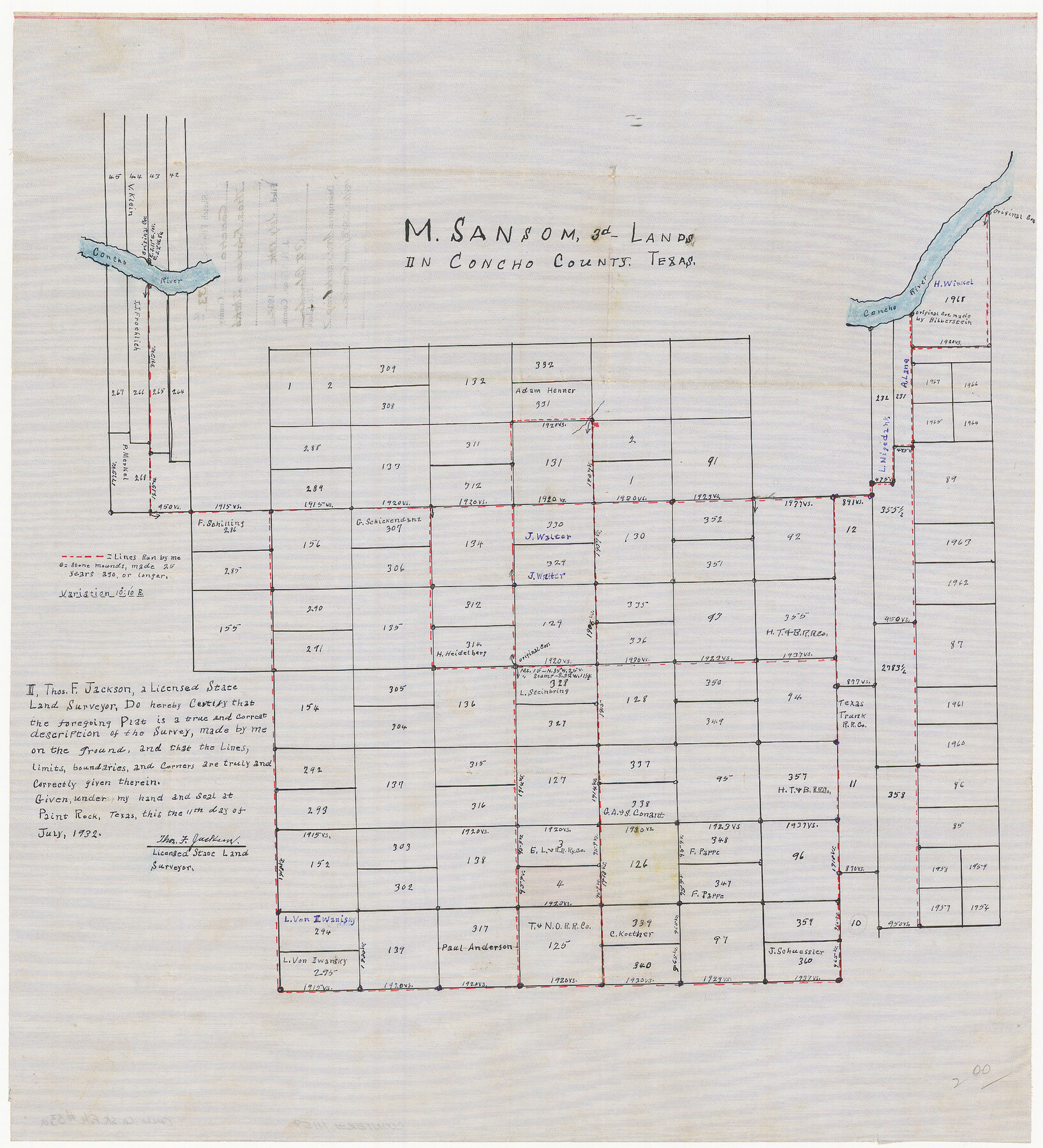
Concho County Sketch File 33a
[Letter regarding surveys southeast of Concho]
-
Map/Doc
11159
-
Collection
General Map Collection
-
Object Dates
7/13/1932 (File Date)
-
People and Organizations
Thomas F. Jackson (Surveyor/Engineer)
-
Counties
Concho
-
Subjects
Surveying Sketch File
-
Height x Width
21.4 x 19.4 inches
54.4 x 49.3 cm
-
Medium
paper, manuscript
-
Features
Concho River
Part of: General Map Collection
Lamar County Working Sketch 7

Print $20.00
- Digital $50.00
Lamar County Working Sketch 7
1964
Size 18.7 x 17.6 inches
Map/Doc 70268
Limestone County Sketch File 8

Print $20.00
- Digital $50.00
Limestone County Sketch File 8
1869
Size 15.6 x 23.7 inches
Map/Doc 12002
Terrell County Sketch File 25A

Print $20.00
- Digital $50.00
Terrell County Sketch File 25A
1890
Size 16.9 x 21.5 inches
Map/Doc 12424
Dickens County Working Sketch 11

Print $40.00
- Digital $50.00
Dickens County Working Sketch 11
1969
Size 52.6 x 37.8 inches
Map/Doc 68659
Upton County Working Sketch 9

Print $20.00
- Digital $50.00
Upton County Working Sketch 9
1926
Size 26.0 x 15.8 inches
Map/Doc 69505
Fisher County Rolled Sketch 7

Print $20.00
- Digital $50.00
Fisher County Rolled Sketch 7
1873
Size 47.1 x 43.5 inches
Map/Doc 8891
Crockett County Rolled Sketch JAS

Print $40.00
- Digital $50.00
Crockett County Rolled Sketch JAS
1938
Size 52.9 x 42.7 inches
Map/Doc 8699
La Salle County Working Sketch 17

Print $20.00
- Digital $50.00
La Salle County Working Sketch 17
1936
Size 16.7 x 19.9 inches
Map/Doc 70318
Armstrong County Sketch File A-15

Print $40.00
- Digital $50.00
Armstrong County Sketch File A-15
Size 17.8 x 14.0 inches
Map/Doc 13716
Ward County Working Sketch 26

Print $20.00
- Digital $50.00
Ward County Working Sketch 26
1964
Size 38.2 x 24.5 inches
Map/Doc 72332
Hutchinson County Working Sketch 16

Print $20.00
- Digital $50.00
Hutchinson County Working Sketch 16
1953
Size 23.0 x 36.3 inches
Map/Doc 66374
Parker County Working Sketch 15

Print $20.00
- Digital $50.00
Parker County Working Sketch 15
1982
Map/Doc 71465
You may also like
Flight Mission No. CRK-8P, Frame 116, Refugio County

Print $20.00
- Digital $50.00
Flight Mission No. CRK-8P, Frame 116, Refugio County
1956
Size 18.3 x 22.1 inches
Map/Doc 86971
[Blocks W, A4, A2, T, D10, B, JD, O, JK4]
![92251, [Blocks W, A4, A2, T, D10, B, JD, O, JK4], Twichell Survey Records](https://historictexasmaps.com/wmedia_w700/maps/92251-1.tif.jpg)
Print $20.00
- Digital $50.00
[Blocks W, A4, A2, T, D10, B, JD, O, JK4]
Size 36.9 x 30.1 inches
Map/Doc 92251
Current Miscellaneous File 28

Print $22.00
- Digital $50.00
Current Miscellaneous File 28
1952
Size 10.7 x 16.3 inches
Map/Doc 73911
Hartley County Rolled Sketch 7

Print $20.00
- Digital $50.00
Hartley County Rolled Sketch 7
1952
Size 24.2 x 27.4 inches
Map/Doc 6161
Galveston County Sketch File 8a

Print $6.00
- Digital $50.00
Galveston County Sketch File 8a
1861
Size 12.1 x 11.8 inches
Map/Doc 23367
J. De Cordova's Map of the State of Texas Compiled from the records of the General Land Office of the State

Print $20.00
J. De Cordova's Map of the State of Texas Compiled from the records of the General Land Office of the State
1851
Size 35.1 x 33.0 inches
Map/Doc 76223
Schleicher County Sketch File 29

Print $44.00
- Digital $50.00
Schleicher County Sketch File 29
1940
Size 31.9 x 23.7 inches
Map/Doc 12306
Fort Bend County Working Sketch 27

Print $20.00
- Digital $50.00
Fort Bend County Working Sketch 27
1982
Size 17.2 x 19.2 inches
Map/Doc 69233
[County School Lands]
![91109, [County School Lands], Twichell Survey Records](https://historictexasmaps.com/wmedia_w700/maps/91109-1.tif.jpg)
Print $20.00
- Digital $50.00
[County School Lands]
Size 18.6 x 13.6 inches
Map/Doc 91109
Brewster County Rolled Sketch 148B

Print $20.00
- Digital $50.00
Brewster County Rolled Sketch 148B
1994
Size 28.0 x 36.3 inches
Map/Doc 5315
Tyler County Rolled Sketch 10

Print $40.00
- Digital $50.00
Tyler County Rolled Sketch 10
1982
Size 48.7 x 35.4 inches
Map/Doc 10032
Presidio County Rolled Sketch 120

Print $49.00
- Digital $50.00
Presidio County Rolled Sketch 120
Size 9.9 x 15.0 inches
Map/Doc 48816