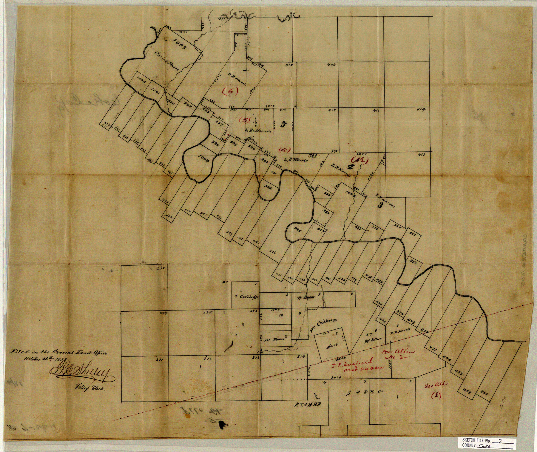
Coke County Sketch File 7
[Sketch of large area in the west part of Coke County]
-
Map/Doc
11105
-
Collection
General Map Collection
-
Object Dates
1888/10/26 (File Date)
-
Counties
Coke
-
Subjects
Surveying Sketch File
-
Height x Width
18.9 x 22.4 inches
48.0 x 56.9 cm
-
Medium
paper, manuscript
Part of: General Map Collection
Nolan County Sketch File 10

Print $6.00
- Digital $50.00
Nolan County Sketch File 10
1902
Size 14.2 x 9.0 inches
Map/Doc 32484
Burnet County Boundary File 7a

Print $30.00
- Digital $50.00
Burnet County Boundary File 7a
Size 14.1 x 8.5 inches
Map/Doc 50902
Freestone County Rolled Sketch 11

Print $20.00
- Digital $50.00
Freestone County Rolled Sketch 11
1934
Size 17.9 x 34.1 inches
Map/Doc 5911
Austin Map and Street Guide [Recto]
![94162, Austin Map and Street Guide [Recto], General Map Collection](https://historictexasmaps.com/wmedia_w700/maps/94162.tif.jpg)
Austin Map and Street Guide [Recto]
1976
Size 35.4 x 22.7 inches
Map/Doc 94162

Tyler County Sketch File 22

Print $4.00
- Digital $50.00
Tyler County Sketch File 22
Size 8.5 x 9.3 inches
Map/Doc 38679
University Land Field Notes for Blocks 19 and 20 in Pecos County

University Land Field Notes for Blocks 19 and 20 in Pecos County
Map/Doc 81724
Edwards County Rolled Sketch O

Print $20.00
- Digital $50.00
Edwards County Rolled Sketch O
Size 13.6 x 18.3 inches
Map/Doc 5820
Knox County Working Sketch 11

Print $20.00
- Digital $50.00
Knox County Working Sketch 11
1950
Size 16.8 x 29.0 inches
Map/Doc 70253

New Map of Texas with the Contiguous American and Mexican States

Print $20.00
- Digital $50.00
New Map of Texas with the Contiguous American and Mexican States
1836
Size 13.7 x 19.7 inches
Map/Doc 76795
Palo Pinto County Sketch File A

Print $6.00
- Digital $50.00
Palo Pinto County Sketch File A
Size 8.7 x 4.1 inches
Map/Doc 33389
You may also like
The Mexican Company Empresario Colony. May 1, 1832

Print $20.00
The Mexican Company Empresario Colony. May 1, 1832
2020
Size 15.0 x 21.7 inches
Map/Doc 95999
Crane County Sketch File 17

Print $6.00
- Digital $50.00
Crane County Sketch File 17
1927
Size 11.1 x 8.4 inches
Map/Doc 19581
Brazoria County Rolled Sketch 46

Print $40.00
- Digital $50.00
Brazoria County Rolled Sketch 46
1950
Size 30.7 x 57.3 inches
Map/Doc 8462

Map of Dimmit County

Print $20.00
- Digital $50.00
Map of Dimmit County
1875
Size 21.9 x 24.0 inches
Map/Doc 3489
1883 Map of the Texas & Pacific R-Y Reserve

Print $40.00
- Digital $50.00
1883 Map of the Texas & Pacific R-Y Reserve
1883
Size 42.2 x 86.4 inches
Map/Doc 2236
Hemphill County Rolled Sketch 17

Print $20.00
- Digital $50.00
Hemphill County Rolled Sketch 17
1965
Size 29.2 x 40.1 inches
Map/Doc 6198
Flight Mission No. BQY-4M, Frame 64, Harris County

Print $20.00
- Digital $50.00
Flight Mission No. BQY-4M, Frame 64, Harris County
1953
Size 18.6 x 22.5 inches
Map/Doc 85273
Rusk County Working Sketch 36

Print $20.00
- Digital $50.00
Rusk County Working Sketch 36
2007
Size 31.7 x 36.0 inches
Map/Doc 83786
Briscoe County Sketch File 8

Print $6.00
- Digital $50.00
Briscoe County Sketch File 8
1896
Size 10.5 x 8.3 inches
Map/Doc 16417
[T. & N. O. R.R. Jefferson Co. North]
![64055, [T. & N. O. R.R. Jefferson Co. North], General Map Collection](https://historictexasmaps.com/wmedia_w700/maps/64055.tif.jpg)
Print $20.00
- Digital $50.00
[T. & N. O. R.R. Jefferson Co. North]
Size 13.4 x 33.4 inches
Map/Doc 64055
Leon River, Leon River Sheet No. 1

Print $4.00
- Digital $50.00
Leon River, Leon River Sheet No. 1
1936
Size 29.2 x 19.8 inches
Map/Doc 65067