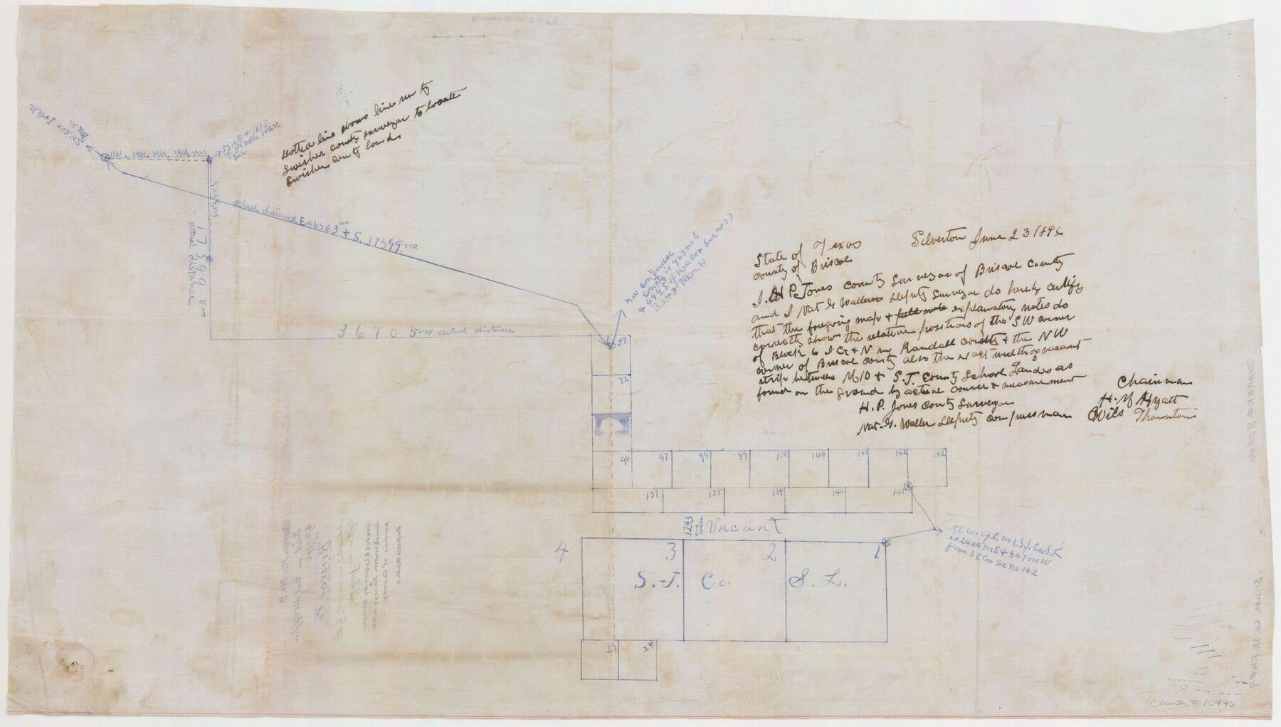
Briscoe County Sketch File 9
[Sketch and correspondence regarding surveys in northwest corner of county]
-
Map/Doc
10996
-
Collection
General Map Collection
-
Object Dates
1896/6/23 (Creation Date)
1896/6/27 (File Date)
-
People and Organizations
Nat G. Waller (Surveyor/Engineer)
H.P. Jones (Surveyor/Engineer)
-
Counties
Briscoe Randall Swisher
-
Subjects
Surveying Sketch File
-
Height x Width
31.9 x 27.2 inches
81.0 x 69.1 cm
-
Medium
paper, manuscript
-
Comments
See Briscoe County Sketch File 8 (16417) for statement.
Related maps
Briscoe County Sketch File 8

Print $6.00
- Digital $50.00
Briscoe County Sketch File 8
1896
Size 10.5 x 8.3 inches
Map/Doc 16417
Part of: General Map Collection
Gregg County Rolled Sketch 9A

Print $20.00
- Digital $50.00
Gregg County Rolled Sketch 9A
1932
Size 38.1 x 30.2 inches
Map/Doc 6035
[St. L. S-W. Ry. Of Texas Map of Lufkin Branch in Cherokee County Texas]
![64021, [St. L. S-W. Ry. Of Texas Map of Lufkin Branch in Cherokee County Texas], General Map Collection](https://historictexasmaps.com/wmedia_w700/maps/64021.tif.jpg)
Print $40.00
- Digital $50.00
[St. L. S-W. Ry. Of Texas Map of Lufkin Branch in Cherokee County Texas]
1912
Size 23.4 x 124.3 inches
Map/Doc 64021
Flight Mission No. BQR-13K, Frame 27, Brazoria County

Print $20.00
- Digital $50.00
Flight Mission No. BQR-13K, Frame 27, Brazoria County
1952
Size 18.7 x 22.5 inches
Map/Doc 84075
Travis County Sketch File 12

Print $4.00
- Digital $50.00
Travis County Sketch File 12
1850
Size 12.7 x 8.2 inches
Map/Doc 38304
Travis County Sketch File 24

Print $4.00
- Digital $50.00
Travis County Sketch File 24
1876
Size 8.1 x 15.4 inches
Map/Doc 38332
Trinity County Sketch File 4

Print $24.00
- Digital $50.00
Trinity County Sketch File 4
1858
Size 8.4 x 7.7 inches
Map/Doc 38501
Brewster County Rolled Sketch 127

Print $20.00
- Digital $50.00
Brewster County Rolled Sketch 127
1969
Size 39.0 x 43.8 inches
Map/Doc 8521
United States - Gulf Coast - From Latitude 26° 33' to the Rio Grande Texas

Print $20.00
- Digital $50.00
United States - Gulf Coast - From Latitude 26° 33' to the Rio Grande Texas
1919
Size 27.5 x 18.3 inches
Map/Doc 72855
Map of Johnson County & Hood County

Print $20.00
- Digital $50.00
Map of Johnson County & Hood County
1863
Size 19.3 x 28.3 inches
Map/Doc 3735
Kinney County Sketch File A1

Print $38.00
- Digital $50.00
Kinney County Sketch File A1
1905
Size 35.4 x 27.6 inches
Map/Doc 11952
[Surveys near Lake Soda made under G.W. Smyth, Commissioner]
![73, [Surveys near Lake Soda made under G.W. Smyth, Commissioner], General Map Collection](https://historictexasmaps.com/wmedia_w700/maps/73.tif.jpg)
Print $20.00
- Digital $50.00
[Surveys near Lake Soda made under G.W. Smyth, Commissioner]
1835
Size 16.0 x 19.3 inches
Map/Doc 73
Flight Mission No. BRE-1P, Frame 81, Nueces County

Print $20.00
- Digital $50.00
Flight Mission No. BRE-1P, Frame 81, Nueces County
1956
Size 18.3 x 22.1 inches
Map/Doc 86663
You may also like
Map Showing North and West Boundaries of Gray County, Texas

Print $20.00
- Digital $50.00
Map Showing North and West Boundaries of Gray County, Texas
1906
Size 42.4 x 38.9 inches
Map/Doc 89942
South Sulphur River, Klondike Sheet

Print $6.00
- Digital $50.00
South Sulphur River, Klondike Sheet
1925
Size 32.2 x 35.5 inches
Map/Doc 65170
Hardeman County Aerial Photograph Index Sheet 1

Print $20.00
- Digital $50.00
Hardeman County Aerial Photograph Index Sheet 1
1950
Size 19.8 x 17.0 inches
Map/Doc 83697
Falls of St. Anthony

Print $2.00
- Digital $50.00
Falls of St. Anthony
1810
Size 6.2 x 8.8 inches
Map/Doc 95152
Washington County Sketch File 6

Print $20.00
- Digital $50.00
Washington County Sketch File 6
1901
Size 24.7 x 26.0 inches
Map/Doc 12602
Newton County Rolled Sketch 25

Print $20.00
- Digital $50.00
Newton County Rolled Sketch 25
1893
Size 17.1 x 21.4 inches
Map/Doc 6854

In the Supreme Court of the United States, The State of Oklahoma, Complainant vs. The State of Texas, Defendant, The United States of America, Intervener, Red River Valley, Texas and Oklahoma Between the 98th and 100th Meridians in Five Sheets, 1921

Print $40.00
- Digital $50.00
In the Supreme Court of the United States, The State of Oklahoma, Complainant vs. The State of Texas, Defendant, The United States of America, Intervener, Red River Valley, Texas and Oklahoma Between the 98th and 100th Meridians in Five Sheets, 1921
1921
Size 37.2 x 59.5 inches
Map/Doc 75274
Bowie County Working Sketch 16

Print $20.00
- Digital $50.00
Bowie County Working Sketch 16
1961
Size 17.8 x 17.2 inches
Map/Doc 67420
Kerr County Working Sketch 22

Print $40.00
- Digital $50.00
Kerr County Working Sketch 22
1965
Size 50.9 x 40.4 inches
Map/Doc 70053
Harris County Sketch File 65

Print $20.00
- Digital $50.00
Harris County Sketch File 65
Size 23.5 x 35.1 inches
Map/Doc 11660
Galveston County Working Sketch 5

Print $20.00
- Digital $50.00
Galveston County Working Sketch 5
1934
Size 41.2 x 41.0 inches
Map/Doc 69342