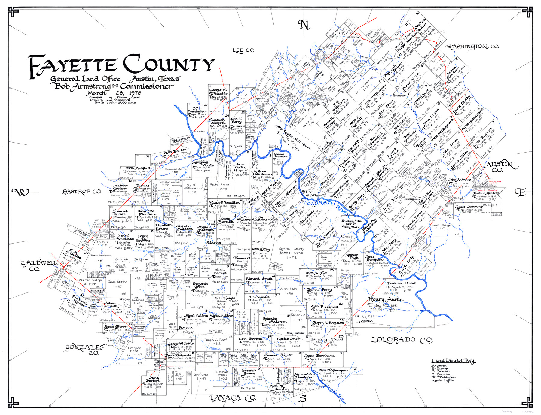
Fayette County
-
Map/Doc
73146
-
Collection
General Map Collection
-
Object Dates
3/28/1978 (Creation Date)
-
People and Organizations
Elbert Menzel (Compiler)
Bob Armstrong (GLO Commissioner)
Joan Kilpatrick (Draftsman)
-
Counties
Fayette
-
Subjects
County
-
Height x Width
42.5 x 54.7 inches
108.0 x 138.9 cm
-
Scale
1" = 2000 varas
-
Features
Peach Creek
South Fork of Buckner's Creek
Buckner's Creek
Lena
Muldoon
Burnham's Crossing
Harvey's Creek
Boggy Creek
Weimar
Schulenburg
GH&SA
Upper Rocky Creek
Sandy Fork of Mulberry Creek
Mulberry Creek
Flatonia
North Fork of Buckner's Creek
East Fork of Peach Creek
San Felipe Road
St. Barnabas Creek
Persimmon Creek
Fayetteville
William's Creek
Floy
Navidad River
Main Fork of Navidad River
Brushy Creek
East Navidad River
Gonzales Road
Wilbarger Trace
Williamson's Creek
Mesquite Creek
Pin Oak Creek
Little Pin Oak Creek
Ruiz Creek
Willow Creek
Rabb's Creek
David's Creek
Green's Creek
Owl Creek
Wilbarger Road
Washington Road
Bastrop Road
Washington to Bastrop Road
Cummins Creek
Pin Oak Fork of Buckner's Creek
Ledbetter
H&TC
Round Top
Rocky Creek
La Bahia Road
Cedar Creek
Miller's Creek
La Grange
Colorado River
SA&AP
Winchester
Westpoint
MK&T
Part of: General Map Collection
La Salle County Rolled Sketch 10

Print $40.00
- Digital $50.00
La Salle County Rolled Sketch 10
1945
Size 48.1 x 33.5 inches
Map/Doc 6573
No. 2 Chart of Corpus Christi Pass, Texas

Print $20.00
- Digital $50.00
No. 2 Chart of Corpus Christi Pass, Texas
1878
Size 18.3 x 27.4 inches
Map/Doc 73018
Flight Mission No. DQO-8K, Frame 50, Galveston County

Print $20.00
- Digital $50.00
Flight Mission No. DQO-8K, Frame 50, Galveston County
1952
Size 18.7 x 22.4 inches
Map/Doc 85157
Harris County NRC Article 33.136 Sketch 6

Print $21.00
- Digital $50.00
Harris County NRC Article 33.136 Sketch 6
2003
Size 23.1 x 34.8 inches
Map/Doc 78664
Galveston County NRC Article 33.136 Sketch 13

Print $20.00
- Digital $50.00
Galveston County NRC Article 33.136 Sketch 13
2002
Size 17.9 x 22.4 inches
Map/Doc 77044
Presidio County Rolled Sketch 131A

Print $40.00
- Digital $50.00
Presidio County Rolled Sketch 131A
1991
Size 37.6 x 49.7 inches
Map/Doc 10713
Panola County Working Sketch 33

Print $40.00
- Digital $50.00
Panola County Working Sketch 33
1983
Map/Doc 71442
Flight Mission No. BQR-20K, Frame 4, Brazoria County

Print $20.00
- Digital $50.00
Flight Mission No. BQR-20K, Frame 4, Brazoria County
1952
Size 18.8 x 22.4 inches
Map/Doc 84106
Stonewall County Sketch File 30

Print $120.00
- Digital $50.00
Stonewall County Sketch File 30
1986
Size 24.5 x 35.3 inches
Map/Doc 12370
Flight Mission No. DQO-11K, Frame 26, Galveston County

Print $20.00
- Digital $50.00
Flight Mission No. DQO-11K, Frame 26, Galveston County
1952
Size 18.8 x 22.5 inches
Map/Doc 85223
Presidio County Working Sketch 143

Print $20.00
- Digital $50.00
Presidio County Working Sketch 143
1990
Size 15.9 x 20.9 inches
Map/Doc 71821
Crockett County Sketch File 53

Print $10.00
- Digital $50.00
Crockett County Sketch File 53
1903
Size 11.4 x 8.9 inches
Map/Doc 19819
You may also like
Hopkins County Sketch File 19

Print $4.00
- Digital $50.00
Hopkins County Sketch File 19
1870
Size 10.2 x 8.0 inches
Map/Doc 26723
Map of Shelby County

Print $20.00
- Digital $50.00
Map of Shelby County
1839
Size 24.5 x 25.7 inches
Map/Doc 4032
Map of Copano, St. Charles, Aransas & Red Fish Bays in Aransas & Nueces Counties showing subdivision thereof for mineral development

Print $40.00
- Digital $50.00
Map of Copano, St. Charles, Aransas & Red Fish Bays in Aransas & Nueces Counties showing subdivision thereof for mineral development
Size 57.9 x 42.7 inches
Map/Doc 65805
Panola County Sketch File 13

Print $4.00
- Digital $50.00
Panola County Sketch File 13
1850
Size 14.1 x 7.8 inches
Map/Doc 33470
Oldham County Boundary File 2

Print $10.00
- Digital $50.00
Oldham County Boundary File 2
Size 14.2 x 8.6 inches
Map/Doc 57766
[Leagues 486-494, 503-539]
![93099, [Leagues 486-494, 503-539], Twichell Survey Records](https://historictexasmaps.com/wmedia_w700/maps/93099-1.tif.jpg)
Print $20.00
- Digital $50.00
[Leagues 486-494, 503-539]
Size 31.8 x 19.9 inches
Map/Doc 93099
Johnson County Sketch File 23

Print $22.00
- Digital $50.00
Johnson County Sketch File 23
1857
Size 8.1 x 12.6 inches
Map/Doc 28456
Atascosa County Sketch File 3c

Print $4.00
- Digital $50.00
Atascosa County Sketch File 3c
1858
Size 14.3 x 7.3 inches
Map/Doc 13743
Duval County Rolled Sketch 36

Print $20.00
- Digital $50.00
Duval County Rolled Sketch 36
1952
Size 27.7 x 21.9 inches
Map/Doc 5751
Flight Mission No. DQN-7K, Frame 95, Calhoun County

Print $20.00
- Digital $50.00
Flight Mission No. DQN-7K, Frame 95, Calhoun County
1953
Size 18.6 x 22.1 inches
Map/Doc 84486
Map of Colorado County

Print $20.00
- Digital $50.00
Map of Colorado County
1864
Size 22.1 x 25.0 inches
Map/Doc 3423
Flight Mission No. DQN-1K, Frame 79, Calhoun County

Print $20.00
- Digital $50.00
Flight Mission No. DQN-1K, Frame 79, Calhoun County
1953
Size 18.5 x 22.2 inches
Map/Doc 84164