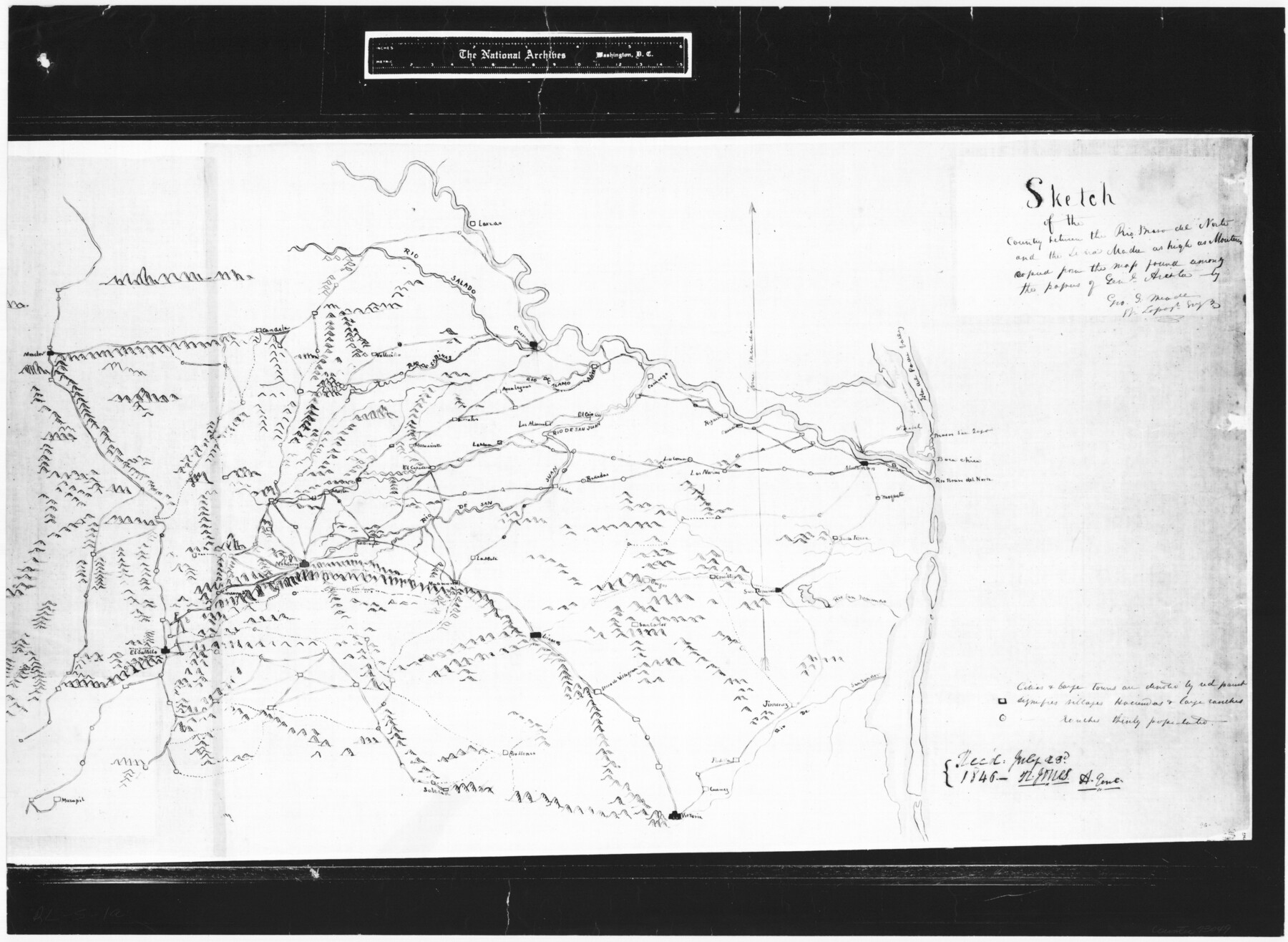
Sketch of the country between the Rio Bravo del Norte and the Luna Madre as high as Monterey copied from the map found among the papers of Genl. Arista
RL-5-1a
-
Map/Doc
73049
-
Collection
General Map Collection
-
Object Dates
1846 (Creation Date)
-
People and Organizations
George G. Meade (Draftsman)
-
Subjects
Military
-
Height x Width
18.2 x 24.9 inches
46.2 x 63.2 cm
-
Comments
B/W photostat copy from National Archives in multiple pieces.
Part of: General Map Collection
Surveys made on La Parita, March 1847

Print $2.00
- Digital $50.00
Surveys made on La Parita, March 1847
1847
Size 10.1 x 7.5 inches
Map/Doc 222
Calhoun County Rolled Sketch 22

Print $20.00
- Digital $50.00
Calhoun County Rolled Sketch 22
Size 35.0 x 37.0 inches
Map/Doc 8552
Johnson County Sketch File 4

Print $10.00
- Digital $50.00
Johnson County Sketch File 4
1858
Size 7.9 x 7.6 inches
Map/Doc 28435
Llano County Boundary File 1a

Print $44.00
- Digital $50.00
Llano County Boundary File 1a
Size 13.2 x 8.1 inches
Map/Doc 56430
Coke County Sketch File 25

Print $34.00
- Digital $50.00
Coke County Sketch File 25
1930
Size 14.2 x 8.9 inches
Map/Doc 18618
[Index map of T. & P. Ry. Company’s 80-mile Trans-Pecos Reserve’s perpetuated corners - South Part]
![69766, [Index map of T. & P. Ry. Company’s 80-mile Trans-Pecos Reserve’s perpetuated corners - South Part], General Map Collection](https://historictexasmaps.com/wmedia_w700/maps/69766.tif.jpg)
Print $40.00
- Digital $50.00
[Index map of T. & P. Ry. Company’s 80-mile Trans-Pecos Reserve’s perpetuated corners - South Part]
Size 23.1 x 90.1 inches
Map/Doc 69766
San Patricio County Sketch File 33

Print $20.00
- Digital $50.00
San Patricio County Sketch File 33
1946
Size 15.5 x 31.0 inches
Map/Doc 12288
Map of the River Sabine from its mouth on the Gulf of Mexico in the Sea to Logan's Ferry in Latitude 31°58'24" North

Print $20.00
- Digital $50.00
Map of the River Sabine from its mouth on the Gulf of Mexico in the Sea to Logan's Ferry in Latitude 31°58'24" North
1842
Size 47.9 x 30.6 inches
Map/Doc 87150
Schleicher County Sketch File 42

Print $40.00
- Digital $50.00
Schleicher County Sketch File 42
1963
Size 16.3 x 14.4 inches
Map/Doc 36546
Burleson County

Print $20.00
- Digital $50.00
Burleson County
1884
Size 21.9 x 25.2 inches
Map/Doc 3349
Flight Mission No. DIX-5P, Frame 103, Aransas County

Print $20.00
- Digital $50.00
Flight Mission No. DIX-5P, Frame 103, Aransas County
1956
Size 17.5 x 18.2 inches
Map/Doc 83781

You may also like
La Salle County

Print $40.00
- Digital $50.00
La Salle County
1923
Size 48.5 x 43.5 inches
Map/Doc 95562
Bastrop County Sketch File 11

Print $52.00
- Digital $50.00
Bastrop County Sketch File 11
Size 11.2 x 8.7 inches
Map/Doc 14058
Marion County Rolled Sketch 10

Print $20.00
- Digital $50.00
Marion County Rolled Sketch 10
2023
Size 24.1 x 36.9 inches
Map/Doc 97192
Cameron County NRC Article 33.136 Sketch 5

Print $202.00
- Digital $50.00
Cameron County NRC Article 33.136 Sketch 5
2018
Size 24.3 x 36.1 inches
Map/Doc 95724
Mason County Working Sketch 7

Print $20.00
- Digital $50.00
Mason County Working Sketch 7
1945
Size 35.8 x 43.9 inches
Map/Doc 70843
Neel's Creek of North Bosque

Print $2.00
- Digital $50.00
Neel's Creek of North Bosque
1847
Size 8.9 x 7.9 inches
Map/Doc 69755
Flight Mission No. DIX-10P, Frame 184, Aransas County

Print $20.00
- Digital $50.00
Flight Mission No. DIX-10P, Frame 184, Aransas County
1956
Size 18.5 x 22.2 inches
Map/Doc 83974
Jefferson County Rolled Sketch 27

Print $20.00
- Digital $50.00
Jefferson County Rolled Sketch 27
1948
Size 24.2 x 46.6 inches
Map/Doc 9292
Portion of Lands in Parmer County, Texas Owned and For Sale by Capitol Freehold Land and Investment Co., Ltd.

Print $3.00
- Digital $50.00
Portion of Lands in Parmer County, Texas Owned and For Sale by Capitol Freehold Land and Investment Co., Ltd.
Size 16.7 x 11.3 inches
Map/Doc 91550
P. W. Walker Seed and Grain Co. Littlefield, Texas

Print $20.00
- Digital $50.00
P. W. Walker Seed and Grain Co. Littlefield, Texas
1950
Size 36.9 x 15.8 inches
Map/Doc 92404
Maps & Lists Showing Prison Lands (Oil & Gas) Leased as of June 1955

Digital $50.00
Maps & Lists Showing Prison Lands (Oil & Gas) Leased as of June 1955
Size 8.9 x 11.3 inches
Map/Doc 62870
Nueces County Rolled Sketch 47

Print $20.00
- Digital $50.00
Nueces County Rolled Sketch 47
1953
Size 31.3 x 44.6 inches
Map/Doc 6886