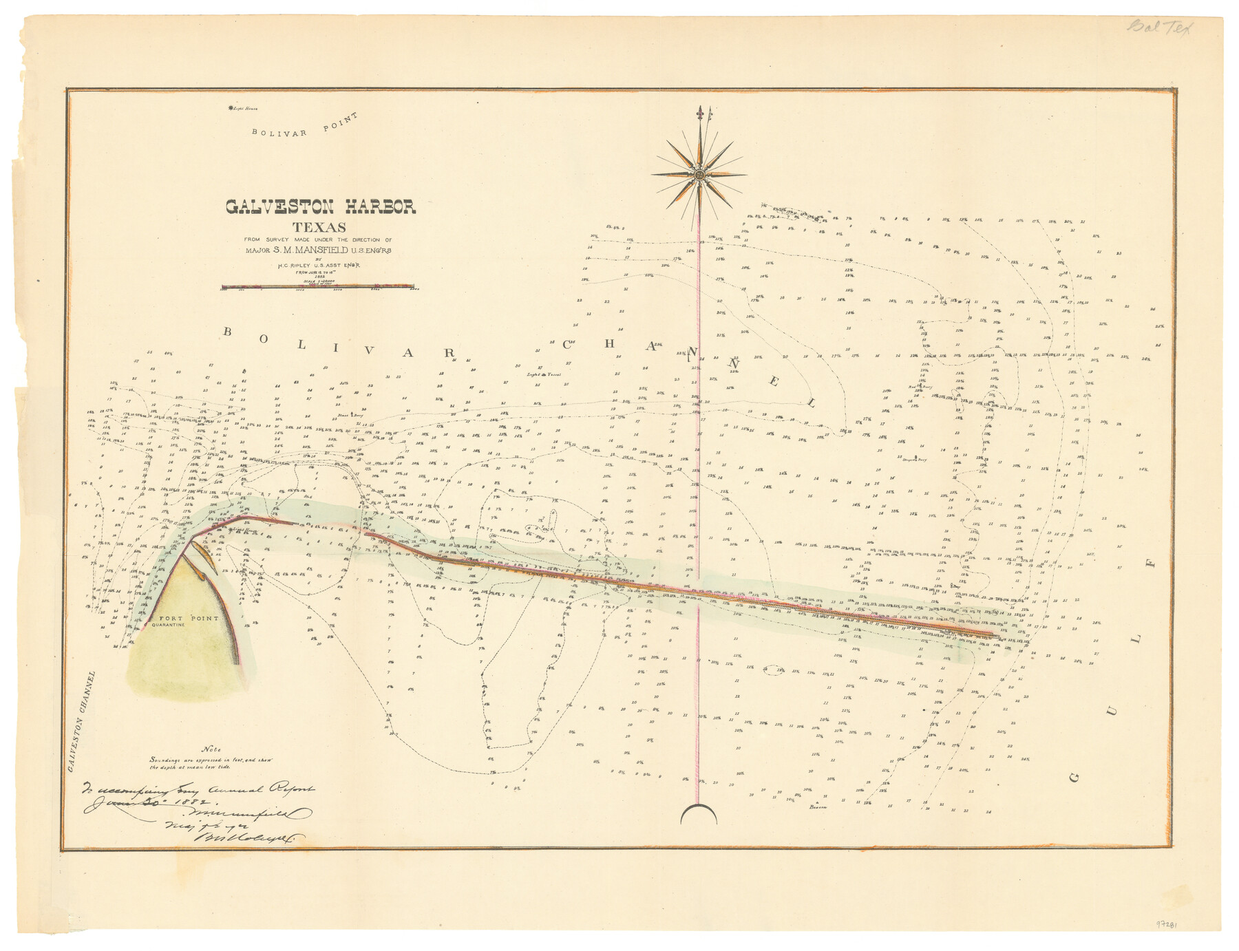
Galveston Harbor, Texas
-
Map/Doc
97281
-
Collection
General Map Collection
-
Object Dates
1882 (Creation Date)
-
People and Organizations
S.M. Mansfield (Surveyor/Engineer)
H.C. Ripley (Surveyor/Engineer)
Chase Untermeyer (Donor)
-
Subjects
Coastal Nautical Charts
-
Height x Width
15.0 x 19.5 inches
38.1 x 49.5 cm
-
Comments
Donated by Ambassador Chase Untermeyer in June 2024.
Part of: General Map Collection
Garza County Working Sketch 11

Print $3.00
- Digital $50.00
Garza County Working Sketch 11
1955
Size 14.5 x 10.9 inches
Map/Doc 63158
Shackelford County Boundary File 7b

Print $90.00
- Digital $50.00
Shackelford County Boundary File 7b
Size 7.9 x 10.4 inches
Map/Doc 58692
Montgomery County Working Sketch 30

Print $20.00
- Digital $50.00
Montgomery County Working Sketch 30
1946
Size 30.7 x 34.8 inches
Map/Doc 71137
Map of Bee County

Print $20.00
- Digital $50.00
Map of Bee County
1879
Size 25.3 x 22.8 inches
Map/Doc 3288
Edwards County Rolled Sketch 24

Print $20.00
- Digital $50.00
Edwards County Rolled Sketch 24
1953
Size 29.9 x 38.0 inches
Map/Doc 5810
Andrews County Rolled Sketch 37

Print $20.00
- Digital $50.00
Andrews County Rolled Sketch 37
Size 29.1 x 19.8 inches
Map/Doc 77179
USGS Topographic: Texas-Oklahoma Denison Quadrangle

Print $20.00
- Digital $50.00
USGS Topographic: Texas-Oklahoma Denison Quadrangle
1901
Size 21.3 x 17.4 inches
Map/Doc 75108
Township No. 5 South Range No. 11 West of the Indian Meridian

Print $20.00
- Digital $50.00
Township No. 5 South Range No. 11 West of the Indian Meridian
1875
Size 19.3 x 24.3 inches
Map/Doc 75160

Bailey County Working Sketch 3

Print $20.00
- Digital $50.00
Bailey County Working Sketch 3
1922
Size 17.3 x 28.0 inches
Map/Doc 67590
State Prison Lands in Walker County - Wynne Farm, Goree Farm, Dairy Pasture, Cemetery Tract

Print $20.00
- Digital $50.00
State Prison Lands in Walker County - Wynne Farm, Goree Farm, Dairy Pasture, Cemetery Tract
Size 16.9 x 19.1 inches
Map/Doc 62994
Real County Sketch File 17

Print $6.00
- Digital $50.00
Real County Sketch File 17
1942
Size 5.6 x 4.3 inches
Map/Doc 35073
You may also like
[H. &. T. C. RR. Company, Blocks 46 and 47]
![91172, [H. &. T. C. RR. Company, Blocks 46 and 47], Twichell Survey Records](https://historictexasmaps.com/wmedia_w700/maps/91172-1.tif.jpg)
Print $20.00
- Digital $50.00
[H. &. T. C. RR. Company, Blocks 46 and 47]
1888
Size 45.1 x 11.8 inches
Map/Doc 91172
Magnetic Declination in the United States - Epoch 1980

Print $20.00
- Digital $50.00
Magnetic Declination in the United States - Epoch 1980
1980
Size 41.4 x 33.3 inches
Map/Doc 92368
McMullen County, Texas

Print $20.00
- Digital $50.00
McMullen County, Texas
1889
Size 28.7 x 22.1 inches
Map/Doc 575
[Gunter & Munson and Surrounding Surveys]
![91238, [Gunter & Munson and Surrounding Surveys], Twichell Survey Records](https://historictexasmaps.com/wmedia_w700/maps/91238-1.tif.jpg)
Print $20.00
- Digital $50.00
[Gunter & Munson and Surrounding Surveys]
Size 16.3 x 21.4 inches
Map/Doc 91238
State of Texas, Wheeler County, Surveys 37-44-46, Block 17

Print $20.00
- Digital $50.00
State of Texas, Wheeler County, Surveys 37-44-46, Block 17
Size 19.4 x 13.0 inches
Map/Doc 92115
Flight Mission No. BQY-4M, Frame 54, Harris County

Print $20.00
- Digital $50.00
Flight Mission No. BQY-4M, Frame 54, Harris County
1953
Size 18.6 x 22.4 inches
Map/Doc 85263
[Subdivision Plat of 80 acres]
![93074, [Subdivision Plat of 80 acres], Twichell Survey Records](https://historictexasmaps.com/wmedia_w700/maps/93074-1.tif.jpg)
Print $2.00
- Digital $50.00
[Subdivision Plat of 80 acres]
Size 10.6 x 6.3 inches
Map/Doc 93074
[Map Showing Capitol Lands]
![93198, [Map Showing Capitol Lands], Twichell Survey Records](https://historictexasmaps.com/wmedia_w700/maps/93198-1.tif.jpg)
Print $40.00
- Digital $50.00
[Map Showing Capitol Lands]
Size 43.9 x 104.8 inches
Map/Doc 93198
[Sketch for Mineral Application 24072, San Jacinto River]
![65589, [Sketch for Mineral Application 24072, San Jacinto River], General Map Collection](https://historictexasmaps.com/wmedia_w700/maps/65589.tif.jpg)
Print $20.00
- Digital $50.00
[Sketch for Mineral Application 24072, San Jacinto River]
1929
Size 29.6 x 14.7 inches
Map/Doc 65589
Flight Mission No. CUG-3P, Frame 165, Kleberg County

Print $20.00
- Digital $50.00
Flight Mission No. CUG-3P, Frame 165, Kleberg County
1956
Size 18.5 x 22.2 inches
Map/Doc 86285

Orange County NRC Article 33.136 Sketch 4

Print $24.00
- Digital $50.00
Orange County NRC Article 33.136 Sketch 4
2011
Size 22.6 x 31.2 inches
Map/Doc 93271