Current Miscellaneous File 8

Print $10.00
- Digital $50.00
Current Miscellaneous File 8
Size: 14.6 x 9.1 inches
73736
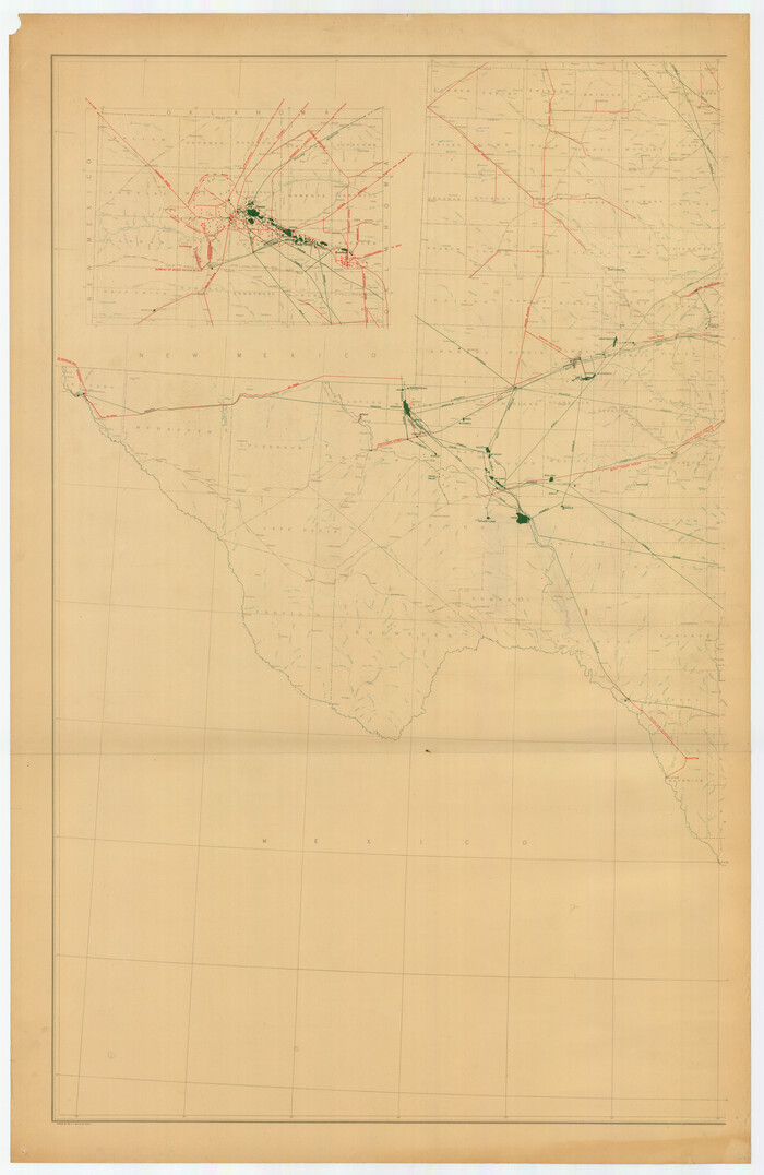
[Oil and Gas Fields in West Texas]
Print $40.00
- Digital $50.00
[Oil and Gas Fields in West Texas]
Size: 38.5 x 59.2 inches
89884

Oil Development and Structural Map showing Schott, Mirando and other oil fields of the Laredo District with present and proposed development.

Print $20.00
- Digital $50.00
Oil Development and Structural Map showing Schott, Mirando and other oil fields of the Laredo District with present and proposed development.
1920
Size: 11.3 x 8.9 inches
94107
Geological Map of the Great East Texas Oil Fields

Print $20.00
- Digital $50.00
Geological Map of the Great East Texas Oil Fields
1921
Size: 22.6 x 11.7 inches
94271
Texas-Louisiana Gulf Coastal Region showing Oil & Gas Fields & Prospects, Pipe Lines, Refineries & Principal Highways

Print $20.00
- Digital $50.00
Texas-Louisiana Gulf Coastal Region showing Oil & Gas Fields & Prospects, Pipe Lines, Refineries & Principal Highways
1933
Size: 22.4 x 44.2 inches
96874
A map of the Anthracite Coal Fields of Pennsylvania embracing all of Schuylkill County and parts of Carbon, Luzerne, Columbia, Northumberland, Dauphin, and Lebanon Counties

Print $20.00
- Digital $50.00
A map of the Anthracite Coal Fields of Pennsylvania embracing all of Schuylkill County and parts of Carbon, Luzerne, Columbia, Northumberland, Dauphin, and Lebanon Counties
1863
Size: 27.1 x 39.3 inches
94054
Gray's Geological Map of the United States

Print $20.00
- Digital $50.00
Gray's Geological Map of the United States
1873
Size: 17.6 x 28.8 inches
95174
Revised map of Jefferson County, Texas showing land surveys, railroads and water ways

Print $20.00
- Digital $50.00
Revised map of Jefferson County, Texas showing land surveys, railroads and water ways
1898
Size: 27.2 x 24.1 inches
95912
Clarke and Courts' Map of Jefferson County and Beaumont and Sour Lake Oil Fields

Print $20.00
Clarke and Courts' Map of Jefferson County and Beaumont and Sour Lake Oil Fields
1901
Size: 28.2 x 24.3 inches
79289
Geological Report on Robertson County

Print $20.00
- Digital $50.00
Geological Report on Robertson County
1918
Size: 21.7 x 25.8 inches
97084
Map of Central Texas Oil Fields

Print $20.00
Map of Central Texas Oil Fields
1918
Size: 27.1 x 21.5 inches
76295
Clason's Oil Map of Texas and Oklahoma showing the location and approximate area of the oil and gas fields

Print $20.00
- Digital $50.00
Clason's Oil Map of Texas and Oklahoma showing the location and approximate area of the oil and gas fields
1919
Size: 22.4 x 24.5 inches
97158
Geological Petroleum Corporation Map of North Central Texas

Print $20.00
Geological Petroleum Corporation Map of North Central Texas
1920
Size: 37.4 x 28.4 inches
79305
Gallup's Map of Texas

Print $20.00
- Digital $50.00
Gallup's Map of Texas
1920
Size: 22.4 x 31.9 inches
95696
Oil Map of Texas and Oklahoma showing the location and approximate area of the Oil and Gas Fields

Print $20.00
- Digital $50.00
Oil Map of Texas and Oklahoma showing the location and approximate area of the Oil and Gas Fields
1920
Size: 20.8 x 23.9 inches
95897
New Oil and Geological Map of Texas showing Oil Fields, Pipe Lines, Refineries, Geological Formations, Etc.

Print $20.00
- Digital $50.00
New Oil and Geological Map of Texas showing Oil Fields, Pipe Lines, Refineries, Geological Formations, Etc.
1920
Size: 22.5 x 31.3 inches
96633
Souvenir - Opening and Dedication of the General Oil Company's New West Texas Oil Field

Souvenir - Opening and Dedication of the General Oil Company's New West Texas Oil Field
1920
97263
[Sketch for Mineral Application 13436 - 13441]
Print $40.00
- Digital $50.00
[Sketch for Mineral Application 13436 - 13441]
1925
Size: 56.8 x 42.4 inches
65581
[Sketch for Mineral Application 13436 - 13441]
Print $40.00
- Digital $50.00
[Sketch for Mineral Application 13436 - 13441]
1925
Size: 56.8 x 42.5 inches
65582
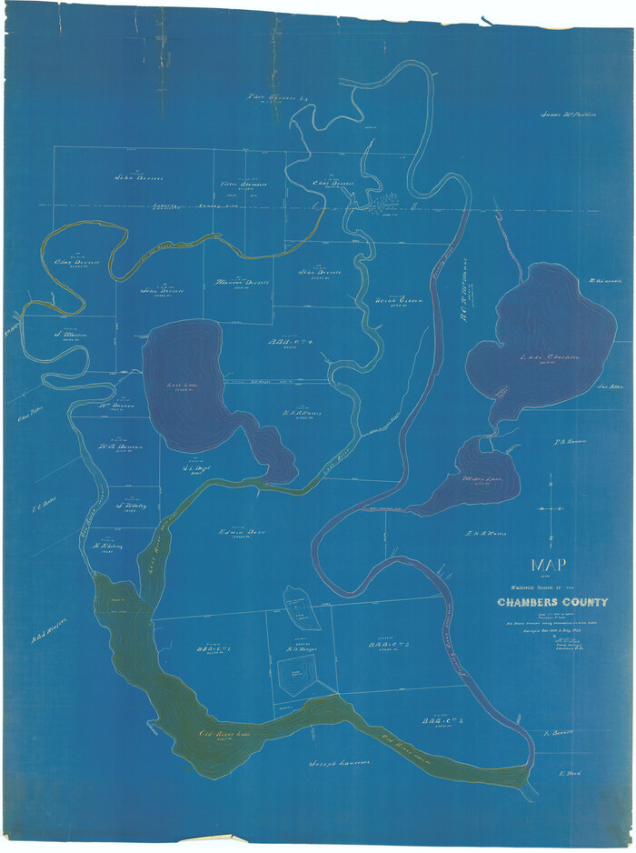
[Sketch for Mineral Application 13441 - Trinity River, Miller's Lake, Charlotte Lake, Florence Dunn]
Print $40.00
- Digital $50.00
[Sketch for Mineral Application 13441 - Trinity River, Miller's Lake, Charlotte Lake, Florence Dunn]
1925
Size: 104.1 x 43.3 inches
65657
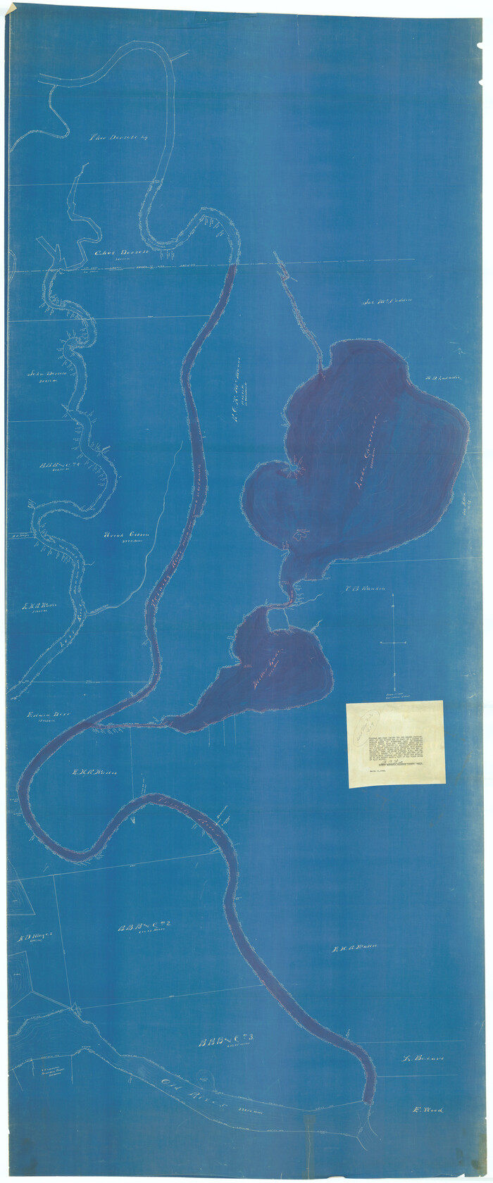
[Sketch for Mineral Application 13441 - Trinity River, Miller's Lake, Charlotte Lake, Florence Dunn]
Print $40.00
- Digital $50.00
[Sketch for Mineral Application 13441 - Trinity River, Miller's Lake, Charlotte Lake, Florence Dunn]
1925
Size: 103.6 x 43.1 inches
65658
Texas Oil and Gas Fields and Truck Pipe Line Systems

Print $20.00
Texas Oil and Gas Fields and Truck Pipe Line Systems
1926
Size: 21.7 x 30.8 inches
79327
Oil and Gas Fields in the State of Texas

Print $40.00
Oil and Gas Fields in the State of Texas
1927
Size: 58.0 x 38.0 inches
76304
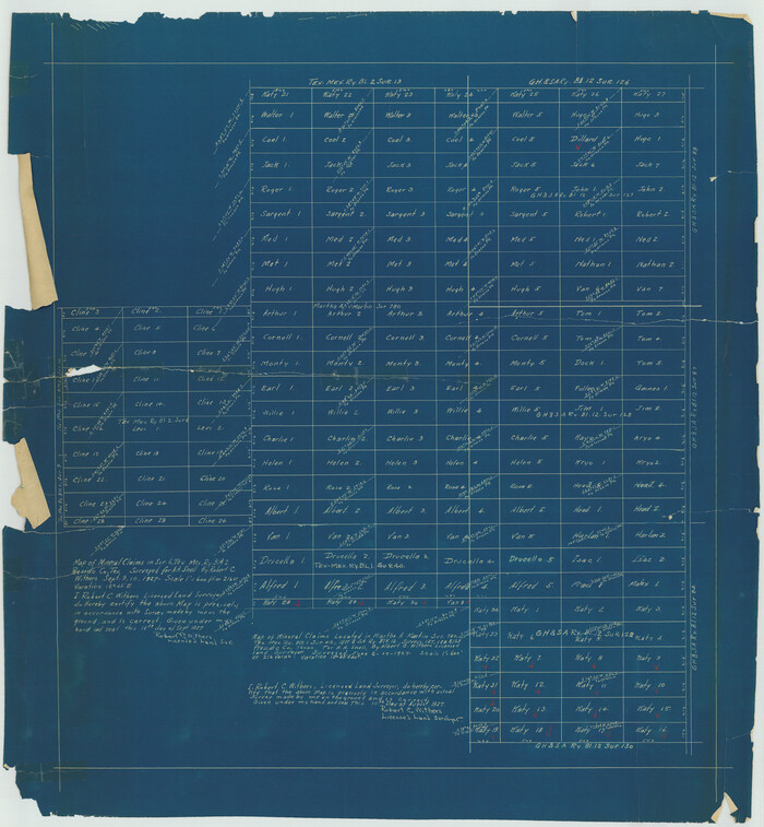
[Sketch for M-12871 to M-13240 - Presidio County]
Print $20.00
- Digital $50.00
[Sketch for M-12871 to M-13240 - Presidio County]
1927
Size: 33.0 x 30.5 inches
65649
[Sketch for M-12871 to M-13240 - Presidio County]
Print $20.00
- Digital $50.00
[Sketch for M-12871 to M-13240 - Presidio County]
1927
Size: 30.6 x 33.0 inches
65650
Oil and Gas Fields in the State of Texas

Print $40.00
Oil and Gas Fields in the State of Texas
1927
Size: 58.2 x 38.1 inches
76303
Oil and Gas Fields of the State of Texas

Print $40.00
- Digital $50.00
Oil and Gas Fields of the State of Texas
1931
Size: 38.4 x 59.2 inches
89885
Map of East Texas Oil Field

Print $20.00
- Digital $50.00
Map of East Texas Oil Field
1933
Size: 16.5 x 17.8 inches
93949
The Oil and Gas Journal's Oil Map of Texas

Print $20.00
- Digital $50.00
The Oil and Gas Journal's Oil Map of Texas
1938
Size: 38.3 x 39.4 inches
96970
Current Miscellaneous File 8
Print $10.00
- Digital $50.00
Current Miscellaneous File 8
-
Size
14.6 x 9.1 inches
-
Map/Doc
73736
[Oil and Gas Fields in West Texas]
Print $40.00
- Digital $50.00
[Oil and Gas Fields in West Texas]
-
Size
38.5 x 59.2 inches
-
Map/Doc
89884
Oil Development and Structural Map showing Schott, Mirando and other oil fields of the Laredo District with present and proposed development.
Print $20.00
- Digital $50.00
Oil Development and Structural Map showing Schott, Mirando and other oil fields of the Laredo District with present and proposed development.
1920
-
Size
11.3 x 8.9 inches
-
Map/Doc
94107
-
Creation Date
1920
Geological Map of the Great East Texas Oil Fields
Print $20.00
- Digital $50.00
Geological Map of the Great East Texas Oil Fields
1921
-
Size
22.6 x 11.7 inches
-
Map/Doc
94271
-
Creation Date
1921
Texas-Louisiana Gulf Coastal Region showing Oil & Gas Fields & Prospects, Pipe Lines, Refineries & Principal Highways
Print $20.00
- Digital $50.00
Texas-Louisiana Gulf Coastal Region showing Oil & Gas Fields & Prospects, Pipe Lines, Refineries & Principal Highways
1933
-
Size
22.4 x 44.2 inches
-
Map/Doc
96874
-
Creation Date
1933
A map of the Anthracite Coal Fields of Pennsylvania embracing all of Schuylkill County and parts of Carbon, Luzerne, Columbia, Northumberland, Dauphin, and Lebanon Counties
Print $20.00
- Digital $50.00
A map of the Anthracite Coal Fields of Pennsylvania embracing all of Schuylkill County and parts of Carbon, Luzerne, Columbia, Northumberland, Dauphin, and Lebanon Counties
1863
-
Size
27.1 x 39.3 inches
-
Map/Doc
94054
-
Creation Date
1863
Gray's Geological Map of the United States
Print $20.00
- Digital $50.00
Gray's Geological Map of the United States
1873
-
Size
17.6 x 28.8 inches
-
Map/Doc
95174
-
Creation Date
1873
Revised map of Jefferson County, Texas showing land surveys, railroads and water ways
Print $20.00
- Digital $50.00
Revised map of Jefferson County, Texas showing land surveys, railroads and water ways
1898
-
Size
27.2 x 24.1 inches
-
Map/Doc
95912
-
Creation Date
1898
Clarke and Courts' Map of Jefferson County and Beaumont and Sour Lake Oil Fields
Print $20.00
Clarke and Courts' Map of Jefferson County and Beaumont and Sour Lake Oil Fields
1901
-
Size
28.2 x 24.3 inches
-
Map/Doc
79289
-
Creation Date
1901
Geological Report on Robertson County
Print $20.00
- Digital $50.00
Geological Report on Robertson County
1918
-
Size
21.7 x 25.8 inches
-
Map/Doc
97084
-
Creation Date
1918
Map of Central Texas Oil Fields
Print $20.00
Map of Central Texas Oil Fields
1918
-
Size
27.1 x 21.5 inches
-
Map/Doc
76295
-
Creation Date
1918
Clason's Oil Map of Texas and Oklahoma showing the location and approximate area of the oil and gas fields
Print $20.00
- Digital $50.00
Clason's Oil Map of Texas and Oklahoma showing the location and approximate area of the oil and gas fields
1919
-
Size
22.4 x 24.5 inches
-
Map/Doc
97158
-
Creation Date
1919
Geological Petroleum Corporation Map of North Central Texas
Print $20.00
Geological Petroleum Corporation Map of North Central Texas
1920
-
Size
37.4 x 28.4 inches
-
Map/Doc
79305
-
Creation Date
1920
Gallup's Map of Texas
Print $20.00
- Digital $50.00
Gallup's Map of Texas
1920
-
Size
22.4 x 31.9 inches
-
Map/Doc
95696
-
Creation Date
1920
Oil Map of Texas and Oklahoma showing the location and approximate area of the Oil and Gas Fields
Print $20.00
- Digital $50.00
Oil Map of Texas and Oklahoma showing the location and approximate area of the Oil and Gas Fields
1920
-
Size
20.8 x 23.9 inches
-
Map/Doc
95897
-
Creation Date
1920
New Oil and Geological Map of Texas showing Oil Fields, Pipe Lines, Refineries, Geological Formations, Etc.
Print $20.00
- Digital $50.00
New Oil and Geological Map of Texas showing Oil Fields, Pipe Lines, Refineries, Geological Formations, Etc.
1920
-
Size
22.5 x 31.3 inches
-
Map/Doc
96633
-
Creation Date
1920
Souvenir - Opening and Dedication of the General Oil Company's New West Texas Oil Field
Souvenir - Opening and Dedication of the General Oil Company's New West Texas Oil Field
1920
-
Map/Doc
97263
-
Creation Date
1920
[Sketch for Mineral Application 13436 - 13441]
Print $40.00
- Digital $50.00
[Sketch for Mineral Application 13436 - 13441]
1925
-
Size
56.8 x 42.4 inches
-
Map/Doc
65581
-
Creation Date
1925
[Sketch for Mineral Application 13436 - 13441]
Print $40.00
- Digital $50.00
[Sketch for Mineral Application 13436 - 13441]
1925
-
Size
56.8 x 42.5 inches
-
Map/Doc
65582
-
Creation Date
1925
[Sketch for Mineral Application 13441 - Trinity River, Miller's Lake, Charlotte Lake, Florence Dunn]
Print $40.00
- Digital $50.00
[Sketch for Mineral Application 13441 - Trinity River, Miller's Lake, Charlotte Lake, Florence Dunn]
1925
-
Size
104.1 x 43.3 inches
-
Map/Doc
65657
-
Creation Date
1925
[Sketch for Mineral Application 13441 - Trinity River, Miller's Lake, Charlotte Lake, Florence Dunn]
Print $40.00
- Digital $50.00
[Sketch for Mineral Application 13441 - Trinity River, Miller's Lake, Charlotte Lake, Florence Dunn]
1925
-
Size
103.6 x 43.1 inches
-
Map/Doc
65658
-
Creation Date
1925
Texas Oil and Gas Fields and Truck Pipe Line Systems
Print $20.00
Texas Oil and Gas Fields and Truck Pipe Line Systems
1926
-
Size
21.7 x 30.8 inches
-
Map/Doc
79327
-
Creation Date
1926
Oil and Gas Fields in the State of Texas
Print $40.00
Oil and Gas Fields in the State of Texas
1927
-
Size
58.0 x 38.0 inches
-
Map/Doc
76304
-
Creation Date
1927
[Sketch for M-12871 to M-13240 - Presidio County]
Print $20.00
- Digital $50.00
[Sketch for M-12871 to M-13240 - Presidio County]
1927
-
Size
33.0 x 30.5 inches
-
Map/Doc
65649
-
Creation Date
1927
[Sketch for M-12871 to M-13240 - Presidio County]
Print $20.00
- Digital $50.00
[Sketch for M-12871 to M-13240 - Presidio County]
1927
-
Size
30.6 x 33.0 inches
-
Map/Doc
65650
-
Creation Date
1927
Oil and Gas Fields in the State of Texas
Print $40.00
Oil and Gas Fields in the State of Texas
1927
-
Size
58.2 x 38.1 inches
-
Map/Doc
76303
-
Creation Date
1927
Oil and Gas Fields of the State of Texas
Print $40.00
- Digital $50.00
Oil and Gas Fields of the State of Texas
1931
-
Size
38.4 x 59.2 inches
-
Map/Doc
89885
-
Creation Date
1931
Map of East Texas Oil Field
Print $20.00
- Digital $50.00
Map of East Texas Oil Field
1933
-
Size
16.5 x 17.8 inches
-
Map/Doc
93949
-
Creation Date
1933
The Oil and Gas Journal's Oil Map of Texas
Print $20.00
- Digital $50.00
The Oil and Gas Journal's Oil Map of Texas
1938
-
Size
38.3 x 39.4 inches
-
Map/Doc
96970
-
Creation Date
1938