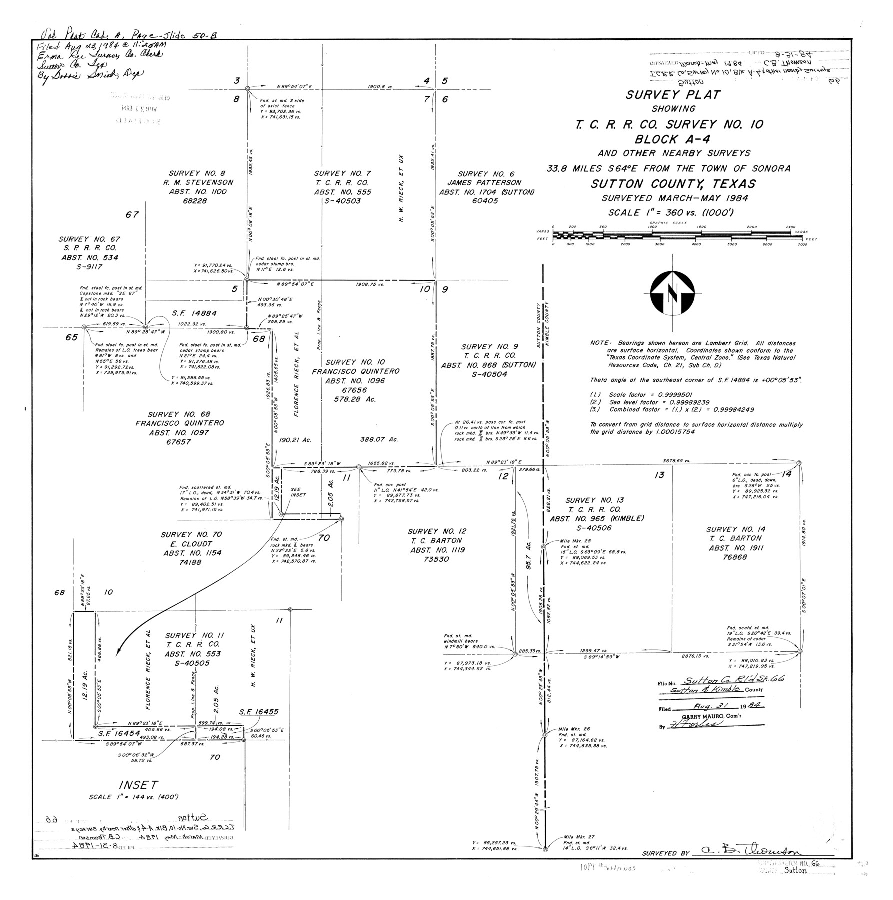
Sutton County Rolled Sketch 66
Survey plat showing T. C. R.R. Co. survey no. 10, Block A-4 and other nearby surveys
-
Map/Doc
7901
-
Collection
General Map Collection
-
Object Dates
1984 (Survey Date)
1984/8/31 (File Date)
-
People and Organizations
C.B. Thomson (Surveyor/Engineer)
-
Counties
Sutton Kimble
-
Subjects
Surveying Rolled Sketch
-
Height x Width
25.3 x 25.1 inches
64.3 x 63.8 cm
-
Medium
mylar, print
-
Scale
1" = 360 varas
Part of: General Map Collection
Map of Comanche County

Print $20.00
- Digital $50.00
Map of Comanche County
1884
Size 20.9 x 26.5 inches
Map/Doc 3434
Real County Working Sketch 65

Print $20.00
- Digital $50.00
Real County Working Sketch 65
1969
Size 31.1 x 23.4 inches
Map/Doc 71957
Wood County Working Sketch 19

Print $20.00
- Digital $50.00
Wood County Working Sketch 19
1982
Size 25.8 x 24.8 inches
Map/Doc 62019
Winkler County Sketch File 13

Print $20.00
- Digital $50.00
Winkler County Sketch File 13
Size 15.9 x 19.7 inches
Map/Doc 12697
Atascosa County Working Sketch 26

Print $20.00
- Digital $50.00
Atascosa County Working Sketch 26
1960
Size 46.9 x 43.7 inches
Map/Doc 67222
Fort Bend County Sketch File 12

Print $20.00
- Digital $50.00
Fort Bend County Sketch File 12
Size 24.6 x 18.2 inches
Map/Doc 11503
Map of Travis County

Print $20.00
- Digital $50.00
Map of Travis County
1861
Size 24.0 x 28.6 inches
Map/Doc 4088
Menard County Sketch File 23

Print $20.00
- Digital $50.00
Menard County Sketch File 23
1927
Size 21.2 x 31.1 inches
Map/Doc 12076
Flight Mission No. BRE-2P, Frame 105, Nueces County

Print $20.00
- Digital $50.00
Flight Mission No. BRE-2P, Frame 105, Nueces County
1956
Size 18.4 x 22.2 inches
Map/Doc 86790
Flight Mission No. BQR-3K, Frame 84, Brazoria County

Print $20.00
- Digital $50.00
Flight Mission No. BQR-3K, Frame 84, Brazoria County
1952
Size 18.8 x 22.5 inches
Map/Doc 83976
Aransas County Rolled Sketch 28

Print $20.00
- Digital $50.00
Aransas County Rolled Sketch 28
1987
Size 24.5 x 30.9 inches
Map/Doc 77496
Taylor County Working Sketch 21

Print $40.00
- Digital $50.00
Taylor County Working Sketch 21
1985
Size 55.9 x 43.8 inches
Map/Doc 69631
You may also like
Borden County

Print $20.00
- Digital $50.00
Borden County
1892
Size 44.1 x 44.1 inches
Map/Doc 66717


Flight Mission No. DCL-7C, Frame 43, Kenedy County

Print $20.00
- Digital $50.00
Flight Mission No. DCL-7C, Frame 43, Kenedy County
1943
Size 15.5 x 15.5 inches
Map/Doc 86031
Beales and Royuela Empresario Colony. March 14, 1832

Print $20.00
Beales and Royuela Empresario Colony. March 14, 1832
2020
Size 19.4 x 21.6 inches
Map/Doc 95984
Photo Index of Texas Coast - Sheet 5 of 6

Print $20.00
- Digital $50.00
Photo Index of Texas Coast - Sheet 5 of 6
1954
Size 20.0 x 24.0 inches
Map/Doc 83443
Grimes County Sketch File 4a

Print $6.00
- Digital $50.00
Grimes County Sketch File 4a
1873
Size 13.0 x 8.4 inches
Map/Doc 24656
Cottle County Sketch File 7

Print $20.00
- Digital $50.00
Cottle County Sketch File 7
1893
Size 22.1 x 20.7 inches
Map/Doc 11191
A New Map of Texas with the contiguous American and Mexican States

Print $20.00
- Digital $50.00
A New Map of Texas with the contiguous American and Mexican States
1839
Size 13.0 x 15.4 inches
Map/Doc 96513
[Worksheets related to the Wilson Strickland survey and vicinity]
![91391, [Worksheets related to the Wilson Strickland survey and vicinity], Twichell Survey Records](https://historictexasmaps.com/wmedia_w700/maps/91391-1.tif.jpg)
Print $20.00
- Digital $50.00
[Worksheets related to the Wilson Strickland survey and vicinity]
Size 42.8 x 19.6 inches
Map/Doc 91391
Terrell County Working Sketch 2

Print $20.00
- Digital $50.00
Terrell County Working Sketch 2
1908
Size 19.8 x 24.2 inches
Map/Doc 62150
Lovington Lea County, N. M. Lots 11, 14-Sec. 4-16-36

Print $40.00
- Digital $50.00
Lovington Lea County, N. M. Lots 11, 14-Sec. 4-16-36
Size 28.8 x 49.9 inches
Map/Doc 89694