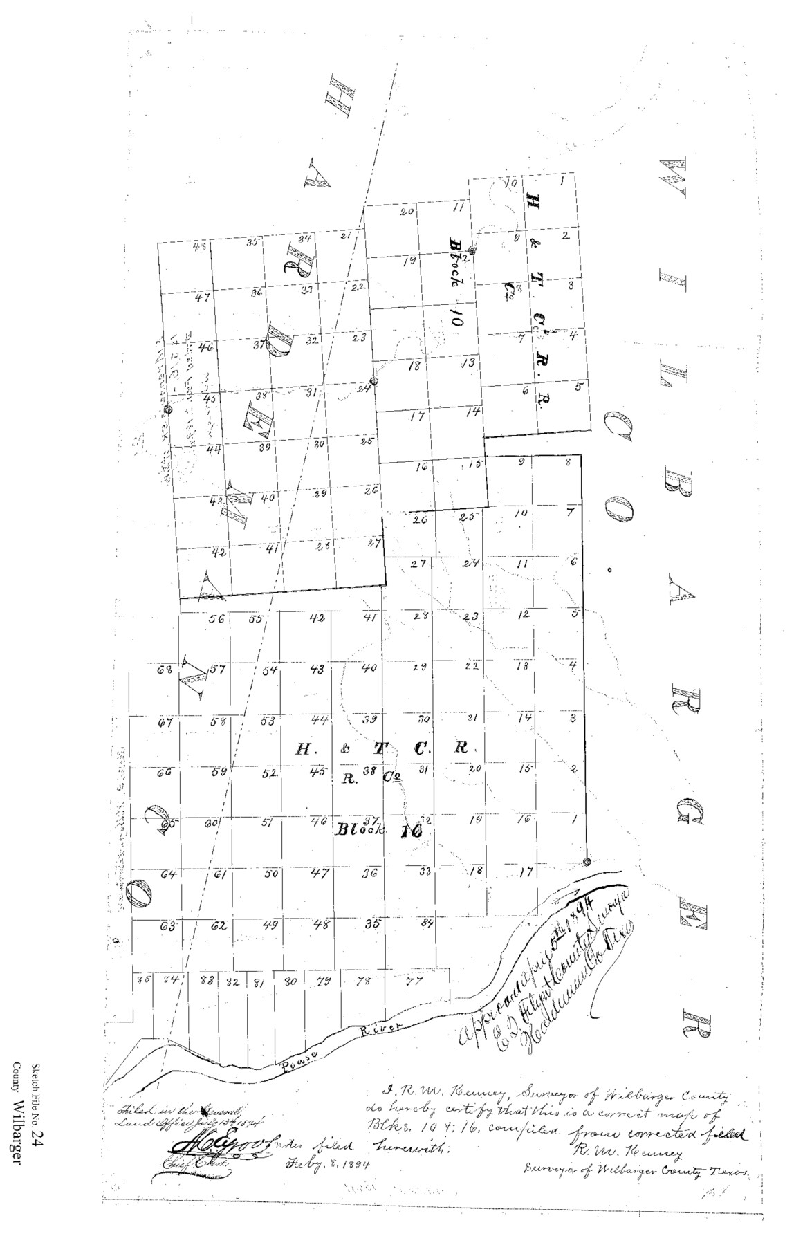
Wilbarger County Sketch File 24
[Sketch of surveys in H. & T. C. R.R. Co. Blocks 10 and 16 north of the Pease River]
-
Map/Doc
12691
-
Collection
General Map Collection
-
Object Dates
2/8/1894 (Creation Date)
7/13/1894 (File Date)
-
People and Organizations
R.M. Kenney (Surveyor/Engineer)
-
Counties
Wilbarger Hardeman
-
Subjects
Surveying Sketch File
-
Height x Width
23.3 x 14.9 inches
59.2 x 37.9 cm
-
Medium
paper, print
-
Features
Pease River
Part of: General Map Collection
Van Zandt County Sketch File 35

Print $4.00
- Digital $50.00
Van Zandt County Sketch File 35
1862
Size 12.7 x 8.2 inches
Map/Doc 39474
Flight Mission No. DAH-9M, Frame 83, Orange County

Print $20.00
- Digital $50.00
Flight Mission No. DAH-9M, Frame 83, Orange County
1953
Size 18.5 x 22.3 inches
Map/Doc 86847
Sutton County Rolled Sketch 55

Print $40.00
- Digital $50.00
Sutton County Rolled Sketch 55
1954
Size 59.9 x 39.9 inches
Map/Doc 9976
Victoria County

Print $20.00
- Digital $50.00
Victoria County
1895
Size 29.7 x 25.7 inches
Map/Doc 4118
Cameron County Rolled Sketch 20D

Print $20.00
- Digital $50.00
Cameron County Rolled Sketch 20D
Size 13.7 x 12.1 inches
Map/Doc 5476

Cass County Sketch File 4

Print $6.00
- Digital $50.00
Cass County Sketch File 4
1853
Size 8.2 x 11.2 inches
Map/Doc 17398
Roberts County Boundary File 2d

Print $20.00
- Digital $50.00
Roberts County Boundary File 2d
Size 9.1 x 28.1 inches
Map/Doc 58366
Aransas County Sketch File 22

Print $34.00
- Digital $50.00
Aransas County Sketch File 22
1910
Size 14.8 x 9.1 inches
Map/Doc 13166
Comanche County Sketch File 18

Print $4.00
- Digital $50.00
Comanche County Sketch File 18
Size 8.4 x 7.8 inches
Map/Doc 19091
Hemphill County Working Sketch 25

Print $40.00
- Digital $50.00
Hemphill County Working Sketch 25
1974
Size 44.0 x 60.7 inches
Map/Doc 66120
Edwards County Working Sketch 120

Print $40.00
- Digital $50.00
Edwards County Working Sketch 120
1975
Size 25.0 x 48.9 inches
Map/Doc 68996
You may also like
Live Oak County Rolled Sketch 7

Print $20.00
- Digital $50.00
Live Oak County Rolled Sketch 7
1951
Size 31.3 x 36.9 inches
Map/Doc 6635
[Sketch of part of G. & M. Block 5, G. & M. Block 4, Block M19 and Block 21W]
![93079, [Sketch of part of G. & M. Block 5, G. & M. Block 4, Block M19 and Block 21W], Twichell Survey Records](https://historictexasmaps.com/wmedia_w700/maps/93079-1.tif.jpg)
Print $20.00
- Digital $50.00
[Sketch of part of G. & M. Block 5, G. & M. Block 4, Block M19 and Block 21W]
Size 22.8 x 15.6 inches
Map/Doc 93079
Tom Green County Sketch File 76

Print $20.00
- Digital $50.00
Tom Green County Sketch File 76
1951
Size 24.5 x 24.7 inches
Map/Doc 12450
Pecos County Rolled Sketch 79

Print $20.00
- Digital $50.00
Pecos County Rolled Sketch 79
1930
Size 28.5 x 32.6 inches
Map/Doc 7239
Val Verde County Sketch File XXX10

Print $20.00
- Digital $50.00
Val Verde County Sketch File XXX10
Size 25.9 x 19.2 inches
Map/Doc 12549
Flight Mission No. DQN-1K, Frame 157, Calhoun County

Print $20.00
- Digital $50.00
Flight Mission No. DQN-1K, Frame 157, Calhoun County
1953
Size 18.4 x 22.2 inches
Map/Doc 84216
Lee County Working Sketch 12

Print $20.00
- Digital $50.00
Lee County Working Sketch 12
1980
Size 12.3 x 16.3 inches
Map/Doc 70391
Map of Taylor County

Print $20.00
- Digital $50.00
Map of Taylor County
1858
Size 24.0 x 25.3 inches
Map/Doc 4070
A New Map of Nebraska, Kansas, New Mexico and Indian Territories

Print $20.00
- Digital $50.00
A New Map of Nebraska, Kansas, New Mexico and Indian Territories
Size 18.6 x 15.2 inches
Map/Doc 93985
Flight Mission No. CRC-3R, Frame 27, Chambers County

Print $20.00
- Digital $50.00
Flight Mission No. CRC-3R, Frame 27, Chambers County
1956
Size 18.7 x 22.3 inches
Map/Doc 84801
Callahan County Rolled Sketch 5

Print $40.00
- Digital $50.00
Callahan County Rolled Sketch 5
Size 52.0 x 44.1 inches
Map/Doc 5382
Nueces River, North Extension Clarkwood Sheet

Print $2.00
- Digital $50.00
Nueces River, North Extension Clarkwood Sheet
1942
Size 14.5 x 17.7 inches
Map/Doc 65100