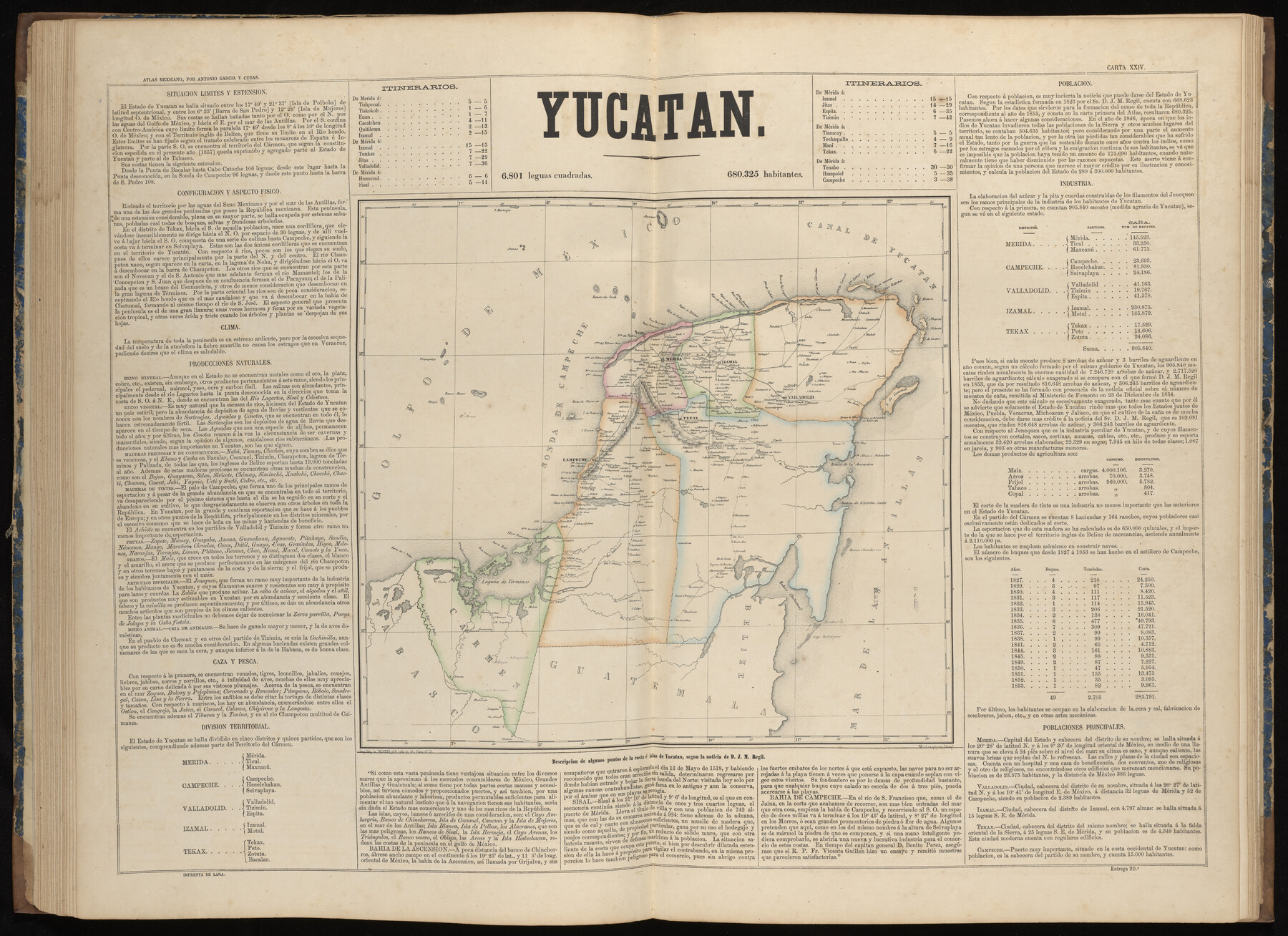
Yucatan
-
Map/Doc
97005
-
Collection
General Map Collection
-
Object Dates
1858 (Publication Date)
-
People and Organizations
Antonio García y Cubas (Cartographer)
-
Subjects
Atlas Mexico
-
Height x Width
23.0 x 31.6 inches
58.4 x 80.3 cm
-
Medium
paper, etching/engraving/lithograph
-
Comments
Map 24 of 32 from "Atlas Geografico, Estadistico e Historico de la Republica Mexicana" (95689)
Related maps
Atlas Geográfico, Estadístico é Histórico de la República Mexicana

Atlas Geográfico, Estadístico é Histórico de la República Mexicana
Map/Doc 95689
Part of: General Map Collection
Flight Mission No. BRE-1P, Frame 105, Nueces County

Print $20.00
- Digital $50.00
Flight Mission No. BRE-1P, Frame 105, Nueces County
1956
Size 18.4 x 22.2 inches
Map/Doc 86676
Montgomery County Working Sketch 12

Print $20.00
- Digital $50.00
Montgomery County Working Sketch 12
1933
Size 32.5 x 31.9 inches
Map/Doc 71119
Cherokee County Sketch File 3

Print $4.00
- Digital $50.00
Cherokee County Sketch File 3
1849
Size 7.5 x 11.0 inches
Map/Doc 18115
Brazoria County NRC Article 33.136 Sketch 26

Print $24.00
Brazoria County NRC Article 33.136 Sketch 26
2025
Map/Doc 97471
Travis County Working Sketch 50

Print $20.00
- Digital $50.00
Travis County Working Sketch 50
1984
Size 37.8 x 29.0 inches
Map/Doc 69434
Amistad International Reservoir on Rio Grande 71a

Print $20.00
- Digital $50.00
Amistad International Reservoir on Rio Grande 71a
1949
Size 28.4 x 39.6 inches
Map/Doc 73359
Flight Mission No. DQO-3K, Frame 14, Galveston County

Print $20.00
- Digital $50.00
Flight Mission No. DQO-3K, Frame 14, Galveston County
1952
Size 18.8 x 22.4 inches
Map/Doc 85055
Map of the District of San Patricio and Nueces

Print $40.00
- Digital $50.00
Map of the District of San Patricio and Nueces
Size 93.8 x 38.4 inches
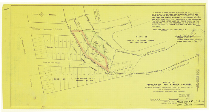
Map/Doc 93366
Dallas County Rolled Sketch 4A
Print $20.00
- Digital $50.00
Dallas County Rolled Sketch 4A
1954
Size 12.5 x 23.1 inches
Map/Doc 5688
Montgomery County Working Sketch 34

Print $20.00
- Digital $50.00
Montgomery County Working Sketch 34
1952
Size 43.0 x 35.8 inches
Map/Doc 71141
Navigation Maps of Gulf Intracoastal Waterway, Port Arthur to Brownsville, Texas

Print $4.00
- Digital $50.00
Navigation Maps of Gulf Intracoastal Waterway, Port Arthur to Brownsville, Texas
1951
Size 16.6 x 21.5 inches
Map/Doc 65436
Gaines County Sketch File 24

Print $6.00
- Digital $50.00
Gaines County Sketch File 24
1995
Size 8.7 x 3.8 inches
Map/Doc 76362
You may also like
Real County Working Sketch 53

Print $20.00
- Digital $50.00
Real County Working Sketch 53
1959
Size 29.4 x 27.9 inches
Map/Doc 71945
Flight Mission No. BQR-22K, Frame 46, Brazoria County

Print $20.00
- Digital $50.00
Flight Mission No. BQR-22K, Frame 46, Brazoria County
1953
Size 18.6 x 22.4 inches
Map/Doc 84130
[H. & T. C. RR. Company, Block 47 and vicinity]
![91156, [H. & T. C. RR. Company, Block 47 and vicinity], Twichell Survey Records](https://historictexasmaps.com/wmedia_w700/maps/91156-1.tif.jpg)
Print $20.00
- Digital $50.00
[H. & T. C. RR. Company, Block 47 and vicinity]
Size 18.2 x 19.3 inches
Map/Doc 91156
Briscoe County Sketch File 1

Print $5.00
- Digital $50.00
Briscoe County Sketch File 1
1880
Size 9.1 x 14.8 inches
Map/Doc 16413
Robertson County Working Sketch 13

Print $20.00
- Digital $50.00
Robertson County Working Sketch 13
1987
Size 28.0 x 29.4 inches
Map/Doc 63586
Intracoastal Waterway, Houma, LA to Corpus Christi, TX

Print $4.00
- Digital $50.00
Intracoastal Waterway, Houma, LA to Corpus Christi, TX
Size 23.8 x 22.0 inches
Map/Doc 61910
Garza County Rolled Sketch 13

Print $26.00
- Digital $50.00
Garza County Rolled Sketch 13
1935
Size 45.5 x 36.7 inches
Map/Doc 9047
Ellis County Sketch File 7

Print $40.00
- Digital $50.00
Ellis County Sketch File 7
1859
Size 12.2 x 15.6 inches
Map/Doc 21839
Nueces County Rolled Sketch 60

Print $40.00
- Digital $50.00
Nueces County Rolled Sketch 60
Size 95.5 x 32.3 inches
Map/Doc 9607
The United States of America

Print $20.00
- Digital $50.00
The United States of America
1866
Size 21.3 x 18.3 inches
Map/Doc 72646
Polk County Sketch File 27

Print $8.00
- Digital $50.00
Polk County Sketch File 27
1891
Size 14.1 x 8.7 inches
Map/Doc 34194
Frio County Rolled Sketch 15

Print $20.00
- Digital $50.00
Frio County Rolled Sketch 15
1949
Size 26.1 x 39.0 inches
Map/Doc 5922