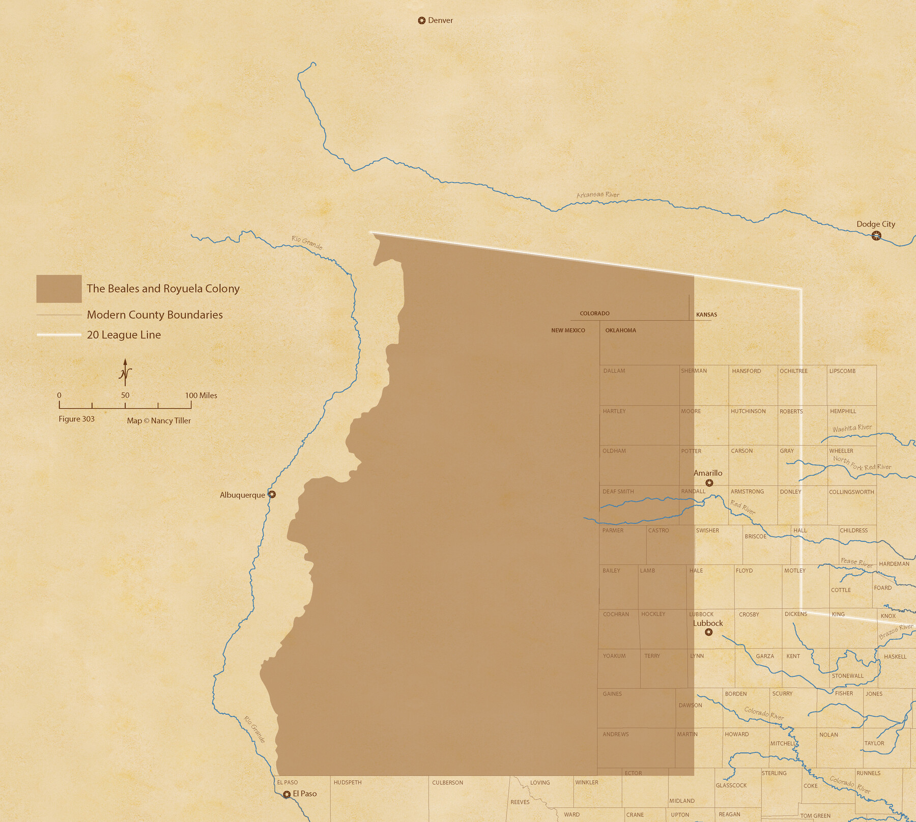
Beales and Royuela Empresario Colony. March 14, 1832
Figure No. 303 from 'A Boundary Atlas of Texas, 1821-1845' by Jim Tiller
-
Map/Doc
95984
-
Collection
Nancy and Jim Tiller Digital Collection
-
Object Dates
2020/1/1 (Creation Date)
-
People and Organizations
Jim Tiller (Author)
Nancy Tiller (Cartographer)
Gang Gong (GIS Professional)
-
Subjects
Atlas Colony Mexican Texas Texas Boundaries
-
Height x Width
19.4 x 21.6 inches
49.3 x 54.9 cm
-
Medium
digital image
-
Comments
To purchase a digital PDF copy of "A Boundary Atlas of Texas, 1821-1845" see 96437.
Part of: Nancy and Jim Tiller Digital Collection
Austin Empresario Colony. January 17, 1821/February 18, 1823

Print $20.00
Austin Empresario Colony. January 17, 1821/February 18, 1823
2020
Size 18.8 x 21.6 inches
Map/Doc 95978
The Republic County of Red River. December 29, 1845

Print $20.00
The Republic County of Red River. December 29, 1845
2020
Size 21.0 x 21.7 inches
Map/Doc 96255
The Republic County of Lamar. Created, December 17, 1840

Print $20.00
The Republic County of Lamar. Created, December 17, 1840
2020
Size 16.4 x 21.7 inches
Map/Doc 96202
The Republic County of Milam. January 29, 1842

Print $20.00
The Republic County of Milam. January 29, 1842
2020
Size 17.4 x 21.6 inches
Map/Doc 96231
The Republic County of Liberty. Spring 1842

Print $20.00
The Republic County of Liberty. Spring 1842
2020
Size 19.9 x 21.7 inches
Map/Doc 96212
The Judicial District/County of Hamilton. Abolished, Spring 1842

Print $20.00
The Judicial District/County of Hamilton. Abolished, Spring 1842
2020
Size 14.9 x 21.7 inches
Map/Doc 96330
Power and Hewetson Empresario Colony. April 2, 1829

Print $20.00
Power and Hewetson Empresario Colony. April 2, 1829
2020
Size 17.5 x 21.6 inches
Map/Doc 96004
The Republic County of Austin. Proposed, Late Fall 1837

Print $20.00
The Republic County of Austin. Proposed, Late Fall 1837
2020
Size 14.8 x 21.7 inches
Map/Doc 96080
The Republic County of Bexar. South View. Proposed, Fall 1837-December 31, 1838

Print $20.00
The Republic County of Bexar. South View. Proposed, Fall 1837-December 31, 1838
2020
Size 14.7 x 22.3 inches
Map/Doc 96095
The Republic County of Houston. December 6, 1841

Print $20.00
The Republic County of Houston. December 6, 1841
2020
Size 19.7 x 21.8 inches
Map/Doc 96180
The Republic County of Goliad. 1840

Print $20.00
The Republic County of Goliad. 1840
2020
Size 15.1 x 21.7 inches
Map/Doc 96150
The Mexican Municipality of Brazoria. March 6, 1834

Print $20.00
The Mexican Municipality of Brazoria. March 6, 1834
2020
Size 16.0 x 21.7 inches
Map/Doc 96016
You may also like
Phelps's National Map of the United States, a Travellers Guide. Embracing the principal railroads, canals, steamboat & stage routes, throughout the Union

Print $20.00
- Digital $50.00
Phelps's National Map of the United States, a Travellers Guide. Embracing the principal railroads, canals, steamboat & stage routes, throughout the Union
1849
Size 20.9 x 26.3 inches
Map/Doc 95901
Flight Mission No. CUG-3P, Frame 77, Kleberg County

Print $20.00
- Digital $50.00
Flight Mission No. CUG-3P, Frame 77, Kleberg County
1956
Size 18.7 x 22.4 inches
Map/Doc 86252
Bobalet Heights

Print $20.00
- Digital $50.00
Bobalet Heights
1941
Size 35.6 x 36.5 inches
Map/Doc 92787
Pecos County Rolled Sketch 165

Print $20.00
- Digital $50.00
Pecos County Rolled Sketch 165
1966
Size 23.4 x 19.6 inches
Map/Doc 7290
Flight Mission No. BQR-9K, Frame 13, Brazoria County

Print $20.00
- Digital $50.00
Flight Mission No. BQR-9K, Frame 13, Brazoria County
1952
Size 19.0 x 22.6 inches
Map/Doc 84042
Cameron County Aerial Photograph Index Sheet 5

Print $20.00
- Digital $50.00
Cameron County Aerial Photograph Index Sheet 5
1940
Size 20.4 x 24.3 inches
Map/Doc 83681
Motley County Sketch File DD (S)

Print $22.00
- Digital $50.00
Motley County Sketch File DD (S)
Size 10.9 x 7.1 inches
Map/Doc 32159
Jack County Boundary File 3

Print $10.00
- Digital $50.00
Jack County Boundary File 3
Size 9.2 x 4.0 inches
Map/Doc 55408
Dallam County Sketch File 11

Print $4.00
- Digital $50.00
Dallam County Sketch File 11
1935
Size 11.8 x 7.2 inches
Map/Doc 20377
Johnson County Working Sketch 26

Print $20.00
- Digital $50.00
Johnson County Working Sketch 26
2005
Size 22.3 x 41.8 inches
Map/Doc 83574
Flight Mission No. BRA-7M, Frame 77, Jefferson County

Print $20.00
- Digital $50.00
Flight Mission No. BRA-7M, Frame 77, Jefferson County
1953
Size 16.0 x 16.0 inches
Map/Doc 85499
Official Highway Map of Texas

Print $20.00
Official Highway Map of Texas
1928
Size 42.3 x 46.2 inches
Map/Doc 79746