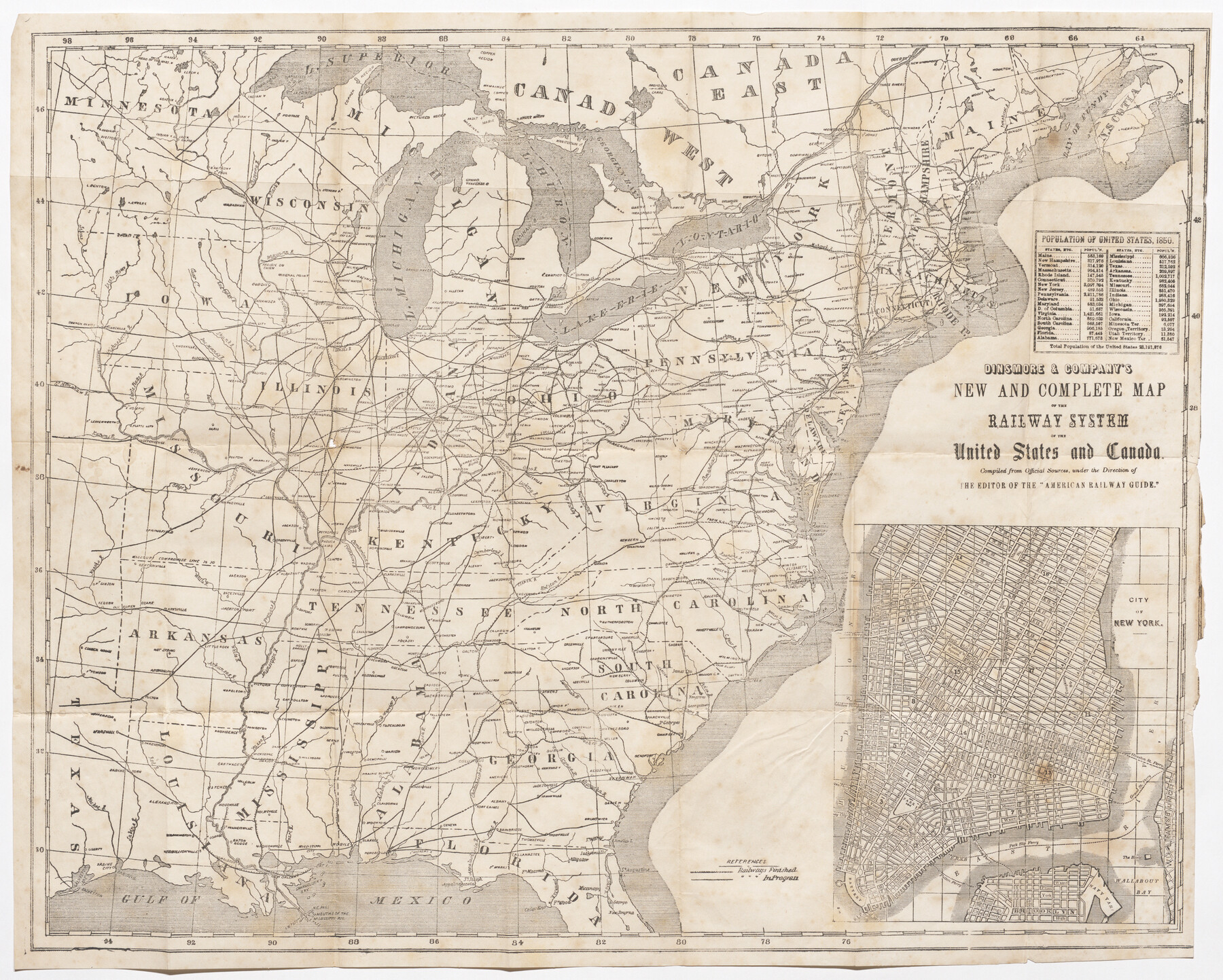
Dinsmore & Company's New and Complete Map of the Railway System of the United States and Canada compiled from official sources, under the direction of the editor of the "American Railway Guide"
[Inset:] City of New York
-
Map/Doc
95903
-
Collection
Cobb Digital Map Collection
-
Object Dates
[1855] (Creation Date)
-
Subjects
Railroads United States
-
Height x Width
16.3 x 20.4 inches
41.4 x 51.8 cm
-
Medium
digital image
-
Comments
Courtesy of John & Diana Cobb.
To view booklet in which this map was contained, click "Download PDF" link above.
Part of: Cobb Digital Map Collection
Corpus Christi, Where Texas Meets the Sea

Corpus Christi, Where Texas Meets the Sea
1928
Size 9.7 x 6.9 inches
Map/Doc 97065
The Brownsville District of the Famous Lower Rio Grande Valley - The Texas Tropics

The Brownsville District of the Famous Lower Rio Grande Valley - The Texas Tropics
1920
Map/Doc 96732
The Newest Land Of Promise - The Pecos Valley in Texas

Print $20.00
- Digital $50.00
The Newest Land Of Promise - The Pecos Valley in Texas
1900
Size 17.8 x 22.8 inches
Map/Doc 97037
I. & G. N. - International and Great Northern R.R. - International Route - Galveston, Ft. Worth, Waco, Houston, Austin, Laredo, San Antonio

Print $20.00
- Digital $50.00
I. & G. N. - International and Great Northern R.R. - International Route - Galveston, Ft. Worth, Waco, Houston, Austin, Laredo, San Antonio
1910
Size 24.0 x 16.2 inches
Map/Doc 95779

Map of the Southern and South-western States engraved to accompany Appletons' hand book of American travel

Print $20.00
- Digital $50.00
Map of the Southern and South-western States engraved to accompany Appletons' hand book of American travel
1849
Size 13.0 x 17.8 inches
Map/Doc 95902
I. & G. N. - International and Great Northern R.R. - International Route - Galveston, Ft. Worth, Waco, Houston, Austin, Laredo, San Antonio

Print $20.00
- Digital $50.00
I. & G. N. - International and Great Northern R.R. - International Route - Galveston, Ft. Worth, Waco, Houston, Austin, Laredo, San Antonio
1905
Size 23.5 x 15.8 inches
Map/Doc 95778
The Rand McNally New Commercial Atlas Map of Texas

Print $20.00
- Digital $50.00
The Rand McNally New Commercial Atlas Map of Texas
1920
Size 29.0 x 40.1 inches
Map/Doc 95863
Map of Texas with population and location of principal towns and cities, according to latest reliable statistics

Print $20.00
- Digital $50.00
Map of Texas with population and location of principal towns and cities, according to latest reliable statistics
1906
Size 19.0 x 20.7 inches
Map/Doc 95867
"Iron Mountain Route" to all parts of Texas - I. & G. N., T. & P., Iron Mountain - "The Way to Texas"

Print $20.00
- Digital $50.00
"Iron Mountain Route" to all parts of Texas - I. & G. N., T. & P., Iron Mountain - "The Way to Texas"
1909
Size 21.8 x 24.0 inches
Map/Doc 95793
Texas and Northern Mexico

Print $20.00
- Digital $50.00
Texas and Northern Mexico
1925
Size 21.0 x 28.3 inches
Map/Doc 95900
A Geographically Correct County Map of States Traversed by the St. Louis, Iron Mountain and Southern Railway and its connections

Print $20.00
- Digital $50.00
A Geographically Correct County Map of States Traversed by the St. Louis, Iron Mountain and Southern Railway and its connections
1878
Size 16.9 x 27.0 inches
Map/Doc 95785
You may also like
Angelina County Sketch File 7

Print $40.00
- Digital $50.00
Angelina County Sketch File 7
1858
Size 15.5 x 35.8 inches
Map/Doc 10812
Hudspeth County Rolled Sketch 75

Print $40.00
- Digital $50.00
Hudspeth County Rolled Sketch 75
1992
Size 35.6 x 48.9 inches
Map/Doc 9238
Flight Mission No. DAH-9M, Frame 199, Orange County

Print $20.00
- Digital $50.00
Flight Mission No. DAH-9M, Frame 199, Orange County
1953
Size 18.6 x 22.5 inches
Map/Doc 86867
Map of Callahan County, Texas

Print $20.00
- Digital $50.00
Map of Callahan County, Texas
1879
Size 24.6 x 19.6 inches
Map/Doc 4337
General Highway Map, Jack County, Texas

Print $20.00
General Highway Map, Jack County, Texas
1940
Size 18.4 x 24.8 inches
Map/Doc 79139
Montgomery County Rolled Sketch 42

Print $20.00
- Digital $50.00
Montgomery County Rolled Sketch 42
1939
Size 14.1 x 20.3 inches
Map/Doc 6815
Gonzales County Working Sketch 15

Print $20.00
- Digital $50.00
Gonzales County Working Sketch 15
1981
Size 31.1 x 22.4 inches
Map/Doc 63231
Robertson County Sketch File 9

Print $68.00
Robertson County Sketch File 9
1846
Size 10.2 x 8.3 inches
Map/Doc 35366
Jasper County Sketch File 17

Print $20.00
- Digital $50.00
Jasper County Sketch File 17
1886
Size 27.5 x 35.4 inches
Map/Doc 10505
Hall County Boundary File 1a

Print $40.00
- Digital $50.00
Hall County Boundary File 1a
Size 8.5 x 35.2 inches
Map/Doc 54171
Greer County Sketch File 4

Print $4.00
- Digital $50.00
Greer County Sketch File 4
1883
Size 8.6 x 5.5 inches
Map/Doc 24519
Van Zandt County Sketch File 20

Print $4.00
- Digital $50.00
Van Zandt County Sketch File 20
1858
Size 12.1 x 7.9 inches
Map/Doc 39426