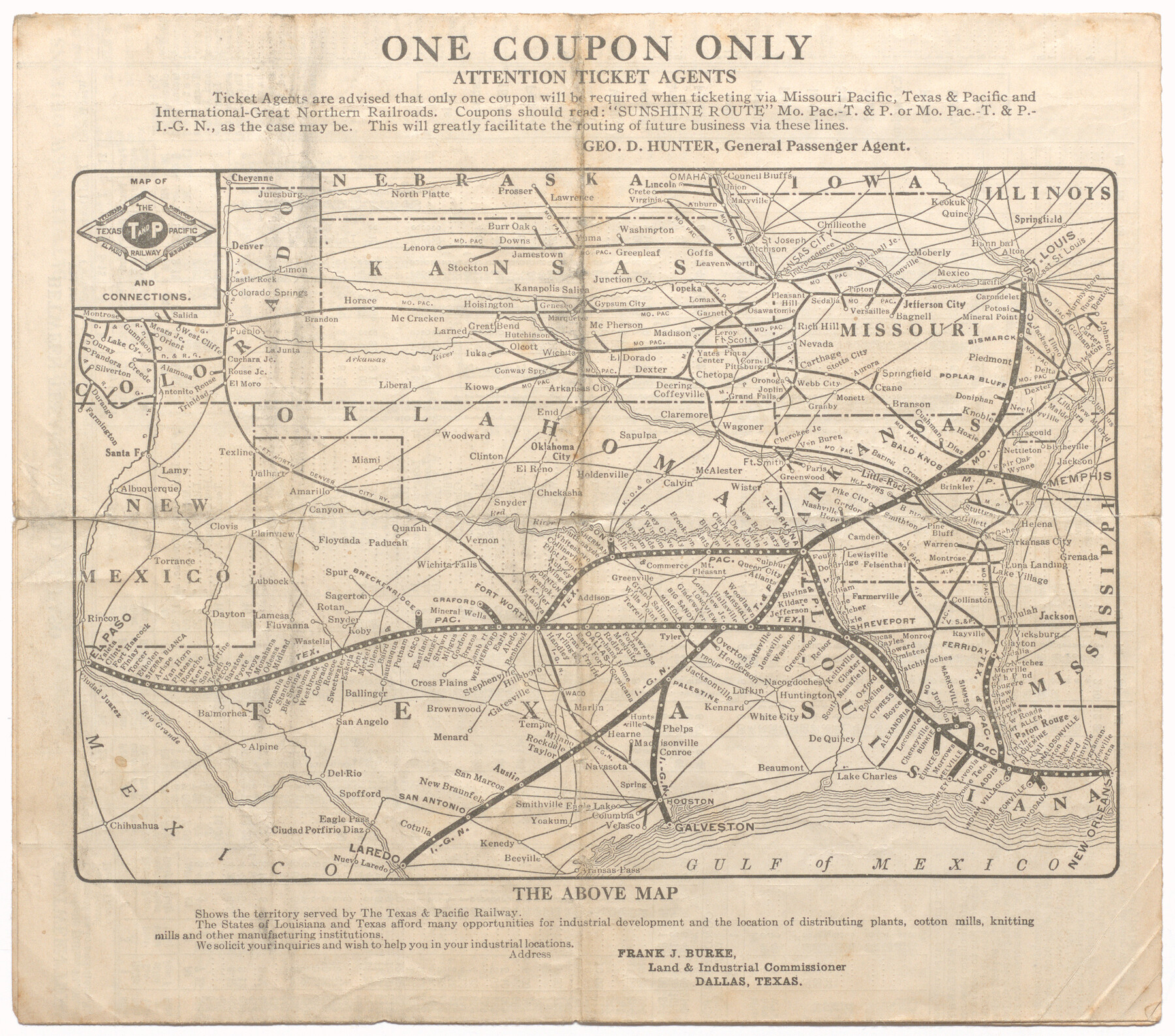
Map of the Texas and Pacific Railway and connections
The Texas and Pacific Railway Co. Time Tables
-
Map/Doc
95772
-
Collection
Cobb Digital Map Collection
-
Object Dates
1925 (Creation Date)
-
Subjects
Railroads Texas and Pacific Railroad
-
Height x Width
8.2 x 9.3 inches
20.8 x 23.6 cm
-
Medium
digital image
-
Comments
Courtesy of John & Diana Cobb.
To view booklet of time tables and other information in which this map appears, click "Download PDF" link above.
Part of: Cobb Digital Map Collection
Port Houston, the Commercial Center of the South and West

Port Houston, the Commercial Center of the South and West
1900
Size 4.9 x 6.5 inches
Map/Doc 97068


Correct Map of the Missouri, Kansas & Texas Railway and connections

Print $20.00
- Digital $50.00
Correct Map of the Missouri, Kansas & Texas Railway and connections
1895
Size 17.9 x 39.8 inches
Map/Doc 95808
Map of the Iron Mountain Route - St. Louis, Iron Mountain and Southern Railway and connections, the great fast mail line to St. Louis, Arkansas and Texas

Print $20.00
- Digital $50.00
Map of the Iron Mountain Route - St. Louis, Iron Mountain and Southern Railway and connections, the great fast mail line to St. Louis, Arkansas and Texas
1882
Size 14.9 x 24.1 inches
Map/Doc 95787
Map Exhibiting the Leading Transportation Lines of the Pacific Coast, prepared for the report of the Chief of the Bureau of Statistics on the internal commerce of the United States

Print $20.00
- Digital $50.00
Map Exhibiting the Leading Transportation Lines of the Pacific Coast, prepared for the report of the Chief of the Bureau of Statistics on the internal commerce of the United States
1887
Size 22.2 x 24.5 inches
Map/Doc 95905

Sectional map of Texas traversed by the Missouri, Kansas & Texas Railway, showing the crops adapted to each section, with the elevation and annual rainfall

Print $20.00
- Digital $50.00
Sectional map of Texas traversed by the Missouri, Kansas & Texas Railway, showing the crops adapted to each section, with the elevation and annual rainfall
1904
Size 21.9 x 22.6 inches
Map/Doc 95813

[Plat map of Provident City and surrounding] / Map showing the Gulf Coast Country and Railways and Water Shipping Facilities of the Provident Land Tract
![95819, [Plat map of Provident City and surrounding] / Map showing the Gulf Coast Country and Railways and Water Shipping Facilities of the Provident Land Tract, Cobb Digital Map Collection](https://historictexasmaps.com/wmedia_w700/maps/95819.tif.jpg)
Print $20.00
- Digital $50.00
[Plat map of Provident City and surrounding] / Map showing the Gulf Coast Country and Railways and Water Shipping Facilities of the Provident Land Tract
1908
Size 22.0 x 22.9 inches
Map/Doc 95819

You may also like
Hunt County Rolled Sketch 5

Print $20.00
- Digital $50.00
Hunt County Rolled Sketch 5
1966
Size 24.7 x 24.5 inches
Map/Doc 6275
Upton County Sketch File 33

Print $20.00
- Digital $50.00
Upton County Sketch File 33
1939
Size 19.4 x 20.8 inches
Map/Doc 12524
Schleicher County Sketch File 18

Print $20.00
- Digital $50.00
Schleicher County Sketch File 18
Size 15.1 x 25.0 inches
Map/Doc 12300
Map of Brazoria

Print $20.00
- Digital $50.00
Map of Brazoria
1931
Size 20.2 x 26.7 inches
Map/Doc 80134
Terrell County Rolled Sketch 9

Print $20.00
- Digital $50.00
Terrell County Rolled Sketch 9
Size 17.6 x 42.9 inches
Map/Doc 7925
Aransas County Working Sketch 22

Print $20.00
- Digital $50.00
Aransas County Working Sketch 22
Size 24.3 x 18.2 inches
Map/Doc 67189
Chambers County NRC Article 33.136 Sketch 1

Print $62.00
- Digital $50.00
Chambers County NRC Article 33.136 Sketch 1
2002
Size 24.6 x 36.2 inches
Map/Doc 77041
Phelps and Watson's Historical and Military Map of the Border and Southern States

Print $20.00
Phelps and Watson's Historical and Military Map of the Border and Southern States
1863
Size 25.5 x 36.3 inches
Map/Doc 76202
Flight Mission No. BRE-2P, Frame 17, Nueces County

Print $20.00
- Digital $50.00
Flight Mission No. BRE-2P, Frame 17, Nueces County
1956
Size 18.2 x 22.1 inches
Map/Doc 86726
Sutton County Rolled Sketch 38

Print $20.00
- Digital $50.00
Sutton County Rolled Sketch 38
1898
Size 19.6 x 35.1 inches
Map/Doc 7881
Terry County Rolled Sketch 10

Print $20.00
- Digital $50.00
Terry County Rolled Sketch 10
2001
Size 25.2 x 23.8 inches
Map/Doc 76414
Map Showing Location of Dallas & Greenville Railroad through Rockwall County, Texas

Print $3.00
- Digital $50.00
Map Showing Location of Dallas & Greenville Railroad through Rockwall County, Texas
Size 7.9 x 17.5 inches
Map/Doc 64485