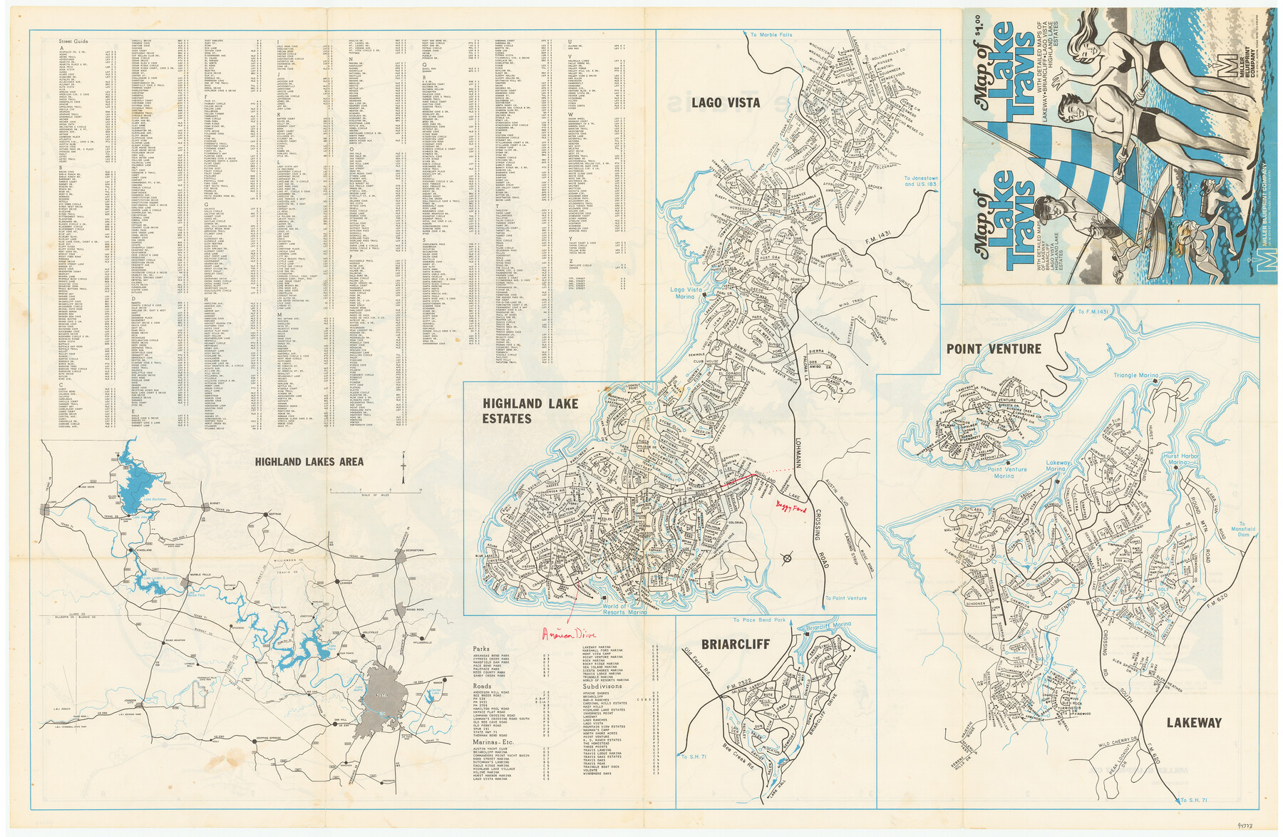
Map of Lake Travis with detailed maps of Lakeway, Briarcliff, Lago Vista, Highland Lake Estates
[Recto - Maps of Highland Lakes, Lago Vista, Briarcliff and Lakeway]
-
Map/Doc
94373
-
Collection
General Map Collection
-
Object Dates
1982 (Copyright Date)
-
People and Organizations
Miller Blueprint Company (Publisher)
-
Subjects
City
-
Height x Width
23.0 x 35.2 inches
58.4 x 89.4 cm
-
Medium
paper, etching/engraving/lithograph
-
Comments
For map of Lake Travis on verso, see 94374. For research only.
Related maps
Map of Lake Travis with detailed maps of Lakeway, Briarcliff, Lago Vista, Highland Lake Estates

Map of Lake Travis with detailed maps of Lakeway, Briarcliff, Lago Vista, Highland Lake Estates
Size 23.0 x 35.3 inches
Map/Doc 94374
Part of: General Map Collection
Flight Mission No. DQO-3K, Frame 19, Galveston County

Print $20.00
- Digital $50.00
Flight Mission No. DQO-3K, Frame 19, Galveston County
1952
Size 18.7 x 22.5 inches
Map/Doc 85060
Sutton County Sketch File 19

Print $8.00
- Digital $50.00
Sutton County Sketch File 19
1914
Size 11.4 x 8.8 inches
Map/Doc 37447
Brazoria County Working Sketch 33

Print $20.00
- Digital $50.00
Brazoria County Working Sketch 33
1980
Size 29.6 x 35.6 inches
Map/Doc 67518
Fort Bend County Working Sketch 24

Print $20.00
- Digital $50.00
Fort Bend County Working Sketch 24
1981
Size 27.1 x 30.5 inches
Map/Doc 69230
Maverick County Working Sketch 23

Print $20.00
- Digital $50.00
Maverick County Working Sketch 23
1985
Size 37.8 x 36.4 inches
Map/Doc 70915
Bell County Sketch File 6

Print $4.00
- Digital $50.00
Bell County Sketch File 6
Size 6.3 x 7.7 inches
Map/Doc 14373
Armstrong County Sketch File A-6

Print $40.00
- Digital $50.00
Armstrong County Sketch File A-6
1919
Size 18.3 x 15.8 inches
Map/Doc 10847
Comal County Rolled Sketch 2

Print $20.00
- Digital $50.00
Comal County Rolled Sketch 2
Size 21.6 x 13.0 inches
Map/Doc 5536
Port Series No. 6 - The Ports of Galveston, Houston, and Texas City, Texas

Port Series No. 6 - The Ports of Galveston, Houston, and Texas City, Texas
1924
Map/Doc 97159
Duval County Working Sketch 23

Print $20.00
- Digital $50.00
Duval County Working Sketch 23
1943
Size 41.8 x 37.8 inches
Map/Doc 68747
Trinity River, Irving Sheet

Print $4.00
- Digital $50.00
Trinity River, Irving Sheet
1925
Size 20.7 x 17.9 inches
Map/Doc 65212
Navigation Maps of Gulf Intracoastal Waterway, Port Arthur to Brownsville, Texas

Print $4.00
- Digital $50.00
Navigation Maps of Gulf Intracoastal Waterway, Port Arthur to Brownsville, Texas
1951
Size 16.6 x 21.5 inches
Map/Doc 65436
You may also like
Flight Mission No. CGI-3N, Frame 78, Cameron County

Print $20.00
- Digital $50.00
Flight Mission No. CGI-3N, Frame 78, Cameron County
1954
Size 18.6 x 22.3 inches
Map/Doc 84572
Flight Mission No. DCL-6C, Frame 50, Kenedy County

Print $20.00
- Digital $50.00
Flight Mission No. DCL-6C, Frame 50, Kenedy County
1943
Size 18.7 x 22.4 inches
Map/Doc 85892
Jeff Davis County Rolled Sketch 23A

Print $11.00
- Digital $50.00
Jeff Davis County Rolled Sketch 23A
1886
Size 9.9 x 15.3 inches
Map/Doc 46293
Moore County, Texas

Print $20.00
- Digital $50.00
Moore County, Texas
1888
Size 22.0 x 18.3 inches
Map/Doc 742
Flight Mission No. CUG-1P, Frame 28, Kleberg County

Print $20.00
- Digital $50.00
Flight Mission No. CUG-1P, Frame 28, Kleberg County
1956
Size 18.6 x 22.2 inches
Map/Doc 86118
New City Map of Laredo, Texas

Print $20.00
New City Map of Laredo, Texas
1930
Size 21.7 x 11.3 inches
Map/Doc 76277
[Sketch of surveys in the vicinity of sections 171 and 172 along Pedernales]
![91880, [Sketch of surveys in the vicinity of sections 171 and 172 along Pedernales], Twichell Survey Records](https://historictexasmaps.com/wmedia_w700/maps/91880-1.tif.jpg)
Print $20.00
- Digital $50.00
[Sketch of surveys in the vicinity of sections 171 and 172 along Pedernales]
Size 15.8 x 14.3 inches
Map/Doc 91880
University Land Field Notes for Block 19 in Loving and Ward Counties, Block 20 in Loving, Ward, and Winkler Counties, Blocks 16 and 18 in Ward County, Block 17 in Ward and Winkler Counties, and Block 21 in Winkler County

University Land Field Notes for Block 19 in Loving and Ward Counties, Block 20 in Loving, Ward, and Winkler Counties, Blocks 16 and 18 in Ward County, Block 17 in Ward and Winkler Counties, and Block 21 in Winkler County
Map/Doc 81709
Montague County Working Sketch 33

Print $20.00
- Digital $50.00
Montague County Working Sketch 33
1976
Size 30.6 x 43.3 inches
Map/Doc 71099
Flight Mission No. CRC-5R, Frame 30, Chambers County

Print $20.00
- Digital $50.00
Flight Mission No. CRC-5R, Frame 30, Chambers County
1956
Size 18.6 x 22.4 inches
Map/Doc 84949
Webb County Working Sketch 40

Print $20.00
- Digital $50.00
Webb County Working Sketch 40
1941
Size 19.6 x 20.6 inches
Map/Doc 72405
Flight Mission No. CGI-1N, Frame 134, Cameron County

Print $20.00
- Digital $50.00
Flight Mission No. CGI-1N, Frame 134, Cameron County
1955
Size 18.5 x 22.1 inches
Map/Doc 84490