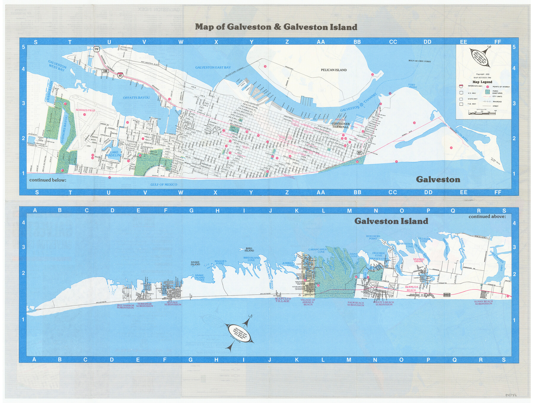
Galveston/Galveston Island, Texas
[Verso - Maps of Galveston and Galveston Island]
-
Map/Doc
94346
-
Collection
General Map Collection
-
Object Dates
1989 (Edition Date)
-
People and Organizations
H.M. Gousha (Publisher)
-
Counties
Galveston
-
Subjects
City
-
Height x Width
18.4 x 24.3 inches
46.7 x 61.7 cm
-
Medium
paper, etching/engraving/lithograph
-
Comments
For map of Galveston County on recto, see 94345. For research only.
Related maps
Galveston/Galveston Island, Texas

Galveston/Galveston Island, Texas
Size 18.4 x 24.2 inches
Map/Doc 94345
Part of: General Map Collection
Flight Mission No. DQO-8K, Frame 51, Galveston County

Print $20.00
- Digital $50.00
Flight Mission No. DQO-8K, Frame 51, Galveston County
1952
Size 18.7 x 22.3 inches
Map/Doc 85158
Louisiana and Texas Intracoastal Waterway - Gilchrist to Port Bolivar, Maintenance Dredging - Sheet 2

Print $20.00
- Digital $50.00
Louisiana and Texas Intracoastal Waterway - Gilchrist to Port Bolivar, Maintenance Dredging - Sheet 2
1937
Size 31.0 x 40.8 inches
Map/Doc 61821
Matagorda County NRC Article 33.136 Sketch 22

Print $24.00
Matagorda County NRC Article 33.136 Sketch 22
2025
Map/Doc 97486
[Sketch for Mineral Application 33721 - 33725 Incl. - Padre and Mustang Island]
![2869, [Sketch for Mineral Application 33721 - 33725 Incl. - Padre and Mustang Island], General Map Collection](https://historictexasmaps.com/wmedia_w700/maps/2869.tif.jpg)
Print $20.00
- Digital $50.00
[Sketch for Mineral Application 33721 - 33725 Incl. - Padre and Mustang Island]
1942
Size 22.2 x 22.3 inches
Map/Doc 2869
Right of Way and Track Map, the Missouri, Kansas & Texas Ry. Of Texas operated by the Missouri, Kansas & Texas Ry. Of Texas, Houston Division

Print $40.00
- Digital $50.00
Right of Way and Track Map, the Missouri, Kansas & Texas Ry. Of Texas operated by the Missouri, Kansas & Texas Ry. Of Texas, Houston Division
1918
Size 25.6 x 62.5 inches
Map/Doc 64786
Map of Texas and Pacific Ry. Company's Surveys in the 80 Mile Reserve

Print $20.00
- Digital $50.00
Map of Texas and Pacific Ry. Company's Surveys in the 80 Mile Reserve
1885
Size 44.0 x 46.6 inches
Map/Doc 83558
The Railroad System of Texas on September 1st, 1887

Print $20.00
- Digital $50.00
The Railroad System of Texas on September 1st, 1887
1887
Size 22.2 x 28.2 inches
Map/Doc 3036
Brazos County Working Sketch 3

Print $20.00
- Digital $50.00
Brazos County Working Sketch 3
1976
Size 22.0 x 18.4 inches
Map/Doc 67478
Pecos County Working Sketch 96

Print $20.00
- Digital $50.00
Pecos County Working Sketch 96
1970
Size 41.2 x 39.0 inches
Map/Doc 71569
Rusk County Sketch File 25

Print $20.00
Rusk County Sketch File 25
1932
Size 20.5 x 20.3 inches
Map/Doc 12272
Lavaca County Working Sketch 4

Print $20.00
- Digital $50.00
Lavaca County Working Sketch 4
1938
Size 27.7 x 42.4 inches
Map/Doc 70357
Brewster County Working Sketch 16

Print $20.00
- Digital $50.00
Brewster County Working Sketch 16
1930
Size 42.0 x 40.1 inches
Map/Doc 67550
You may also like
Montgomery County Rolled Sketch 37

Print $40.00
- Digital $50.00
Montgomery County Rolled Sketch 37
Size 44.3 x 52.7 inches
Map/Doc 9544
Nueces County Sketch File 12c

Print $11.00
- Digital $50.00
Nueces County Sketch File 12c
1889
Size 12.6 x 8.2 inches
Map/Doc 32534

Denton County Sketch File 2

Print $3.00
- Digital $50.00
Denton County Sketch File 2
1855
Size 15.4 x 9.8 inches
Map/Doc 20687
[Pencil sketch of surveys 820-831 along river]
![91983, [Pencil sketch of surveys 820-831 along river], Twichell Survey Records](https://historictexasmaps.com/wmedia_w700/maps/91983-1.tif.jpg)
Print $20.00
- Digital $50.00
[Pencil sketch of surveys 820-831 along river]
Size 23.0 x 10.3 inches
Map/Doc 91983
Texas Intracoastal Waterway - Stover Point to Port Brownsville including Brazos Santiago

Print $20.00
- Digital $50.00
Texas Intracoastal Waterway - Stover Point to Port Brownsville including Brazos Santiago
1965
Size 27.5 x 38.9 inches
Map/Doc 73521
Red River County Working Sketch 61

Print $20.00
- Digital $50.00
Red River County Working Sketch 61
1973
Size 37.8 x 38.5 inches
Map/Doc 72044
Preliminary Chart of Galveston Bay, Texas

Print $20.00
- Digital $50.00
Preliminary Chart of Galveston Bay, Texas
1855
Size 22.5 x 18.4 inches
Map/Doc 69867
City of Houston and Environs

Print $20.00
City of Houston and Environs
1895
Size 30.4 x 33.6 inches
Map/Doc 93486
Nueces County Rolled Sketch 84

Print $20.00
- Digital $50.00
Nueces County Rolled Sketch 84
1982
Size 18.1 x 24.7 inches
Map/Doc 6970
Franklin County Sketch File 2a

Print $6.00
- Digital $50.00
Franklin County Sketch File 2a
1857
Size 8.6 x 10.5 inches
Map/Doc 23012
Palo Pinto County Working Sketch 17

Print $40.00
- Digital $50.00
Palo Pinto County Working Sketch 17
1974
Size 30.0 x 53.8 inches
Map/Doc 71400