El Paso Street and Vicinity Map (Recto)
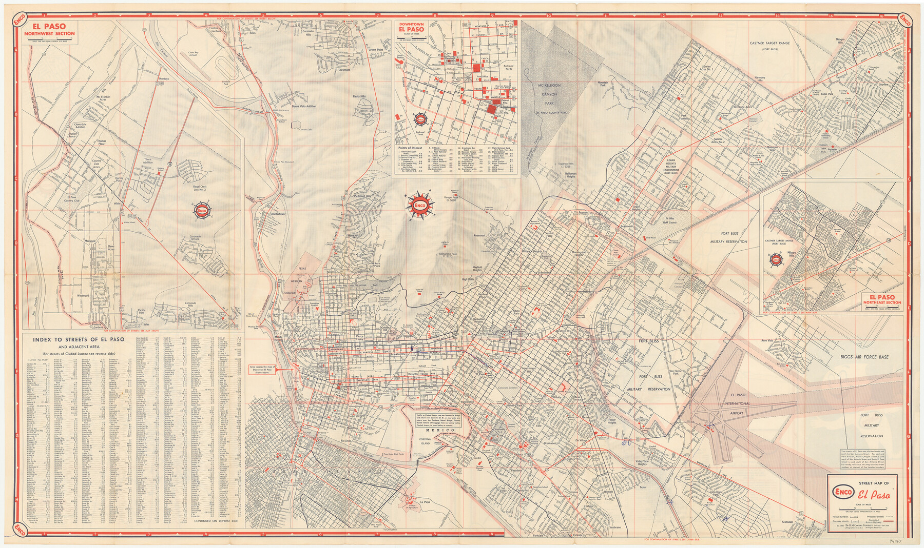
Street Map of El Paso [Insets: El Paso Northwest Section; Downtown El Paso; El Paso Northeast Section]
-
Map/Doc
94175
-
Collection
General Map Collection
-
Object Dates
1962 (Creation Date)
-
People and Organizations
The H.M. Gousha Company (Publisher)
James Harkins (Donor)
-
Counties
El Paso
-
Subjects
City
-
Height x Width
18.3 x 30.8 inches
46.5 x 78.2 cm
-
Medium
paper, etching/engraving/lithograph
-
Comments
For reference/research purposes only. Promotional map of El Paso sponsored by Enco/Humble Oil & Refining Company. Donated by James Harkins. See 94176 for verso.
Related maps
El Paso Street and Vicinity Map (Verso)

El Paso Street and Vicinity Map (Verso)
1962
Size 18.3 x 30.8 inches
Map/Doc 94176
Part of: General Map Collection
Sketch from old map (authority unknown) showing a portion of the Rio Grande River and harbor of Brazos Santiago, Texas

Print $20.00
- Digital $50.00
Sketch from old map (authority unknown) showing a portion of the Rio Grande River and harbor of Brazos Santiago, Texas
1887
Size 18.1 x 24.3 inches
Map/Doc 73003
Brazoria County

Print $40.00
- Digital $50.00
Brazoria County
1891
Size 47.1 x 54.2 inches
Map/Doc 4890
Waller County Working Sketch 4

Print $20.00
- Digital $50.00
Waller County Working Sketch 4
1965
Size 17.3 x 18.8 inches
Map/Doc 72303
Reagan County Sketch File 1

Print $20.00
- Digital $50.00
Reagan County Sketch File 1
1914
Size 24.3 x 30.3 inches
Map/Doc 12210
Flight Mission No. BRA-16M, Frame 181, Jefferson County

Print $20.00
- Digital $50.00
Flight Mission No. BRA-16M, Frame 181, Jefferson County
1953
Size 18.6 x 22.2 inches
Map/Doc 85779
Map of Johnson County & Hood County

Print $20.00
- Digital $50.00
Map of Johnson County & Hood County
1863
Size 19.3 x 28.3 inches
Map/Doc 3735
Zavala County Sketch File 50

Print $10.00
- Digital $50.00
Zavala County Sketch File 50
1956
Size 14.6 x 9.1 inches
Map/Doc 41446
Flight Mission No. CRC-3R, Frame 17, Chambers County

Print $20.00
- Digital $50.00
Flight Mission No. CRC-3R, Frame 17, Chambers County
1956
Size 18.6 x 22.2 inches
Map/Doc 84791
Hunt County Sketch File 49

Print $4.00
- Digital $50.00
Hunt County Sketch File 49
1852
Size 7.3 x 8.9 inches
Map/Doc 27168
Cherokee County Boundary File 6 and 15

Print $8.00
- Digital $50.00
Cherokee County Boundary File 6 and 15
Size 8.3 x 6.7 inches
Map/Doc 51301
Duval County Working Sketch 15

Print $20.00
- Digital $50.00
Duval County Working Sketch 15
1938
Size 23.3 x 22.7 inches
Map/Doc 68728
Orange County Sketch File 24

Print $6.00
- Digital $50.00
Orange County Sketch File 24
Size 8.9 x 15.7 inches
Map/Doc 33353
You may also like
Uvalde County

Print $20.00
- Digital $50.00
Uvalde County
1976
Size 42.7 x 46.4 inches
Map/Doc 73310
Aransas County Sketch File 5

Print $4.00
- Digital $50.00
Aransas County Sketch File 5
1850
Size 12.1 x 7.9 inches
Map/Doc 13108
Van Zandt County Sketch File 29a

Print $4.00
- Digital $50.00
Van Zandt County Sketch File 29a
1859
Size 14.2 x 6.6 inches
Map/Doc 39455
Webb County Sketch File B

Print $20.00
- Digital $50.00
Webb County Sketch File B
Size 15.9 x 13.7 inches
Map/Doc 12605
Flight Mission No. DAH-9M, Frame 160, Orange County

Print $20.00
- Digital $50.00
Flight Mission No. DAH-9M, Frame 160, Orange County
1953
Size 18.4 x 22.2 inches
Map/Doc 86859
Newton County Rolled Sketch 4

Print $20.00
- Digital $50.00
Newton County Rolled Sketch 4
1893
Size 21.1 x 19.7 inches
Map/Doc 6840
Lampasas County Working Sketch 24

Print $20.00
- Digital $50.00
Lampasas County Working Sketch 24
Size 14.3 x 13.3 inches
Map/Doc 61796
Duval County Working Sketch 29

Print $20.00
- Digital $50.00
Duval County Working Sketch 29
1948
Size 28.9 x 31.5 inches
Map/Doc 68753
Dallas County Sketch File 12

Print $20.00
- Digital $50.00
Dallas County Sketch File 12
1853
Size 25.4 x 25.2 inches
Map/Doc 11284
Part of Garza, Crosby, Lynn, and Lubbock Counties

Print $20.00
- Digital $50.00
Part of Garza, Crosby, Lynn, and Lubbock Counties
Size 25.3 x 20.2 inches
Map/Doc 91300
Zapata County Sketch File 16

Print $6.00
- Digital $50.00
Zapata County Sketch File 16
Size 14.5 x 8.8 inches
Map/Doc 40957
Eastland County Working Sketch 27

Print $20.00
- Digital $50.00
Eastland County Working Sketch 27
1952
Size 25.2 x 21.4 inches
Map/Doc 68808