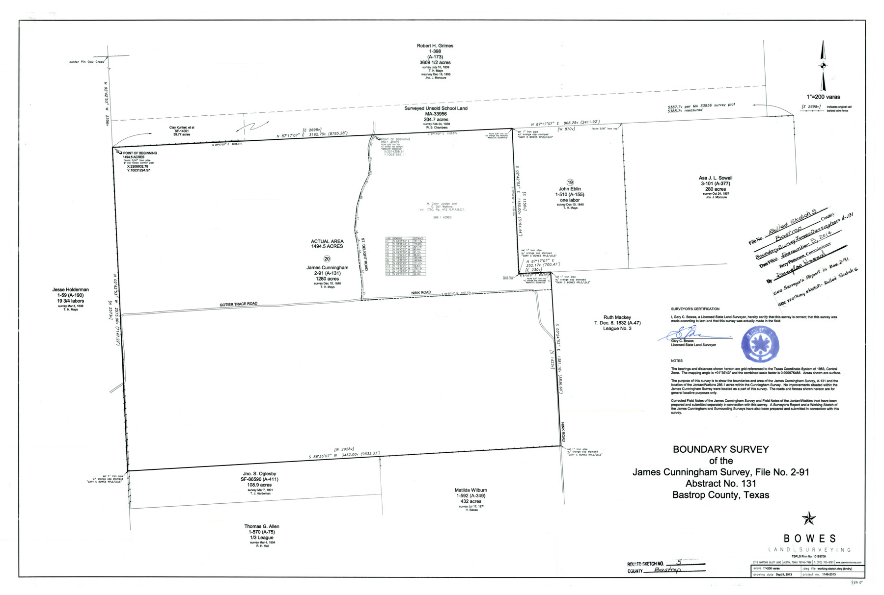
Bastrop County Rolled Sketch 5
Boundary survey of the James Cunningham survey, File No. 2-91 Abstract No. 131
-
Map/Doc
93715
-
Collection
General Map Collection
-
Object Dates
2013/9/5 (Creation Date)
2014/12/5 (File Date)
-
People and Organizations
Gary C. Bowes (Surveyor/Engineer)
-
Counties
Bastrop
-
Subjects
Surveying Rolled Sketch
-
Height x Width
24.9 x 36.9 inches
63.2 x 93.7 cm
-
Medium
mylar, print
-
Scale
1" = 200 varas
-
Comments
See Bastrop County Rolled Sketch 6 (93716) for related sketch and file BAS 2-91 for surveyor's report.
Related maps
Bastrop County Rolled Sketch 6

Print $20.00
- Digital $50.00
Bastrop County Rolled Sketch 6
2013
Size 42.3 x 32.1 inches
Map/Doc 93716
Part of: General Map Collection

Flight Mission No. BRE-2P, Frame 94, Nueces County

Print $20.00
- Digital $50.00
Flight Mission No. BRE-2P, Frame 94, Nueces County
1956
Size 18.6 x 22.3 inches
Map/Doc 86779
Fort Bend Co.

Print $20.00
- Digital $50.00
Fort Bend Co.
1931
Size 39.1 x 40.8 inches
Map/Doc 73150
Morris County Sketch File 4

Print $4.00
- Digital $50.00
Morris County Sketch File 4
1910
Size 8.3 x 8.6 inches
Map/Doc 31968
Gulf, Texas & Western Railway

Print $40.00
- Digital $50.00
Gulf, Texas & Western Railway
1909
Size 18.5 x 121.0 inches
Map/Doc 64430
Jones County Boundary File 1b

Print $40.00
- Digital $50.00
Jones County Boundary File 1b
1882
Size 37.5 x 12.6 inches
Map/Doc 44359
El Paso County Working Sketch 41

Print $20.00
- Digital $50.00
El Paso County Working Sketch 41
1985
Size 30.3 x 31.6 inches
Map/Doc 69063
Real County Working Sketch 10

Print $20.00
- Digital $50.00
Real County Working Sketch 10
1929
Size 23.0 x 15.4 inches
Map/Doc 71902
Val Verde County Sketch File 8

Print $38.00
- Digital $50.00
Val Verde County Sketch File 8
1885
Size 22.6 x 23.2 inches
Map/Doc 12564
Potter County Sketch File 22

Print $30.00
- Digital $50.00
Potter County Sketch File 22
1962
Size 14.2 x 8.6 inches
Map/Doc 34415
Maverick County Sketch File 25

Print $20.00
- Digital $50.00
Maverick County Sketch File 25
1914
Size 18.4 x 25.6 inches
Map/Doc 12055
Navarro County Sketch File 2

Print $4.00
- Digital $50.00
Navarro County Sketch File 2
1857
Size 9.4 x 8.2 inches
Map/Doc 32298
You may also like
[Map Showing Estivan Martinez "Los Nerios de Tio Ayola" Survey and Surveys North Thereof, Brooks County, Texas]
![10755, [Map Showing Estivan Martinez "Los Nerios de Tio Ayola" Survey and Surveys North Thereof, Brooks County, Texas], Maddox Collection](https://historictexasmaps.com/wmedia_w700/maps/10755.tif.jpg)
Print $20.00
- Digital $50.00
[Map Showing Estivan Martinez "Los Nerios de Tio Ayola" Survey and Surveys North Thereof, Brooks County, Texas]
1906
Size 16.7 x 25.1 inches
Map/Doc 10755
Culberson County Working Sketch 51

Print $40.00
- Digital $50.00
Culberson County Working Sketch 51
1972
Size 65.0 x 34.0 inches
Map/Doc 68505
Nueces County Rolled Sketch 78

Print $53.00
Nueces County Rolled Sketch 78
1982
Size 18.2 x 24.9 inches
Map/Doc 6945
Brooks County Working Sketch 15

Print $20.00
- Digital $50.00
Brooks County Working Sketch 15
1944
Size 30.5 x 20.5 inches
Map/Doc 67799
Schleicher County Working Sketch 25

Print $20.00
- Digital $50.00
Schleicher County Working Sketch 25
1958
Size 29.2 x 13.2 inches
Map/Doc 63827
Duval County Rolled Sketch 44

Print $40.00
- Digital $50.00
Duval County Rolled Sketch 44
1981
Size 36.5 x 90.5 inches
Map/Doc 8821
Fannin County Sketch File 9a

Print $4.00
- Digital $50.00
Fannin County Sketch File 9a
Size 8.2 x 6.4 inches
Map/Doc 22455
[Surveys in Milam District between the Bosque and Brazos Rivers]
![3, [Surveys in Milam District between the Bosque and Brazos Rivers], General Map Collection](https://historictexasmaps.com/wmedia_w700/maps/3.tif.jpg)
Print $20.00
- Digital $50.00
[Surveys in Milam District between the Bosque and Brazos Rivers]
1847
Size 15.8 x 12.2 inches
Map/Doc 3
Kinney County Working Sketch 38

Print $20.00
- Digital $50.00
Kinney County Working Sketch 38
1971
Size 28.9 x 30.6 inches
Map/Doc 70220
Goliad County Sketch File 25

Print $6.00
- Digital $50.00
Goliad County Sketch File 25
1856
Size 12.3 x 7.8 inches
Map/Doc 24305
Right of Way and Track Map, the Missouri, Kansas and Texas Ry. of Texas - Henrietta Division

Print $20.00
- Digital $50.00
Right of Way and Track Map, the Missouri, Kansas and Texas Ry. of Texas - Henrietta Division
1918
Size 11.8 x 27.0 inches
Map/Doc 64761
Montgomery County

Print $20.00
- Digital $50.00
Montgomery County
1895
Size 21.6 x 24.8 inches
Map/Doc 3897